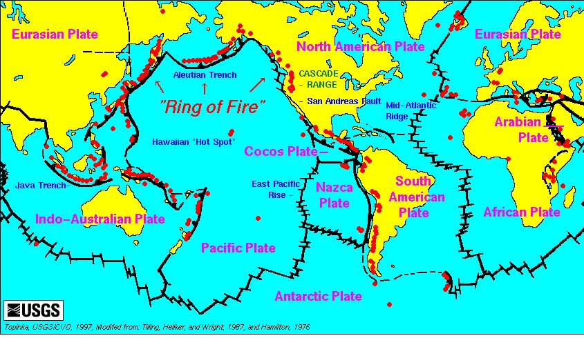
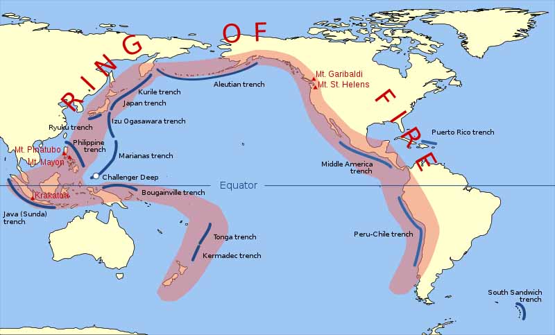
The Ring of Fire is a major area in the basin of the Pacific Ocean where a large number of earthquakes and volcanic eruptions occur. In a 40,000 km (25,000 mi) horseshoe shape, it is associated with a nearly continuous series of oceanic trenches, volcanic arcs, and volcanic belts and/or plate movements. It has 452 volcanoes (more than 75% of the world's active and dormant volcanoes). The Ring of Fire is sometimes called the circum-Pacific belt.
About 90% of the world's earthquakes and 81% of the world's largest earthquakes occur along the Ring of Fire. The next most seismically active region (5Đ6% of earthquakes and 17% of the world's largest earthquakes) is the Alpide belt, which extends from Java to the northern Atlantic Ocean via the Himalayas and southern Europe.
All but three of the world's 25 largest volcanic eruptions of the last 11,700 years occurred at volcanoes in the Ring of Fire.
The Ring of Fire is a direct result of plate tectonics: the movement and collisions of lithospheric plates. The eastern section of the ring is the result of the Nazca Plate and the Cocos Plate being subducted beneath the westward-moving South American Plate.
The Cocos Plate is being subducted beneath the Caribbean Plate, in Central America. A portion of the Pacific Plate and the small Juan de Fuca Plate are being subducted beneath the North American Plate.
Along the northern portion, the northwestward-moving Pacific plate is being subducted beneath the Aleutian Islands arc. Farther west, the Pacific plate is being subducted along the Kamchatka Peninsula arcs on south past Japan.
The southern portion is more complex, with a number of smaller tectonic plates in collision with the Pacific plate from the Mariana Islands, the Philippines, Bougainville, Tonga, and New Zealand; this portion excludes Australia, since it lies in the center of its tectonic plate. Indonesia lies between the Ring of Fire along the northeastern islands adjacent to and including New Guinea and the Alpide belt along the south and west from Sumatra, Java, Bali, Flores, and Timor. The famous and very active San Andreas Fault zone of California is a transform fault which offsets a portion of the East Pacific Rise under southwestern United States and Mexico.
The motion of the fault generates numerous small earthquakes, at multiple times a day, most of which are too small to be felt. The active Queen Charlotte Fault on the west coast of the Haida Gwaii, British Columbia, has generated three large earthquakes during the 20th century: a magnitude 7 event in 1929; a magnitude 8.1 in 1949 (Canada's largest recorded earthquake); and a magnitude 7.4 in 1970. Read more

2025 Kamchatka Peninsula Earthquake Wikipedia
Tsunami waves hit US shores after 8.8 magnitude quake strikes Russia's far east - 6th most powerful ever recorded CNN - July 30, 2025
The region is known for seismic activity due to its location in the Pacific Ring of Fire - a belt in the Pacific where the world's most active volcanoes are located. Russian volcano explodes in 'powerful' eruption, likely intensified by 8.8 magnitude earthquake Live Science - July 30, 2025
Aftershocks are expected to continue for some time, though decreasing in frequency and magnitude.
Climate change and natural disasters continue to accelerate exponentially as we move to closure. This summer has seen unprecedented global flooding and extreme heat. All of the tectonic plates are broken or fractured highlighted with the Pacific Plate.
The 8.8 pacific earthquake could have affected this predicted event ... Undersea Volcano Off The US West Coast Predicted To Erupt In 2025
Maps reveal new details about New Zealand's lost underwater continent CNN - June 23, 2020
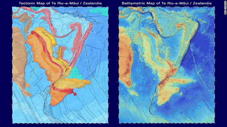
Millions of years later, the world's tectonic plates - pieces of the Earth's crust - began reorganizing themselves, in a period of dramatic geological change that also created the Pacific 'Ring of Fire,' a belt in the Pacific where the world's most active volcanoes are located.
EARTHQUAKES
PLATE TECTONICS
CONTINENTAL DRIFT
LAND BRIDGE