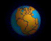
Continental drift is the movement of the Earth's continents relative to each other. The hypothesis that continents 'drift' was first put forward by Abraham Ortelius in 1596 and was fully developed by Alfred Wegener in 1912 when he noticed that the shapes of continents on either side of the Atlantic Ocean seem to fit together (for example, Africa and South America). Francis Bacon, Antonio Snider-Pellegrini, Benjamin Franklin, and others had noted much the same thing earlier. However, it was not until the development of the theory of plate tectonics in the 1960s, that a sufficient geological explanation of that movement was found.
The similarity of southern continent fossil faunas and some geological formations had led a relatively small number of Southern hemisphere geologists to conjecture as early as 1900 that all the continents had once been joined into a supercontinent known as Pangaea.
The concept was initially ridiculed by most geologists, who felt that an explanation of how a continent drifted was a prerequisite and that the lack of one made the idea of drifting continents wholly unreasonable.
The theory received support through the controversial years from South African geologist Alexander Du Toit as well as from Arthur Holmes. The idea of continental drift did not become widely accepted as theory until the 1950s in Europe.
By the 1960s, geological research conducted by Robert Dietz, Bruce Heezen, and Harry Hess along with a rekindling of the theory including a mechanism by J. Tuzo Wilson led to acceptance among North American geologists.
The hypothesis of continental drift became part of the larger theory of plate tectonics. This article deals mainly with the historical development of the continental drift hypothesis before 1950.
Evidence for the movement of continents on tectonic plates is now extensive. Similar plant and animal fossils are found around the shores of different continents, suggesting that they were once joined. The fossils of Mesosaurus, a freshwater reptile rather like a small crocodile, found both in Brazil and South Africa, are one example; another is the discovery of fossils of the land reptile Lystrosaurus in rocks of the same age at locations in Africa, India, and Antarctica. There is also living evidence the same animals being found on two continents. Some earthworm families (e.g. Ocnerodrilidae, Acanthodrilidae, Octochaetidae) are found in South America and Africa, for instance.
The complementary arrangement of the facing sides of South America and Africa is obvious, but is a temporary coincidence. In millions of years, slab pull and ridge-push, and other forces of tectonophysics, will further separate and rotate those two continents. It was this temporary feature which inspired Wegener to study what he defined as continental drift, although he did not live to see his hypothesis generally accepted.
Widespread distribution of Permo-Carboniferous glacial sediments in South America, Africa, Madagascar, Arabia, India, Antarctica and Australia was one of the major pieces of evidence for the theory of continental drift. The continuity of glaciers, inferred from oriented glacial striations and deposits called tillites, suggested the existence of the supercontinent of Gondwana, which became a central element of the concept of continental drift. Striations indicated glacial flow away from the equator and toward the poles, based on continents' current positions and orientations, and supported the idea that the southern continents had previously been in dramatically different locations, as well as being contiguous with each other. Continental Drift Hypothesis
The evolution of tectonophysics is closely linked to the history of the continental drift and plate tectonics hypotheses. The continental drift hypothesis had many flaws and scarce data. The fixist, the contracting Earth and the expanding Earth concepts had many flaws as well. Wegener had data for assuming that the relative positions of the continents change over time. It was a mistake to state the continents "plowed" through the sea.
He was an outsider with a doctorate in astronomy attacking a established theory between geophysicists. The geophysicists were right to state that the Earth is solid, and the mantle is elastic (for seismic waves) and inhomogeneous, and the ocean floor would not allow the movement of the continents.
But excluding one alternative, substantiates the opposite alternative: passive continents and an active seafloor spreading and subduction, with accretion belts on the edges of the continents. The velocity of the sliding continents, was allowed in the uncertainty of the fixed continent model and seafloor subduction and upwelling with phase change allows for inhomogeneity.
The problem too, was the specialization. A. Holmes and A. Rittmann saw it right (Rittmann 1939). Only an outsider can have the overview, only an outsider sees the forest, not only the trees (Hellman 1998b, p. 145). But A. Wegener did not have the specialization to correctly weight the quality of the geophysical data and the paleontologic data, and its conclusions. Wegener's main interest was meteorology, and he wanted to join the Denmark-Greenland expedition scheduled for mid 1912. So he hurried up to present his Continental Drift hypothesis.
Timeline of the Development of Tectonophysics
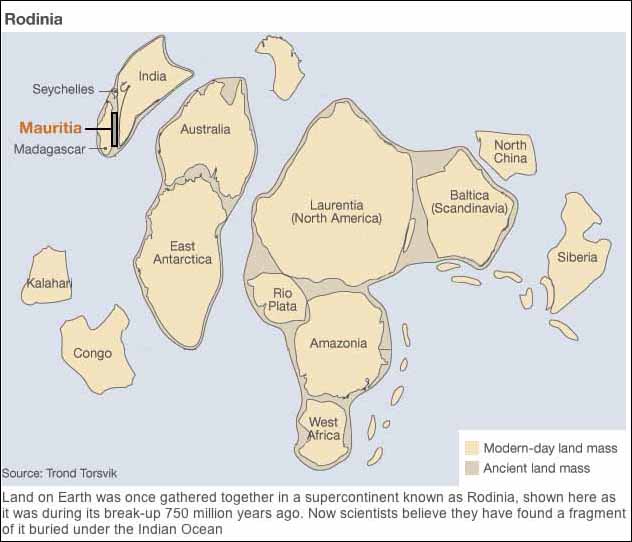
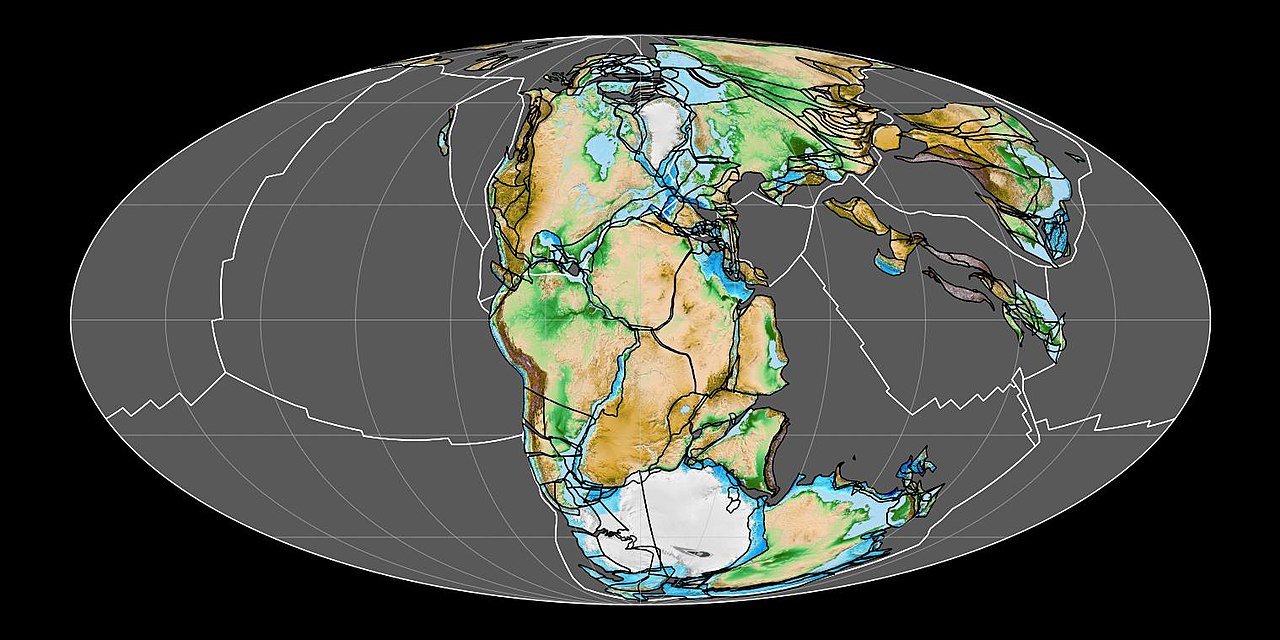
In geology, Rodinia - Russian for "to give birth" - is the name of a supercontinent, a continent which contained most or all of Earth's landmass. According to plate tectonic reconstructions, Rodinia existed between 1.1 billion and 750 million years ago, in the Neoproterozoic era. It formed at ~1.0 Ga by accretion and collision of fragments produced by breakup of the older supercontinent, Columbia, which was assembled by global-scale 2.0-1.8 Ga collisional events.
Rodinia has entered popular consciousness as one of the two great supercontinents of earth history, the other being Pangaea a supercontinent that existed during the late Paleozoic and early Mesozoic eras, forming about 300 million years ago that began to rift around 200 million years ago, before the component continents were separated into their current configurations.
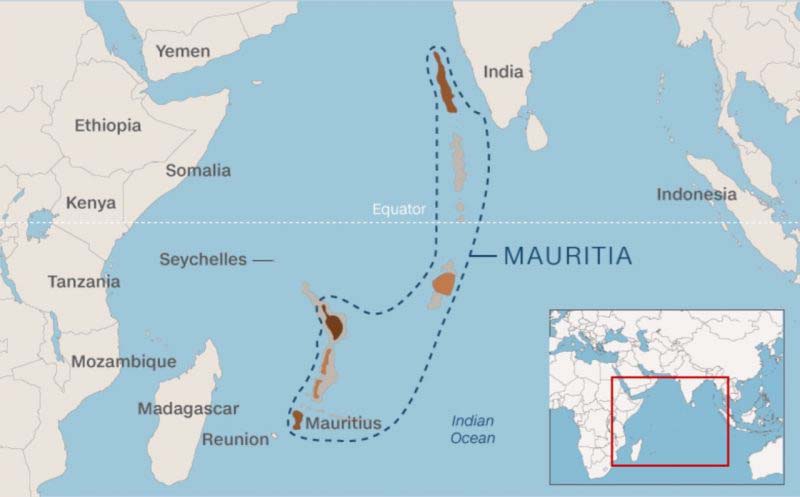
Mauritia was a Precambrian microcontinent that was situated between India and Madagascar until their separation about 70 million years ago. Being initially attached to the Indian continent, Mauritia separated from it about 60 million years ago and further fragmented into a ribbon-like structure as the mid-ocean ridge jumped several times. The jumps of the mid-ocean ridge are thought to have been caused of its interaction with the Reunion hotspot as it passed under the West margin of the Indian continent and then under Mauritia. As of today, the fragments of Mauritia include the Laccadives-Maldives-Chagos Ridge, Nazareth Bank, the Saya de Malha Bank, and Hawkins Bank, as well as the islands of Reunion and Mauritius, where the continual crust is buried under basaltic lavas of the Reunion hotspot.
Evidence for Mauritia's existence consists of detrital zircon found in rock (6-million-year-old trachyte) on Mauritius. Analyses of the zircon crystals produced dates between 660 and 1,970 million years and are considerably older than the 8.9-million-year-old basalt that constitutes the oldest formations on the island. The zircons are interpreted to have been brought up from buried continental crust as fragments entrained as xenocrysts within the basalt. Interpretation of a linear northwest-southeast gravity anomaly indicates the microcontinent may extend 1,500 kilometres (930 mi) from Seychelles to Mauritius roughly parallel to the Indian Ocean oceanic ridge
Fragments of ancient continent buried under Indian Ocean BBC - February 25, 2013
Fragments of an ancient continent are buried beneath the floor of the Indian Ocean, a study suggests. Researchers have found evidence for a landmass that would have existed between 2,000 and 85 million years ago. The strip of land, which scientists have called Mauritia, eventually fragmented and vanished beneath the waves as the modern world started to take shape. Evidence constituted of zircon found on Mauritius beaches; the zircon pieces are considerably older than the basalt that constitutes the oldest formations on the island at 8.9 million years.
Until about 750 million years ago, the Earth's landmass was gathered into a vast single continent called Rodinia. And although they are now separated by thousands of kilometres of ocean, India was once located next to Madagascar. Now researchers believe they have found evidence of a sliver of continent - known as a microcontinent - that was once tucked between the two.
The team came to this conclusion after studying grains of sand from the beaches of Mauritius. While the grains dated back to a volcanic eruption that happened about nine million years ago, they contained minerals that were much older. Professor Trond Torsvik, from the University of Oslo, Norway, said: "We found zircons that we extracted from the beach sands, and these are something you typically find in a continental crust. They are very old in age." The zircon dated to between 1,970 and 600 million years ago, and the team concluded that they were remnants of ancient land that had been dragged up to the surface of the island during a volcanic eruption. It would have spanned millions years of history, from the Precambrian Era when land was barren and devoid of life to the age when dinosaurs roamed the Earth.
But about 85m years ago, as India started to drift away from Madagascar towards its current location, the microcontinent would have broken up, eventually disappearing beneath the waves. However, a small part could have survived. "At the moment the Seychelles is a piece of granite, or continental crust, which is sitting practically in the middle of the Indian Ocean," explained Prof Torsvik. "But once upon a time, it was sitting north of Madagascar. And what we are saying is that maybe this was much bigger, and there are many of these continental fragments that are spread around in the ocean." Further research is needed to fully investigate what remains of this lost region.

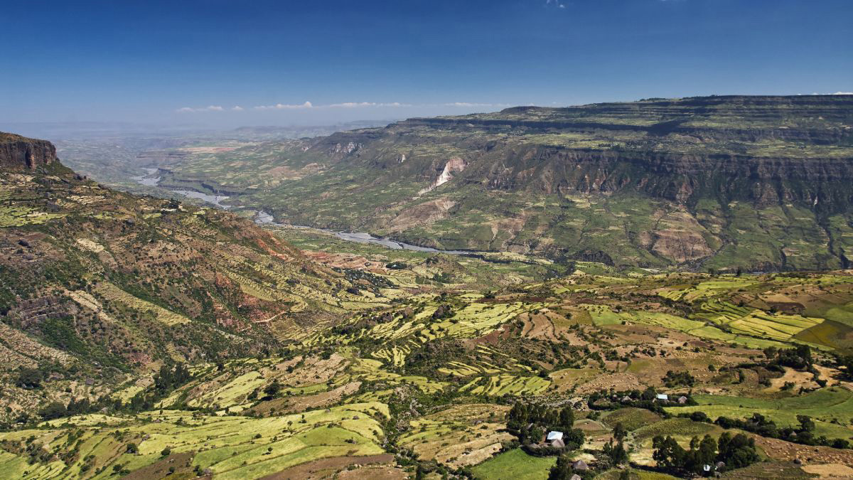
The Great Rift Valley is a series of contiguous geographic trenches, approximately 7,000 kilometres (4,300 mi) in total length, that runs from Lebanon in Asia to Mozambique in Southeast Africa. While the name continues in some usages, it is rarely used in geology as it is considered an imprecise merging of separate though related rift and fault systems.
This valley extends northward for 5,950 km through the eastern part of Africa, through the Red Sea, and into Western Asia. Several deep, elongated lakes, called ribbon lakes, exist on the floor of this rift valley: Lakes Malawi, Rudolf and Tanganyika are examples of such lakes. The region has a unique ecosystem and contains a number of Africa's wildlife parks.
The term Great Rift Valley is most often used to refer to the valley of the East African Rift, the divergent plate boundary which extends from the Afar Triple Junction southward through eastern Africa, and is in the process of splitting the African Plate into two new and separate plates. Geologists generally refer to these evolving plates as the Nubian Plate and the Somali Plate. Continue reading
Fountains of diamonds that erupt from Earth's center are revealing the lost history of supercontinents Live Science - January 15, 2024
Diamonds seem to reach Earth's surface in massive volcanic eruptions when supercontinents break up, and they form when continents come together.
Is Africa splitting into two continents? Live Science - June 17, 2023
A giant rift is slowly tearing Africa, the second-largest continent, apart. This depression - known as the East African Rift - is a network of valleys that stretches about 2,175 miles (3,500 kilometers) long, from the Red Sea to Mozambique.ill Africa rip apart completely, and if so, when will it split? To answer this question, let's look at the region's tectonic plates, the outer parts of the planet's surface that can collide with each other, making mountains, or pull apart, creating vast basins. Along this colossal tear in eastern Africa, the Somalian tectonic plate is pulling eastward from the larger, older part of the continent, the Nubian tectonic plate, according to NASA's Earth Observatory. (The Somalian plate is also known as the Somali plate, and the Nubian plate is also sometimes called the African plate.)
Continental Drift: The groundbreaking theory of moving continents Live Science - December 14, 2021
Continental drift was a revolutionary theory explaining that continents shift position on Earth's surface. The theory was proposed by geophysicist and meteorologist Alfred Wegener in 1912, but was rejected by mainstream science at the time. Scientists confirmed some of Wegener's ideas decades later, which are now part of the widely accepted theory of plate tectonics. Wegener's continental drift theory introduced the idea of moving continents to geoscience. He proposed that Earth must have once been a single supercontinent before breaking up to form several different continents. This explained how similar rock formations and plant and animal fossils could exist on separated continents. Modern science recognizes this ancient supercontinent called Pangaea did exist before breaking up about 200 million years ago, as Wegener theorized.
The African continent is very slowly peeling apart. Scientists say a new ocean is being born NBC - July 19, 2020
In one of the hottest places on Earth, along an arid stretch of East Africa's Afar region, it's possible to stand on the exact spot where, deep underground, the continent is splitting apart. This desolate expanse sits atop the juncture of three tectonic plates that are very slowly peeling away from each other, a complex geological process that scientists say will eventually cleave Africa in two and create a new ocean basin millions of years from now. For now, the most obvious evidence is a 35-mile-long crack in the Ethiopian desert.
Maps reveal new details about New Zealand's lost underwater continent CNN - June 23, 2020
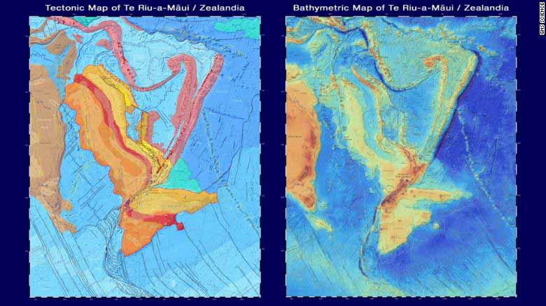
Under New Zealand, there lies a vast continent on the sea floor. Once part of the same land mass as Antarctica and Australia, the lost continent of Zealandia broke off 85 million years ago and eventually sank below the ocean, where it stayed largely hidden for centuries.
Now, maps reveal new research about the underwater continent where dinosaurs once roamed - and allow the public to virtually explore it.
GNS Science, a New Zealand research institute, published two new maps and an interactive website on Monday. The maps cover the shape of the ocean floor and Zealandia's tectonic profile, which collectively help tell the story of the continent's origins.
The lost continent of Zealandia hides clues to the Ring of Fire's birth Live Science - February 11, 2020
The hidden undersea continent of Zealandia underwent an upheaval at the time of the birth of the Pacific Ring of Fire. Zealandia is a chunk of continental crust next door to Australia. It's almost entirely beneath the ocean, with the exception of a few protrusions, like New Zealand and New Caledonia. But despite its undersea status, Zealandia is not made of magnesium- and iron-rich oceanic crust. Instead, it is composed of less-dense continental crust. The existence of this odd geology has been known since the 1970s, but only more recently has Zealandia been more closely explored. In 2017, geoscientists reported in the journal GSA Today that Zealandia qualifies as a continent in its own right, thanks to its structure and its clear separation from the Australian continent.
Diamond samples in Canada reveal size of lost continent BBC - March 21, 2020
Canadian scientists have discovered a fragment of an ancient continent, suggesting that it was 10% larger than previously thought.
They were studying diamond samples from Baffin Island, a glacier-covered land mass near Greenland, when they noticed a remnant of North Atlantic Craton. Cratons are ancient, stable parts of the Earth's continental crust. The North American Craton stretched from present-day Scotland to North America and broke apart 150m years ago. Scientists chanced on the latest evidence as they examined exploration samples of kimberlite, a rock that often contains diamonds, from Baffin Island.
Geologists find lost fragment of ancient continent in Canada's North PhysOrg - March 20, 2020
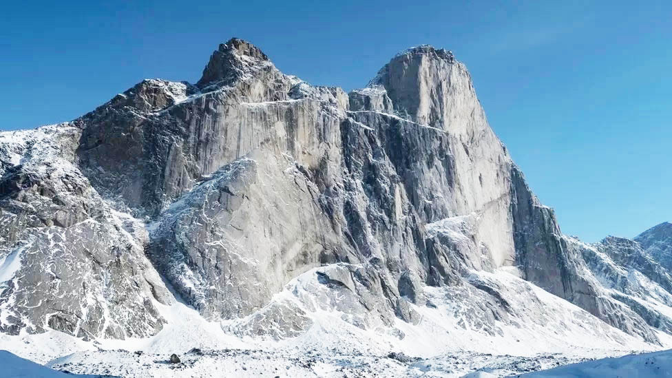
Sifting through diamond exploration samples from Baffin Island, Canadian scientists have identified a new remnant of the North Atlantic craton - an ancient part of Earth's continental crust. A chance discovery by geologists poring over diamond exploration samples has led to a major scientific payoff. Kimberlite rock samples are a mainstay of diamond exploration. Formed millions of years ago at depths of 150 to 400 kilometers, kimberlites are brought to the surface by geological and chemical forces. Sometimes, the igneous rocks carry diamonds embedded within them. The newly identified fragment covers the diamond bearing Chidliak kimberlite province in southern Baffin Island. It adds roughly 10 percent to the known expanse of the North Atlantic craton.
What are lost continents, and why are we discovering so many? In the past few years, we've seen an increase in the discovery of lost continents PhysOrg - November 25, 2019
For most people, continents are Earth's seven main large landmasses. But geoscientists have a different take on this. They look at the type of rock a feature is made of, rather than how much of its surface is above sea level. In the past few years, we've seen an increase in the discovery of lost continents. Most of these have been plateaus or mountains made of continental crust hidden from our view, below sea level. One example is Zealandia, the world's eighth continent that extends underwater from New Zealand. Several smaller lost continents, called microcontinents, have also recently been discovered submerged in the eastern and western Indian Ocean
Andes - Birthplace of Earth's Continents Discovered Under These Mountains Live Science - January 31, 2019
Earth's continents may have been born under large mountain ranges like the Andes. New research combining a mysterious missing trace element, a 66-million-year-old rock burped up by an ancient volcano, and a database of all the rock chemistry analyzed by scientists in the past century explains why Earth has continents. A study suggests that where mountains are born, so are continents.
How Earth's continents have shifted: Interactive map lets you travel back in time to see our planet over 600 million years of its history Daily Mail - May 4, 2018
A new interactive map lets you travel back in time to view our planet as it appeared millions of years ago. 'Ancient Earth Globe' reveals how the continents have split and reformed while oceans advanced and receded across 600 million years of the planet's history.
Big crack is evidence that East Africa could be splitting in two CNN - April 5, 2018
A large crack, stretching several kilometres, made a sudden appearance recently in south-western Kenya. The tear, which continues to grow, caused part of the Nairobi-Narok highway to collapse and was accompanied by seismic activity in the area. The Earth is an ever-changing planet, even though in some respects change might be almost unnoticeable to us. Plate tectonics is a good example of this. But every now and again something dramatic happens and leads to renewed questions about the African continent splitting in two. The Earth's lithosphere (formed by the crust and the upper part of the mantle) is broken up into a number of tectonic plates. These plates are not static, but move relative to each other at varying speeds, "gliding" over a viscous asthenosphere.
Breakup of supercontinent Pangea cooled mantle and thinned crust PhysOrg - December 13, 2016
The oceanic crust produced by the Earth today is significantly thinner than crust made 170 million years ago during the time of the supercontinent Pangea. The thinning is related to the cooling of Earth's interior prompted by the splitting of the supercontinent Pangaea, which broke up into the continents that we have today. The mantle is the very hot, but mostly solid, layer of rock between the Earth's crust and core. Magma from the mantle forms oceanic crust when it rises from the mantle to the surface at spreading centers and cools into the rock that forms the very bottom of the seafloor. Since about 2.5 billion years ago, the mantle has been cooling - a phenomenon that doesn't influence the climate on the surface of the Earth and has nothing to do with the issue of short-term man-made climate change.
GEOLOGY
CRUSTAL DISPLACEMENT