In the quest to find a unified sacred cosmology linking above with below, we come to the study of archeoastronomy. Here researchers finds many astronomical observatories and megalithic monuments whose origins defy explanation, leading one to conclude they were constructed by ancient astronauts. Such is the case of a stone circle accidentally found in Nabta Playa in 1972. In a world where science and pseudoscience are merging, some would agree with the theory that the Earth was visited by aliens in one form or another, while others would call it pseudo-academia that paints a false picture of human antiquity and creation. If you read this blog, you probably already know we are not alone, and the truth about our origins is about to become known.
Nabta Playa was once a large basin in the Nubian Desert, located approximately 800 kilometers south of modern day Cairo. Although at present the western Egyptian desert is totally dry, this was not the case in the past. There is good evidence that there were several humid periods in the past (when up to 500 mm of rain would fall per year) the most recent one during the last interglacial and early last glaciation periods which stretched between 130 000 and 70 000 years ago. During this time, the area was a savanna and supported numerous animals such as extinct buffalo and large giraffes, varieties of antelope and gazelle. Beginning around the 10th millennium BC, this region of the Nubian Desert began to receive more rainfall, filling a lake. Early people may have been attracted to the region due to the source of water.
Archaeological findings indicate human occupation in the region dating to somewhere between the 10th and 8th millennia BC. Fred Wendorf and Christopher Ehret have suggested that the people who occupied this region at that time were early pastoralists, although this is disputed by other sources because the cattle remains found at Nabta have been shown to be morphologically wild in several studies, and nearby Saharan sites such as Uan Afada in Libya were penning wild Barbary sheep, an animal that was never domesticated. The people of that time consumed and stored wild sorghum, and used ceramics adorned by complicated painted patterns created perhaps by using combs made from fish bone.
By the 7th century BC, exceedingly large and organized settlements were found in the region, relying on deep wells for sources of water. Huts were constructed in straight rows. Sustenance included fruit, legumes, millets, sorghum and tubers. Goats and sheep were imported from Southwest Asia. Findings also indicate that the region was occupied only seasonally, most likely only in the summer period, when the local lake filled with water for grazing cattle. Analysis of human remains suggests that these people migrated from sub-Saharan Africa.
Archaeological discoveries reveal that these prehistoric peoples led livelihoods seemingly at a higher level of organization than their contemporaries who lived closer to the Nile Valley. The people of Nabta Playa had above-ground and below-ground stone construction, villages designed in pre-planned arrangements, and deep wells that held water throughout the year.
By the 6th millennium BC, evidence of a prehistoric religion or cult appears, with a number of sacrificed cattle buried in stone-roofed chambers lined with clay. It has been suggested that the associated cattle cult indicated in Nabta Playa marks an early evolution of Ancient Egypt's Hathor cult.
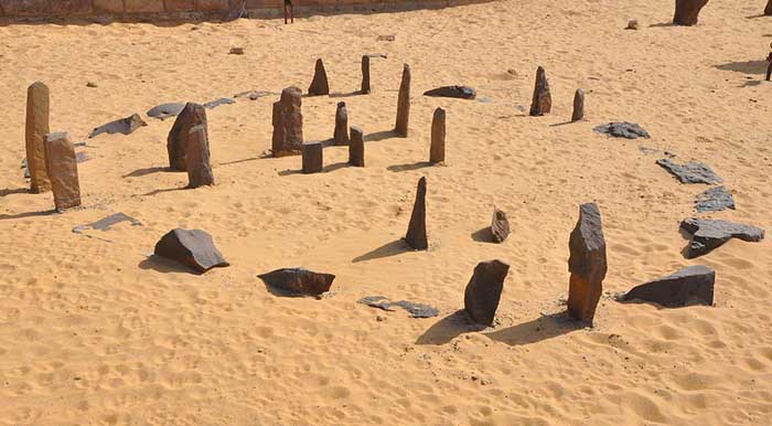
By the 5th millennium BC these peoples had fashioned one of the world's earliest known archeoastronomical devices (roughly contemporary to the Goseck circle in Germany and the Mnajdra megalithic temple complex in Malta), about 1000 years older than but comparable to Stonehenge. Research suggests that it may have been a prehistoric calendar which accurately marks the summer solstice.
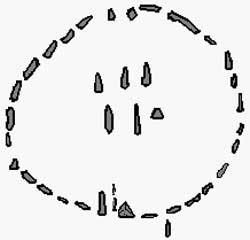
The research done by the astrophysicist Thomas G. Brophy suggests that these monoliths might tell much more. The calendar circle itself is made up of one doorway that runs north-south, a second that runs northeast-southwest marking the summer solstice, and six center stones. Brophy's hypothesis proposes first that the southerly line of three stones inside the calendar circle represented the three stars of Orion's Belt and the other three stones inside the calendar circle represented the shoulders and head stars of Orion as they appeared in the sky. These correspondences were for two dates - circa 4,800 BC and at precessional opposition - representing how the sky "moves" long term. Brophy proposes that the circle was constructed and used circa the later date, and the dual date representation was a conceptual representation of the motion of the sky over a precession cycle.
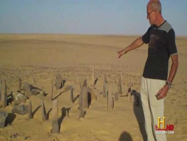
Near by the calendar circle, which is made of smaller stones, there are alignments of large megalithic stones. The southerly lines of these megaliths, Brophy shows, aligned to the same stars as represented in the calendar circle, all at the same epoch, circa 6270 BC. The calendar circle correlation with Orion's belt occurred between 6400 BC and 4900 BC, matching the radio-carbon dating of campfires around the circle.
Brophy found that the lines made to these megaliths match the spots in the sky where the various stars rose in vernal equinox heliacal rising. In analyzing the varying distances, mulling through assumptions such as that they represented the brightness of the stars, he inadvertently found that they matched the distance of the stars from Earth on a scale of roughly 1 meter = .8 light years within the margin of error for astronomical distances calculated today.
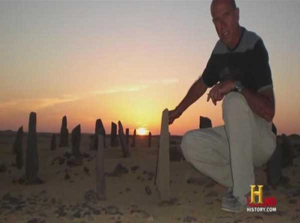
In 1972 a team of archaeologists made such a discovery while traveling through a remote region in southern Egypt. They were navigating by compass through a trackless waste known as the Nabta Playa and had halted for a water break, when they noticed potsherds at their feet. Fragments of old pottery frequently are an indicator of archaeological potential, and the team returned later to investigate. After several seasons of digging they eventually realized that Nabta Playa was not just another neolithic site. The breakthrough came when they discovered that what had looked like rock outcroppings were in fact standing megalithic stones.
In March 1998, a team led by Southern University Methodist Anthropology Prof. Fred Wendorf announced that they had found the megalithic site. The site consists of a stone circle, a series of flat, stone structures and five lines of standing and toppled megaliths. Fred Wendorf, one of the discoverers and a much traveled archaeologist, turned up an abundance of cultural artifacts, which were radiocarbon dated. The ages ranged from 10,000 B.C. to 3,000 B.C., with most of the dates clustered around 6,000 B.C., when the climate was much wetter than now. The Nabta Playa is a basin and during this epoch it filled with seasonal lakes.
Excavations through the 8-12 feet of sediments laid down during this period showed that some of the megaliths had been buried intentionally. The team also found strange carvings in the bedrock under the sediments evidence of great antiquity. The archaeologists mapped the area and used global positioning technology (GPS) to plot the locations of 25 individual megaliths. Many others remain to be plotted. Fortunately, the site's remoteness protected it from most human disturbance. Though the mapping data hinted at astronomical significance, Wendorf's team searched in vain for the key to unlock the site.
In 2001 they presented their research in a book edited by Wendorf, Holocene Settlement of the Egyptian Sahara. The two-volume study makes for interesting reading. But its authors had few answers. In 2002, a former NASA physicist named Thomas Brophy was quietly pursuing his own astronomical study of Nabta Playa. Brophy presented his findings in The Origin Map. Because the available astronomy software was inadequate Brophy had to custom-engineer his own. Thus armed, he was able to track star movements at Nabta Playa over thousands of years, and succeeded in decoding the stone circle and nearby megaliths.
The Calendar Circle has a built-in meridian-line and a sight-line both conspicuous which indicated to Brophy that the circle was a user-friendly star-viewing platform. Its design was so simple that even a novice could have used it. A night viewer between 6400-4900 B.C. stood at the north end of the meridian axis and allowed himself to be guided by three stones at his feet to the constellation Orion overhead. The correspondence between ground and sky would have been self-evident: The three stones within the outer circle are laid out in the precise pattern of the stars of Orion's famous belt, before summer solstice as indicated by the Calendar Circle itself. Once the pattern becomes familiar it is unmistakable.
So, what do the Nabta megaliths tell us after thousands of years of silence? Their designers placed them in straight lines that radiate out from a central point. The arrangement employed a simple star-coordinate system that assigned two stones per star. One aligned with the star itself and marked its vernal equinox heliacal (i.e., rising together with the sun on the first day of spring) position on the horizon. The other aligned with a reference star, in this case Vega, thus fixing the first star's rising at a specific date in history. In archaeoastronomy single megalithic alignments with stars are considered dubious because at any given time several stars will rise at or within a few degrees of the point on the horizon denoted by a lone marker.
Over long periods of time many different stars will rise over this position. The creators of Nabta Playa eliminated uncertainty with the Vega alignment and the specificity of vernal equinox heliacal rising, which occurs only once every 26,000 years for a given star. This fixed the star's rising date. Vega was a logical choice because it is the fifth brightest star in the heavens and dominated the northern sky in this early period. Brophy found that six of the megaliths corresponded with the six important stars in Orion (Alnitak, Alnilam, Mintaka, Betelgeuse, Bellatrix, and Meissa), also confirming his analysis of the nearby circle.
Their placement marked the vernal heliacal rising of these stars, which occurred around 6,300 B.C., within about twenty years. The second set of reference stones were keyed to the heliacal rising of Vega, which occurred at the autumnal equinox. In the seventh millennium B.C. the Nabta plain was a busy place. The heliacal rising of a star occurs when it rises above the horizon with the morning sun.
A vernal heliacal rising describes the same event on the day of the spring equinox, which is much rarer. Using a conservative statistical protocol, Brophy calculated the probability that the megalithic alignments at Nabta were random at less than two chances in a million, which, as he writes is more than a thousand times as certain as the usual three standard deviations requirement for accepting a scientific hypothesis as valid. The only reasonable conclusion is that the star alignments at Nabta Playa were carefully planned - though no accident. Students of the Giza plateau have often remarked that no detail of the famous pyramids was left to chance. Every angle, every relationship, every aspect, had a definite purpose. Brophy merely guessed that the same might hold at Nabta Playa.
Brophy believes information about the relative velocities of stars, and their masses, may also be encoded in the placements. And he thinks that smaller companion stones lying near the base of some of the large megaliths probably represent companion stars, or even planetary systems. Unfortunately, this cannot be tested at present because astronomy is not yet able to observe earth-sized planets across the reaches of space. Rapid strides are being made, however.
A number of Jupiter-sized giants have already been detected and resolving power continues to improve. The location of the star map's central point initially drew the attention of Wendorf's team because a complex structure of megaliths had been placed there. One large stone stood squarely at the central point, surrounded by others. Numerous other stone complexes had also been placed in the vicinity. These appeared to be burial mounds and when the archaeologists excavated two of them the team expected to uncover mortuary remains. Instead, they dug through 12 feet of Holocene sediments to bedrock and found bizarre carved sculptures, which they never did explain.
Brophy realized that whoever created Nabta Playa might have been in possession of advanced knowledge about our Milky Way Galaxy. The bedrock sculpture appears to be a made-to-scale map of the Milky Way as viewed from the outside, i.e., from the perspective of the north galactic pole. The map correctly indicates the position, scale, and orientation of our sun, and the placements of the spiral arms, the galactic center, even the associated Sagittarius dwarf galaxy that was only discovered in 1994. Brophy was able to determine from Wendorf's accurate diagrams/ maps that the central point was directly above and surely represented the correct position of our sun on the galaxy map.
Brophy then made another key discovery -- one of the megalithic sight lines stood in relation to the galactic center. Its alignment marked the galactic center's vernal heliacal rising circa 17,700 B.C.. Amazingly, the orientation of the galactic plane in the sculpture also corresponded with this date. Brophy concluded that the stone sculpture was a map of the Milky Way as seen from the standpoint of the northern galactic pole.

Nabta Playa in Egypt is a mysterious stone circle that may be the world's oldest astronomical observatory Live Science - October 7, 2024
Nabta Playa in Egypt is an ancient stone circle that researchers suspect was used to determine the summer solstice, which signaled rain was on the way. It allegedly was created 7,500 years ago.