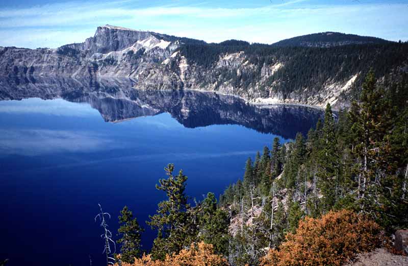
A lake is a body of relatively still water of considerable size, localized in a basin, that is surrounded by land apart from a river, stream, or other form of moving water that serves to feed or drain the lake. Lakes are inland and not part of the ocean and therefore are distinct from lagoons, and are larger and deeper than ponds Lakes can be contrasted with rivers or streams, which are usually flowing. However most lakes are fed and drained by rivers and streams.
Natural lakes are generally found in mountainous areas, rift zones, and areas with ongoing glaciation. Other lakes are found in endorheic basins or along the courses of mature rivers. In some parts of the world there are many lakes because of chaotic drainage patterns left over from the last Ice Age. All lakes are temporary over geologic time scales, as they will slowly fill in with sediments or spill out of the basin containing them.
Many lakes are artificial and are constructed for industrial or agricultural use, for hydro-electric power generation or domestic water supply, or for aesthetic or recreational purposes.
In creation myths and pseudoscience, lakes are sometimes referenced as the place the gods descended to - or emerged from - to create humanity. There is always the message that these gods will return one day.

Dogon Mythology - The Nommo

Amphibious Gods
Many believe there are subterranean alien bases under lakes and oceans. UFO's are seen rising form the water by locals in places such as Lake Titicaca, where legends of ancient astronauts who visited the planet thousands of years ago, are common. USOs - Unidentified Submerged Objects
Divers Found a Lost 600-Year-Old City at the Bottom of a Chinese Lake, and It's Still Remarkably Intact Daily Galaxy - April 22, 2026


A 600-year-old city is sitting almost untouched beneath the waters of Qiandao Lake in eastern China. Known as Shi Cheng, or Lion City, it has been compared to Atlantis because of how well it has survived underwater.
Archaeologists Working of the Northwest Shore of Kyrgyzstan's Lake Issyk-Kul Found an Atlantis-Like Metropolis Hidden Beneath One of Earth's Deepest Lakes Daily Galaxy - April 19, 2026
Beneath a mountain lake's shallow waters, divers found brick streets no one knew existed and a cemetery stretching fourteen acres across the lakebed. The pattern kept reappearing under the shifting sand. Divers working off the northwest shore of Kyrgyzstan's Lake Issyk-Kul would watch currents expose straight lines of fired brick, then heavy stone shapes, then wooden beams lying in the same zones. Natural lakebeds do not arrange themselves that way. In November 2025, an expedition confirmed what the repeating geometry suggested a medieval city sits intact just meters below the surface.
Loughareema: The 'vanishing lake' in Northern Ireland that mysteriously drains and refills itself within hours Live Science - August 29, 2025

Loughareema, or The Vanishing Lake, is an ephemeral lake in Northern Ireland with a rare geology that scientists still don't really understand. Three streams flow into the lake, but the only exit is a drain at the bottom that frequently gets blocked and unblocked, resulting in dramatic changes in the water level.
Unprecedented climate shocks are changing the Great Lakes forever
Extreme heat waves and cold spells on the Great Lakes have more than doubled since the late 1990s, coinciding with a major El Ni�o event. Using advanced ocean-style modeling adapted for the lakes, researchers traced temperature trends back to 1940, revealing alarming potential impacts on billion-dollar fishing industries, fragile ecosystems, and drinking water quality.
Taal Lake on Luzon Island in the Philippines has an island within a lake, within an island within a lake, within an island Live Science - June 20, 2025 Science Daily - August 14, 2025

Lake Tahoe mystery: Why aren't the lake's famous waters getting more clear? PhysOrg - June 17, 2025

The clarity of Lake Tahoe - the famed alpine lake on California's border with Nevada, whose spectacular scenery draws millions of visitors a year and has spawned countless bumper stickers to "Keep Tahoe Blue" - is in the middle of a curious trend. It isn't really getting much better. Or much worse, despite relentless efforts to improve it. And scientists aren't sure why. A new study published by researchers at UC Davis shows that the annual average clarity for Lake Tahoe's azure blue waters in 2024 was 62.3 feet, measured as the depth to which a 10-inch white disk, called a Secchi disk, remains visible when lowered into the water.
Lake Vostok: The 15 million-year-old lake buried miles beneath Antarctica's ice Live Science - February 14, 2025

Buried several miles beneath East Antarctica's ice, Lake Vostok is one of the largest freshwater lakes on Earth, rivaling Lake Ontario in terms of size and volume.
Lake Michigan experiences warmest November in 30 years as climate change heats up the Great Lakes PhysOrg - December 17, 2024
Lake tsunamis are a thing too, and they can be just as devastating - here's everything you need to know about them IFL Science - May 3, 2024

They happen when the sudden displacement of large volumes of water causes waves to form. The phenomenon is becoming increasingly common in places like Alaska and British Columbia, as well as other regions with mountain glaciers. Like ocean tsunamis, which are usually caused by an earthquake below or near the sea floor, lake tsunamis can also result from seismic activity. When lakes lie on or near a fault line, earthquakes can disrupt the lake bed and displace large amounts of water as a tsunami.
What does Lake Washington's warming mean for its future PhysOrg - February 20, 2024
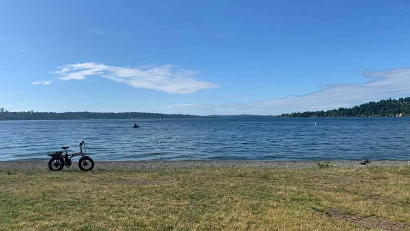
The lake has warmed up earlier in the year and taken longer to cool down in the fall and winter months, which have even shown a modest warming trend. The region's cold, watery heart is nestled between Seattle and the Eastside. It uniquely supports two major roadways atop floating bridges, has offered beachgoers a summertime respite for decades and is central to the identity of the Seattle area's culture.
What does an iceless Lake Superior portend? PhysOrg - February 19, 2024
From Duluth, Lake Superior is a colossal expanse of blue this week with no otherworldly ice shards smashed against the shore or colorful fish houses decorating stretches of white. At about 2%, the amount of ice on the lake is the lowest it has been at this point in recorded history, a phenomenon that is true for the Great Lakes as a whole.
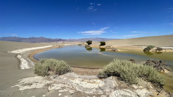
Death Valley's Strange New Lake Has Been Unexpectedly Filling Up Live Science - February 20, 2024
An atmospheric river earlier this month meant Death Valley saw 38 millimeters (1.5 inches) of rain in just three days � it normally only gets 50 millimeters (2 inches) in a year. Some of that water has been draining into the basin, filling up the lake.
Year's Worth Of Rain In Single Day Leaves Death Valley With Incredible Ephemeral Lake IFL Science - October 27, 2023
https://assets.iflscience.com/assets/articleNo/73040/iImg/74319/badwater-basin-l.webp
Park rangers took a boat on the newly created lake, measuring the lowest point at the time to be 0.3 meters (1 foot) deep. The Death Valley National Park team posted on their Facebook page, showing another of the short-lived ephemeral lakes.
Rare lake forms in Death Valley Live Science - October 27, 2023

An oasis teeming with ponds and wildflowers has formed at Death Valley National Park, one of the hottest and driest places in the world, following a major hurricane this summer. Hurricane Hilary, which hit the area in August, provided some much-needed rainfall for the national park, located in eastern California, according to CNN. It is definitely a rare and special event.
Eight Colorado lakes suspected of toxic algae blooms: Why it is becoming worse PhysOrg - August 3, 2023
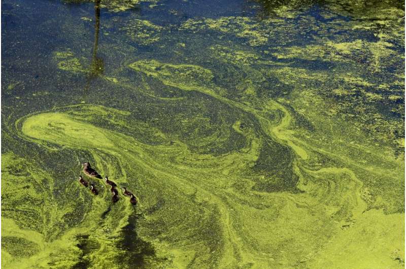
Colorado's lakes serve as a needed respite during sweltering summer days, but as climate warms, the state's lakes are becoming more susceptible to toxic blooms of algae.
The Largest Lake On Earth Once Covered 2.8 Million Square Kilometers IFL Science - April 25, 2023
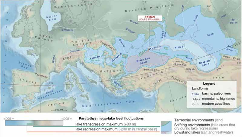
Existing around 34 million years ago, the Paratethys Sea was once the largest lake to ever exist on Earth. This large epicontinental stretch of water reached from today�s Austria to Turkmenistan, along the southern margin of Eurasia, covering an enormous 2.8 million square kilometers (1 million square mile
The number of lakes on our planet has increased substantially in recent decades, according to a unique global survey of 3.4 million lakes Science Daily- November 28, 2022
There has been a particular increase in the number of small lakes, which unfortunately, emit large amounts of greenhouse gas. The development is of great importance for Earth's carbon account, global ecosystems, and human access to water resources.
Climate change is making lakes less blue PhysOrg - September 23, 2022
If global warming persists, blue lakes worldwide are at risk of turning green-brown, according to a new study which presents the first global inventory of lake color. Shifts in lake water color can indicate a loss of ecosystem health.
World's lakes experience excess warming PhysOrg - September 15, 2022
More than half the world's 117 million lakes experience ice cover for part of the year. But with the rise in global temperatures, the timing of seasonal ice formation and loss are changing at rapid rates. Since 1979, the average timing of lake ice break-up across the Northern Hemisphere has advanced by 8 days. This 8-day advancement has resulted in excess lake warming with numerous implications for lake ecosystems.
Arctic lakes are vanishing in surprise climate finding PhysOrg - August 30, 2022
The Arctic is no stranger to loss. As the region warms nearly four times faster than the rest of the world, glaciers collapse, wildlife suffers and habitats continue to disappear at a record pace. Now, a new threat has become apparent: Arctic lakes are drying up.
Race is on to save the Great Salt Lake: Will it be enough? PhysOrg - February 3, 2022
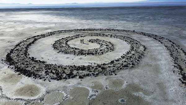
The largest natural lake west of the Mississippi is shrinking past its lowest levels in recorded history, raising fears about toxic dust, ecological collapse and economic consequences.
The Great Salt Lake is the largest saltwater lake in the Western Hemisphere, and the eighth-largest terminal lake in the world. It lies in the northern part of the U.S. state of Utah, and has a substantial impact upon the local climate, particularly through lake-effect snow. It is a remnant of Lake Bonneville, a prehistoric body of water that covered much of western Utah. Read more ...
Our lakes are losing their ice cover faster than ever PhysOrg - December 21, 2021
Every winter when Lake Suwa in Japan freezes, locals believe that the Shinto male god Takeminakata crosses the frozen lake with his dragon to visit the female god Yasakatome. He leaves only his footsteps on the ice in the form of a sinusoidal ice ridge called the omiwatari. In 1397, Shinto priests began celebrating and recording the appearance of the omiwatari. They used the direction of the cracks left by the omiwatari to forecast the agricultural harvest for the upcoming summer. In the first 250 years of the ice record, Lake Suwa froze every year, except for three years during which time the region saw widespread famine. Since the turn of the millennium, however, the lake has only frozen seven times. Lake Suwa is one of many lakes in the Northern Hemisphere that is rapidly losing its ice cover.
Lakes are changing worldwide - lake temperatures are rising and seasonal ice cover is becoming shorter and thinner PhysOrg - October 18, 2021
This affects lake ecosystems, drinking water supply and fishing.
Study shows water hundreds of feet below the surface of Lake Michigan is warming PhysOrg - March 22, 2021
Water hundreds of feet below the surface of Lake Michigan is warming, especially in winter, according to a report published last week by the National Oceanic and Atmospheric Administration. The warming could change the seasonal patterns of the lake - and alter a way of life for ecosystems and industry alike. It's been known that Lake Michigan surface temperatures are increasing and ice cover is lessening as human activity spurs climate change.
Great Lakes continue to rise; Lakes Michigan, Huron likely to top records September PhysOrg - June 10, 2020
Experts predict record-breaking levels this summer as the Great Lakes continue to rise as two of the lakes and Lake St. Clair set new monthly records in May. Lakes Michigan, Huron, St. Clair and Erie broke monthly water level records in May that were previously set in 1986, U.S. Army Corps of Engineers officials said. Lakes Michigan-Huron and St. Clair smashed the all-time high marks by 4 inches, while Lake Erie bested its record by one inch. The same lakes set monthly records in April.
Massive 'lake' discovered under volcano could unlock why and how volcanoes erupt Science Daily - November 8, 2016
A huge magmatic lake has been discovered, 15 kilometers below a dormant volcano in Bolivia, South America. The body of water, which is dissolved into partially molten rock at a temperature of almost 1,000 degrees Celsius, is the equivalent to what is found in some of the world's giant freshwater lakes, such as Lake Superior. The find has now led scientists to consider if similar bodies of water may be 'hiding' under other volcanoes and could help explain why and how volcanoes erupt.
Ancient lake challenges understanding of evolution PhysOrg - May 20, 2015
Scientists have studied samples of lake sediments deposited 1.5 billion years ago in the Bay of Stoer region in north-west Scotland, and discovered high levels of the metal molybdenum, a key element in the evolution of multicellular life. The discovery challenges the commonly held view that an important stage of evolution, leading eventually to human life, occurred in the deep ocean, as opposed to a continental environment.
Periglacial: Part of the lake's margin is formed by an ice sheet, ice cap, or glacier, the ice having obstructed the natural drainage of the land.
Subglacial: A lake which is permanently covered by ice. They can occur under glaciers, ice caps, or ice sheets. There are many such lakes, but Lake Vostok in Antarctica is by far the largest. They are kept liquid because the overlying ice acts as a thermal insulator retaining energy introduced to its underside by friction, by water percolating through crevasses, by the pressure from the mass of the ice sheet above, or by geothermal heating below.
Glacial lake: a lake with origins in a melted glacier.
Artificial: A lake created by flooding land behind a dam, called an impoundment or reservoir; by deliberate human excavation; or by the flooding of an excavation incident to a mineral-extraction operation such as an open pit mine or quarry. Some of the world's largest lakes are reservoirs.
Endorheic, also called terminal or closed: A lake which has no significant outflow, either through rivers or underground diffusion. Any water within an endorheic basin leaves the system only through evaporation or seepage. These lakes, such as Lake Eyre in central Australia or the Aral Sea in central Asia, are most common in desert locations.
Meromictic: A lake which has layers of water which do not intermix. The deepest layer of water in such a lake does not contain any dissolved oxygen. The layers of sediment at the bottom of a meromictic lake remain relatively undisturbed because there are no living aerobic organisms.
Fjord lake: A lake in a glacially eroded valley that has been eroded below sea level.
Oxbow: A lake which is formed when a wide meander from a stream or a river is cut off to form a lake. They are called "oxbow" lakes due to the distinctive curved shape that results from this process.
Rift lake: A lake which forms as a result of subsidence along a geological fault in the Earth's tectonic plates. Examples include the Rift Valley lakes of eastern Africa and Lake Baikal in Siberia.
Underground: A lake which is formed under the surface of the Earth's crust. Such a lake may be associated with caves, aquifers, or spring
Crater: A lake which forms in a volcanic caldera or crater after the volcano has been inactive for some time. Water in this type of lake may be fresh or highly acidic and may contain various dissolved minerals. Some also have geothermal activity, especially if the volcano is merely dormant rather than extinct.
Lava: A pool of molten lava contained in a volcanic crater or other depression. Lava lakes that have partly or completely solidified are also referred to as lava lakes.
Former: A lake which is no longer in existence. Such lakes include prehistoric lakes and lakes which have permanently dried up through evaporation or human intervention. Owens Lake in California, USA, is an example of a former lake. Former lakes are a common feature of the Basin and Range area of southwestern North America.
Seasonal lake: A lake that exists as a body of water during only part of the year.
Shrunken: Closely related to former lakes, a shrunken lake is one which has drastically decreased in size over geological time. Lake Agassiz, which once covered much of central North America, is a good example of a shrunken lake. Two notable remnants of this lake are Lake Winnipeg and Lake Winnipegosis.
Eolic: A lake which forms in a depression created by the activity of the winds.
A lake may be infilled with deposited sediment and gradually become a wetland such as a swamp or marsh. Large water plants, typically reeds, accelerate this closing process significantly because they partially decompose to form peat soils that fill the shallows. Conversely, peat soils in a marsh can naturally burn and reverse this process to recreate a shallow lake.
Turbid lakes and lakes with many plant-eating fish tend to disappear more slowly. A "disappearing" lake (barely noticeable on a human timescale) typically has extensive plant mats at the water's edge. These become a new habitat for other plants, like peat moss when conditions are right, and animals, many of which are very rare. Gradually the lake closes, and young peat may form, forming a fen. In lowland river valleys, where a river can meander, the presence of peat is explained by the infilling of historical oxbow lakes. In the very last stages of succession, trees can grow in, eventually turning the wetland into a forest.
Some lakes can disappear seasonally. These are called intermittent lakes and are typically found in karstic terrain. A prime example of an intermittent lake is Lake Cerknica in Slovenia. Sometimes a lake will disappear quickly. On 3 June 2005, in Nizhny Novgorod Oblast, Russia, a lake called Lake Beloye vanished in a matter of minutes. News sources reported that government officials theorized that this strange phenomenon may have been caused by a shift in the soil underneath the lake that allowed its water to drain through channels leading to the Oka River.
The presence of ground permafrost is important to the persistence of some lakes. According to research published in the journal Science ("Disappearing Arctic Lakes," June 2005), thawing permafrost may explain the shrinking or disappearance of hundreds of large Arctic lakes across western Siberia. The idea here is that rising air and soil temperatures thaw permafrost, allowing the lakes to drain away into the ground.
Neusiedler See, located in Austria and Hungary, has dried up many times over the millennia. As of 2005, it is again rapidly losing water, giving rise to the fear that it will be completely dry by 2010.
Some lakes disappear because of human development factors. The shrinking Aral Sea is described as being "murdered" by the diversion for irrigation of the rivers feeding it.
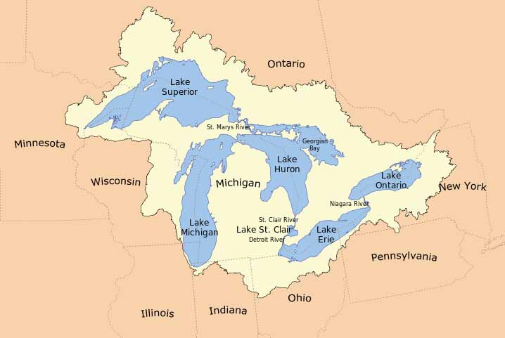
The Great Lakes (sometimes, Laurentian Great Lakes) are a collection of freshwater lakes located in northeastern North America, on the Canada�United States border, which connect to the Atlantic Ocean through the Saint Lawrence Seaway and the Great Lakes Waterway. Consisting of Lakes Superior, Michigan, Huron, Erie, and Ontario, they form the largest group of freshwater lakes on Earth, containing 21% of the world's surface fresh water.
,p>
The total surface is 94,250 square miles (244,106 km2), and the total volume (measured at the low water datum) is 5,439 cubic miles (22,671 km3). The lakes are sometimes referred to as the North Coast or "Third Coast" by some citizens of the United States. They have also been referred to as North America's fourth coast, as traversing the shoreline of each of the lakes covers about 17,000 km (11,000 mi) roughly the distance of almost half the Earth's equator.
The Great Lakes began to form at the end of the last glacial period around 10,000 years ago, as retreating ice sheets carved basins into the land and they became filled with meltwater. The lakes have been a major source of trade through their region, and are home to a large number of aquatic species. Many invasive species have been introduced due to trade in the area, and some threaten the region's biodiversity. Read more ...
Lake Vostok is the largest of Antarctica's almost 400 known subglacial lakes. Lake Vostok is located at the southern Pole of Cold, beneath Russia's Vostok Station under the surface of the central East Antarctic Ice Sheet, which is at 3,488 m (11,444 ft) above mean sea level. The surface of this fresh water lake is approximately 4,000 m (13,100 ft) under the surface of the ice, which places it at approximately 500 m (1,600 ft) below sea level. Measuring 250 km (160 mi) long by 50 km (30 mi) wide at its widest point, and covering an area of 12,500 km2 (4,830 sq mi) and an average depth of 432 m (1,417 ft), it has an estimated volume of 5,400 km3 (1,300 cu mi). The lake is divided into two deep basins by a ridge. The liquid water over the ridge is about 200 m (700 ft), compared to roughly 400 m (1,300 ft) deep in the northern basin and 800 m (2,600 ft) deep in the southern. Read more ...
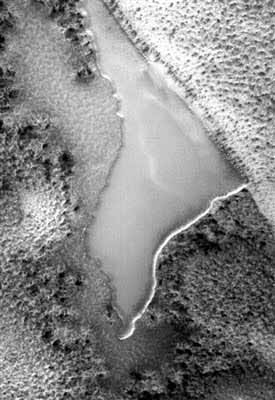
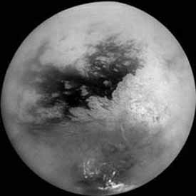
Spring on Saturn's Moon Titan Reveals Amazing Views of Otherworldly Lakes (Photos) Live Science - October 25, 2013
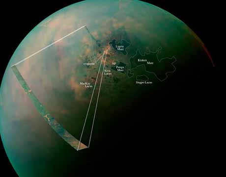
NASA's Cassini space probe is getting an exceptional look at the vast liquid lakes of Titan's north pole, where dense winter clouds are finally retreating thanks to a change in seasons on Saturn's largest moon. A clearer view of Titan's wet northern region could provide clues about the moon's hydrologic cycle and the evolution of its seas. New images released by NASA this week even revealed the Titan equivalent of salt flats surrounding its northern lakes, some of which are as big as the Caspian Sea and Lake Superior combined. Titan more closely resembles Earth than any other planet or moon in our solar system, with a dense atmosphere and stable liquids on its surface. But Titan's clouds, lakes and rain are made up of hydrocarbons, such as ethane and methane, rather than water.
At present the surface of the planet Mars is too cold and has too little atmospheric pressure to permit the pooling of liquid water on the surface. Geologic evidence appears to confirm, however, that ancient lakes once formed on the surface. It is also possible that volcanic activity on Mars will occasionally melt subsurface ice, creating large lakes. Under current conditions this water would quickly freeze and evaporate unless insulated in some manner, such as by a coating of volcanic ash.
Only one world other than Earth is known to harbor lakes, Saturn's largest moon, Titan. Photographs and spectroscopic analysis by the Cassini-Huygens spacecraft show liquid ethane on the surface, which is thought to be mixed with liquid methane.
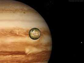
Jupiter's small moon Io is volcanically active due to tidal stresses, and as a result sulfur deposits have accumulated on the surface. Some photographs taken during the Galileo mission appear to show lakes of liquid sulfur on the surface.
There are dark basaltic plains on the Moon, similar to lunar maria but smaller, that are called lacus (singular lacus, Latin for "lake") because they were thought by early astronomers to be lakes of water.