Scott Stones
Scott Stones
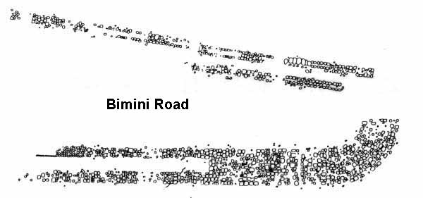
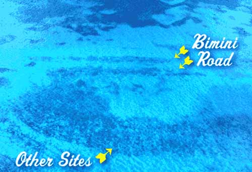
In the Atlantic we find the Bimini Road an underwater rock formation near North Bimini island in the Bahamas. The Road consists of a 0.8 km (0.5 mile) long northeast-southwest linear feature composed of roughly rectangular to sub-rectangular limestone blocks. It most likely belong to an ancient civilization which some believe was once Atlantis.
Over in the Pacific Ocean ... we find this 2022 discovery. An expedition to a deep-sea ridge, just north of the Hawaiian Islands, has revealed an ancient dried-out lake bed paved with what looks like a yellow brick road. The eerie scene was chanced upon by the exploration vessel Nautilus, which is currently surveying the Lili'uokalani ridge within Papahaanaumokakea Marine National Monument
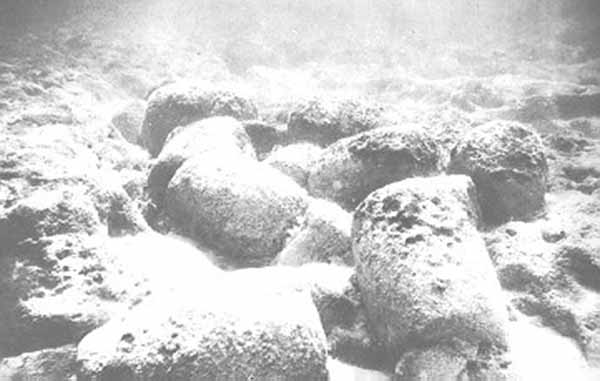
On September 2, 1968, while diving in three fathoms (5.5 meters) of water off the northwest coast of North Bimini island, J. Manson Valentine encountered an extensive pavement of what later was found to be noticeably rounded stones of varying size and thickness.
This stone pavement was found to form a northeast-southwest linear feature, which is most commonly known as either the Bimini Road or Bimini Wall. After Valentine, the Bimini Road has been visited and examined by geologists, avocational archaeologists, professional archaeologists, anthropologists, marine engineers, innumerable divers, and many other people. In addition to the Bimini Road, investigators have found two additional Ňpavement-likeÓ linear features that lie parallel to and shoreward of the Bimini Wall.
The Bimini Wall and two linear features lying shoreward of it composed of flat-lying, tabular, and rectangular, subrectangular, polygonal, and irregular blocks. Descriptions of the Bimini Road found in various books and articles greatly exaggerate the regularity and rectangularity of the blocks comprising these features.
The Bimini Road, the largest of three linear features, is 0.8 km (0.5 mile) long a northeast-southwest trend feature with a pronounced hook at its southwest end. It consists stone blocks measuring as much as 3 to 4 meters (9 to 13 feet) in horizontal dimensions with the average size being 2 to 3 meters (6 to 9 feet).
The larger blocks show complementary edges, which are lacking in the smaller blocks. The two narrower and shorter, approximately 50 and 60 meters (164 and 197 feet) long linear features lying shoreward of the Bimini Road consist of smaller tabular stone blocks that are only 1 to 2 meter (3 to 6 feet) in maximum horizontal breadth. Having rounded corners, the blocks comprising these pavements resemble giant loaves of bread.
The blocks consist of limestone composed of carbonate cemented shell hash that is called beachrock. Beachrock is native to the Bahamas. The highly rounded nature of the blocks forming the Bimini Road indicates that a significant thickness of their original surface has removed by biological, physical, and chemical processes. Given the degree that these blocks have been eroded, it is highly implausible that any original surface features, including any tool marks and inscriptions, would have survived this degree of erosion.
After a very detailed examination of the Bimini Road and the other linear features, Gifford and Ball made the following observations.
2. No evidence exists anywhere over the three features of two courses of blocks, or even a single block set squarely atop another.
3. Not enough blocks lie in the vicinity of the three features to have formed a now-destroyed second course of rocks.
4. Bedrock closely underlies the entire area of the three features (fig. 5), eliminating the possibility of excavations or channels between them.
5. Indications are that the blocks of the inner and middle features have always rested on a layer of loose sand. No evidence was found of the blocks being cut into or founded on the underlying bedrock surface.
6. In areas of the seaward feature where blocks rest directly on the bedrock surface, no evidence was found of regular or symmetrical supports beneath any of the blocks.
7. We saw no evidence on any of the blocks of regular or repeated patterns of grooves or depressions that might be interpreted as tool marks.
8. The inner and middle features are continuous only over a distance of about 50 meters. Though the seaward feature extends several hundred meters farther to the northeast, it too is not well founded or continuous enough to have served as some kind of thoroughfare.
Pictures posted on various web pages of stones alleged to be artificial "wedge stones" and "prop stones" fail as convincing evidence for a second course of stones because they typically smaller in size, do not form a continuous course, and too infrequently lie directly beneath the blocks that form the surface of the Bimini Road. This is not what would be expected of an actual underlying course of manmade masonry.
In addition, early studies of the Bimini Road, i.e. Gifford and Ball and David Zink, report taking numerous samples and cores for examination. In addition, it is safe to presume that a certain number of the innumerable visitors to the Bimini Road have chipped off pieces of it. Scientific sampling and souvenir hunting would have left behind modern "tool marks" on the various blocks comprising the Bimini Road for later investigators to find.
Attempts have been made to determine the age of the Bimini Road using different techniques. These attempts include direct radiocarbon dating of the stones composing the Bimini Road and Uranium-thorium dating of the marine limestone on which the Bimini Road lies.
In 1978, the radiocarbon laboratory operated by the Department of Geology at the University of Miami dated samples from a core collected by E. A. Shinn in 1977 from the Bimini Road. In 1979, Calvert and others[8] reported dates of 2780±70 (UM-1359), 3500±80 (UM-1360), and 3350±90 (UM-1361) from whole rock samples; a date of 3510±70 (UM-1362), from shells extracted from the beachrock core; and dates of 2770±80 (UM-1364) and 2840±70 (UM-1365) from carbonate cementing the beachrock core.
These dates are temporally consistent in that the shells comprising the beachrock core from the Bimini Road dated older than the cement holding them together as beachrock. These dates can be interpreted as indicating that the shells comprising the Bimini Road are, uncorrected for temporal and environmental variations in radiocarbon, about 3,500 years old. Because of time-averaging and other taphonomic factors, a random collection of shells likely would yield a radiocarbon date that is a few hundred years older than when the final accumulation of shells, which were cemented to form beachrock, actually occurred.
The radiocarbon dates from the cement demonstrate the beachrock comprising the Bimini Road formed about 2,800 radiocarbon years ago by the cementation of pre-existing sediments that accumulated about 1,300 years earlier. Compared to the dates from the shells and the cement, it appears that the whole rock dates reflect samples containing varying proportions of shell and cement without any significant contamination by younger radiocarbon.
Both these dates and interpretation are consistent with the detailed research by Davaud and Strasser that concluded that the layer of beachrock comprising the Bimni Road formed beneath the surface of North Bimini Island and was only exposed by coastal erosion about 1,900 to 2,000 years ago.
Proponents of the Bimini Road being a manmade feature argue that these radiocarbon dates are invalid because they were obtained entirely from whole rock samples and subject to contamination from younger carbon.
The background data reported by Calvert and others concerning the radiocarbon dates from the Bimini Road demonstrate that not all of these dates come entirely from whole rock samples.
That the dates from the shells and the clearly younger cement holding them together as beachrock are temporarily consistent argues against any signification alteration of their radiocarbon content. In addition, other studies using radiocarbon dating to study sea level and the age of sediment and beachrock within the Bahamas have not reported any significant problems with contamination by younger radiocarbon.
In their detailed research, Davaud and Strasser accepted the radiocarbon dates obtained from the beachrock comprising the Bimini Road from the radiocarbon laboratory at the University of Miami as valid indicators of its age.
Gifford and Ball attempted to establish a minimum age using Uranium-Thorium dating for the Bimini Road by dating a whole rock sample of the marine limestone (biopelsparite) that underlies the beachrock that comprises the Bimini Road. They described this sample as being "Whole rock marine limestone under beachrock off Paradise Point, North Bimini; some recrystallization." This sample yielded a Uranium-Thorium date of 14,992±258 BP (7132-19/2). Supporters of the idea that the Bimini Road is manmade structure frequently cite this date in support of it being artificial.
The Uranium-Thorium date published by Gifford and Ball is regarded as an invalid and meaningless date for two reasons. First, because the sample is partially recrystallized means that this limestone sample was not a closed system as required for a meaningful Uranium-Thorium date. As a result, this specific date is only an apparent date that completely lacks any scientific value for interpreting the age of marine limestone underlying the age of the Bimini Road.
Currently, specific species of corals and mollusks that can be demonstrated to lack any recrystallization using petrographic and X-ray diffraction techniques are the preferred samples for dating. Currently, any limestone sample that shows the least amount of recyrstallization is now regarded as incapable of yielding a scientifically valid date and not even worth an attempt at dating.
Finally, it is well documented that about 15,000 calendar years ago, sea level in this region was between 95 and100 meters (312 and 330 feet) below present sea level.
As a result, the location from where Gifford and Ball collected the sample of limestone was between 90 and 95 meters (295 and 312 feet) above sea level at the time indicated by the Uranium-Thorium date of 14,992±258 BP (7132-19/2).
Therefore, it is physically impossible for the marine limestone underlying the Bimini Road to have accumulated around 15,000 BP. Thus, this Uranium-Thorium date is a meaningless, invalid date lacking any scientific significance. Because this Uranium-Thorium date clearly lacks any scientific meaning, geologists and archaeologists rarely mention it in their discussions of the Bimini Road. The marine limestone underlying the Bimini Road dates to the Sangamonian Stage, the last interglacial, when sea level was last high enough for the marine sediments, now lithified into limestone, to have accumulated.
The consensus among conventional geologists and archaeologists is that the Bimini Road is a natural feature composed of beachrock that orthogonal and other joints have broken up into rectangular, subrectangular, polygonal, and irregular blocks.
The geologists and anthropologists, who have personally studied the Bimini Road, include Eugene Shinn of the U.S. Geological Survey; Marshall McKusick an Associate Professor of Anthropology at University of Iowa; W. Harrison of Environmental Research Associates, Virginia, Beach Virginia; Mahlon M. Ball and J. A. Gifford of the Rosenstiel School of Marine and Atmospheric Science, University of Miami; and Eric Davaud and A. Strasser of the Department of Geology and Paleontology, University of Geneva, Geneva, Switzerland.
After either inspecting or studying the Bimini Road, they all concluded that it consists of naturally jointed beachrock. John A. Gifford, a professional geologist, spent a significant time studying the geology of the Bimini Islands for his University of Master's thesis about the geology of the Bimini Islands. Calvert and others identified the samples that they dated from the Bimini Wall as being natural beachrock.
Detailed studies by E. Davaud and A. Strasser of Holocene limestones currently exposed on North Bimini and Joulter Cays (Bahamas) reveal the sequence of events likely responsible for creating beachrock pavements like the Bimini Road. First, a complete beach sequence of shallow subtidal, intertidal, and supratidal carbonate sediments accumulated as the shoreline of North Binimi built seaward during part of the Holocene.
Once the deposition of these sediments built the North BiminiŐs shoreline seaward, freshwater cementation of the carbonate occurred at some depth, possible even a meter or so below sea level, beneath the islandŐs surface. This cementation created a band consisting of a thick primary layer of semilithified sediments and thinner discontinuous lenses and layers of similar semilithified sediments beneath it.
Later, when erosion of the islandŐs shoreline occurred, the band of semilithifed sediment was exposed within the intertidal zone and the semilithified sediments was cemented into beachrock. As the sediments underlying the eroding shoreline was eroded down to Pleistocene limestone, the beachrock broke into flat-lying, tabular, and rectangular, subrectangular, polygonal, and irregular blocks as observed for modern beaches within the Bahamas by E. Davaud and A. Strasser.
Thinner layers of beachrock underlying the primary bed of beachrock were also broken up as the loose sediments enclosing them and the thicker primary bed were eroded. As the loose sediment was scoured out from under the blocks and other pieces of beachrock by called 'scour and settling processes', they dropped downward in depth by several meters until they rested directly on the erosion resistant Pleistocene limestone as an erosional lag. Eugene Shinn discusses a similar, but not identical, process by which the Bimini Road could have been created.
The downward movement of large solid objects by scour and settling processes has been documented by Jesse E. McNinch, John T. Wells, and other researchers. They concluded that large heavy objects could sink into the sea bottom by several meters without significant lateral movement as the result of scour and settling processes if an erosion resistant layer of sediment was not encountered. In case of the beachrock blocks comprising the Bimini Road and other pieces underlying it, the erosion resistant layer that limited how far they were dropped downward by scour and settling processes is the Pleistocene limestone on which they now rest.
Finally, pieces of thinner layers or lenses of beachrock underlying the primary bed that was broken up and dropped downward to create the Bimini Road would be trapped beneath the blocks as they also where broken up and dropped by erosion.
The trapping of these fragments of beachrock beneath the blocks comprising the Bimini Road as erosion removed loose sediments and dropped them on the surface of the Pleistocene limestone the blocks of the Bimini Road on top of them would have created the so-called 'prop' and 'wedge' rocks and blocks alleged to be a 'second course' of masonry.
Presuming that the blocks of beachrock forming the Bimini Road originally formed at some unknown depth below sea level and have been dropped by erosion by several meters, dating the age of the Bimini Road by its relation to past sea level would be a useless dating technique that will produce misleading results.
Natural pavements composed of stone blocks, which often are far more rectangular and consistent in size than the blocks composing the Bimini Road, created by orthogonal and other jointing within sedimentary rocks, including beachrock, are quite common and found throughout the world.
They include a popular tourist attraction, the Tessellated pavement of Eaglehawk Neck, Tasmania; jointed bedrock that has been completely misidentified as a manmade "Phoenician Fortress and Furnace" in Oklahoma; a Ňtiled pavementÓ reported from Battlement Mesa in western Colorado; the tesselated pavement of the Bouddi Peninsula near Sydney, Australia; and Arches National Monument in Utah.
Natural beachrock pavements that are identical to the Bimini Road have been found eroding out of the east shore of Loggerhead Key of Dry Tortugas and submerged beneath 90 meters of water at Pulley Ridge off the southwest coast of Florida.
According to Ancient Alien Theory Atlantis is a submerged city built hundreds of thousands of years ago by aliens who visited the planet.
Although it is generally considered to be a naturally occurring geological feature, as a result of the unusual arrangement and shape of the stones some believe the formation is the remains of an ancient road, wall, or some other deliberately constructed feature.
For example articles published in Argosy (an American pulp magazine) and either authored or coauthored by Robert F. Marx, a professional diver and visitor to the Binimi Road, argued that the Bimini Road is an artificial structure.
In the 1971 Argosy article, Robert Marx reported that Dr. Carl H. Holm, who was President, not "head geologist" as reported by Marx, of Global Oceanic; once a manager for North American Rockwell; a ship designer; and retired naval officer stated that there was "little doubt" that the massive stone blocks were cut by people.
The same article noted that he was part of an expedition sponsored by North American Rockwell that included Edgar Mitchell, the astronaut, as leader; Dimitri Rebikoff; and "a number of psychics from the Edgar Cayce Foundation."
Given the complete lack of citations to this research in GeoRef, JSTOR, Web of Knowledge, and other scientific bibliographic databases, neither the data collected from nor the interpretations and conclusions made as a result of this expedition very likely have been publicly reported in a scientific venue where their credibility can be openly evaluated.
Others who consider the Bimini undersea formation to be man-made, as opposed to natural beachrock, are Joseph Manson Valentine, zoologist, Charles Berlitz, linguist, Gregory Little, psychologist, R. Cedric Leonard, anthropologist, and Dimitri Rebikoff, French marine engineer.
All claim to have investigated the ruins in person, and claim to have observed more than one horizontal layer of blocks, at least in places. However, multiple layers of block can result naturally from systematic fracturing of sedimentary where multiple layers of sedimentary lie on top of each as can be observed in case of the tessellated pavement of Tasmania exposed at the Eaglehawk Neck on the Tasman Peninsula.
Friday, July 14, 2006, the Syfy Channel aired a two-hour special, "Declassified: Quest for Atlantis: Startling New Secrets." It featured the research of 3 teams of respected archaeologists and explorers, in different parts of the world, who truly believe that have located Atlantis and are presenting new evidence to support their theories.
Host Natalie Morales, an NBC correspondent, joined the teams on a first attempt to pull all of the pieces together using high tech science, historical research and paranormal powers to answer the question ... Did Atlantis actually exist? This is a good insert to move consciousness forward. The quest to find Atlantis is the quest to find the truth about our origins.
Science and metascience are merging ... At last, At-lantis ... the grid programs understood. Science and technology, growing awareness, raising frequency of thought and consciousness, time appearing to move faster while it is actually slowing down to zero point, are allowing us to rediscover the 'mission feeling' and our ancestral roots.
Many topics were covered during the program. Here are a few highlights.
The program explored the work of Zecharia Sitchin, which goes to ancient astronauts and archaeological discovered across the globe that tell the story of humanity.
Author and alternative historian, Michael Tsarion, gave his theories that go to the grid story of aliens coming to Earth after their planet was destroyed about 50,000 years ago. They are portrayed as both grays and humanoids. He believes they interfered with the indigenous populations on this planet as part of a biogenetic experiment, breeded with them. Many people have spun this tale.
Science :: About 30,000 years ago, humans began a rapid unexplained advance in all areas. This reflects new inserts in the program. Again we go to DNA codes and reality as a biogenetic experiment. We are getting there.
Take our own reality, for example, why now, in this timeline, is science and human consciousness advancing so rapidly. Why not 200 years ago or earlier? It all goes to the program creating grids of experience that correlate with its countdown to zero point or the evolution of the program back to its origins.
No program, TV or otherwise, would be complete without the Nazi grid program and its quest to find Atlantis and create a race of humans with the same genetic markers, biogenetic program experiment metaphors.
It was noted on the show that through the years people have placed Atlantis in at least 20 areas around the world. There are many others, Possible Atlantis Locations
Stone anchors currently found in the Mediterranean, off Greece, match those uncovered from the Bimini Road. (Greek/Egyptian Programs)
What if there was no Atlantis? What if this speaks to us about planet Earth as one land mass, a giant game board, if you will, in which souls experience?
Researchers on the TV program ...
Edgar Cayce predicted that Atlantis would rise again in 1969. In that time frame the Bimini Road was discovered in the Atlantic Ocean. Most of Edgar Cayce's life readings for his clients were assigned to past lives from 'twelve' main periods including Atlantis, ancient Egypt at the time of "Ra Ta".
American explorer Robert Sarmast, who in 2002 discovered an underwater formation fifty miles off the coast of Cyprus while using side scan sonar, continues his search for Atlantis near the Straits of Gibraltar.
In Antarctica, Argentine explorer Alex Chionetti sets forth and follows through on his theories that Antarctica was once located closer to the equator, which goes to continental drift and Earth Changes
Morales and the researchers explored Plato's writings concerning the plans for world domination by the Atlanteans who became corrupt with power and knowledge, which led to the destruction of Atlantis. One researcher noted how our unfolding reality parallels that of Atlantis at the time of destruction, an old theory for us metaphysical researchers, parallel grids one above to allow us to tap into the future.
Most people who feel their Atlantean connections, are more interested in the spiritual aspects of Atlantis priest and priestesses, healers and teachers, the end of that program, flood stories, information hidden in crystals, crystal caves (mind), passed down to those of a special bloodline, perhaps alien/Atlantean in origin, biogenetic experiments done on humans, awakening now out of the blue (frequency), as we shift consciousness to another program in blue light. Either you understand this by now, or just keep on exploring until you do.
Scientists Found a 'Yellow Brick Road' at The Bottom of The Pacific Ocean Science Alert - November 4, 2024
An expedition to a deep-sea ridge, just north of the Hawaiian Islands, revealed a surprise discovery back in 2022: an ancient dried-out lake bed paved with what looks like a yellow brick road.
ANCIENT AND LOST CIVILIZATIONS