

The Grand Canyon is the second largest canyon in the world - The Tsangpo Canyon in Tibet is actually deeper and longer than the Grand Canyon.
The Grand Canyon is a steep-sided canyon carved by the Colorado River in the United States in the state of Arizona. It is contained within and managed by Grand Canyon National Park, the Hualapai Tribal Nation, and the Havasupai Tribe. President Theodore Roosevelt was a major proponent of preservation of the Grand Canyon area, and visited it on numerous occasions to hunt and enjoy the scenery. It is considered one of the Seven Natural Wonders of the World.
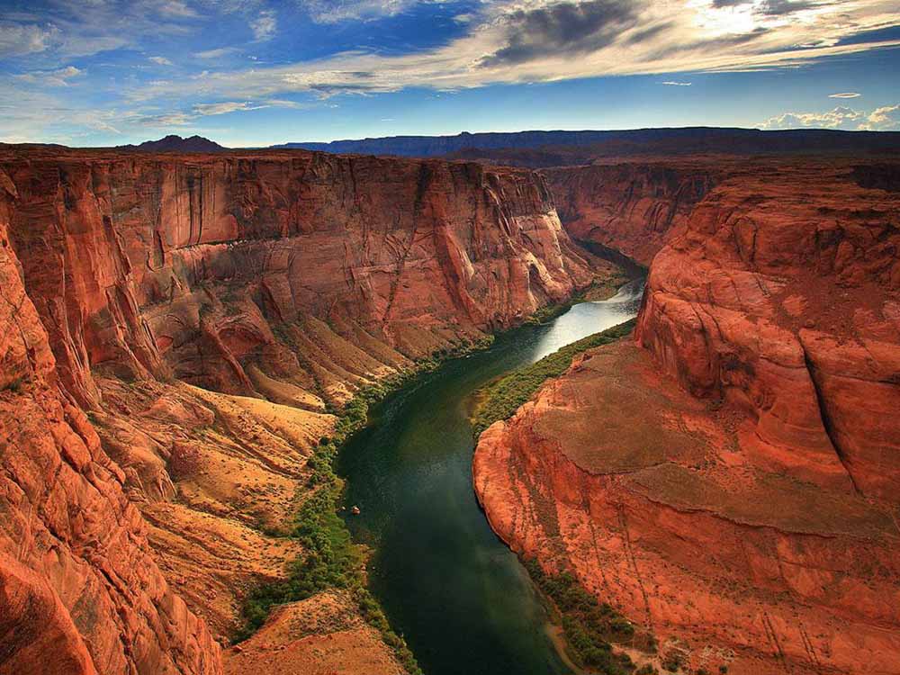
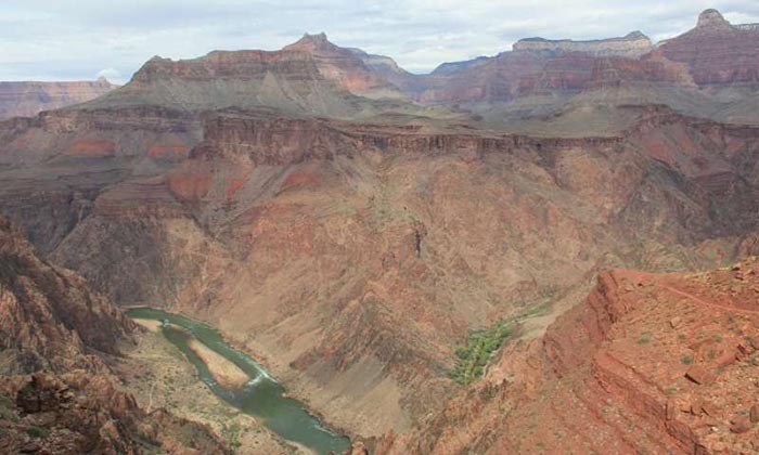
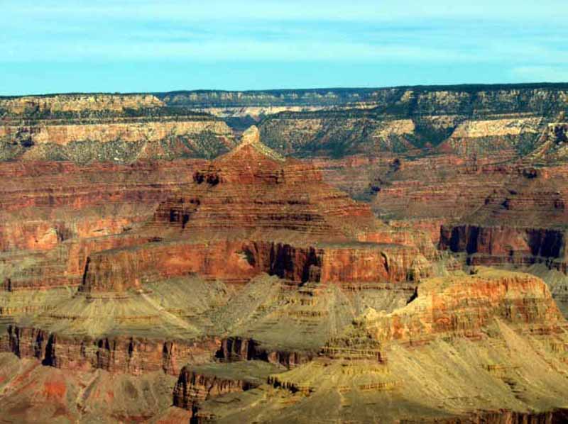
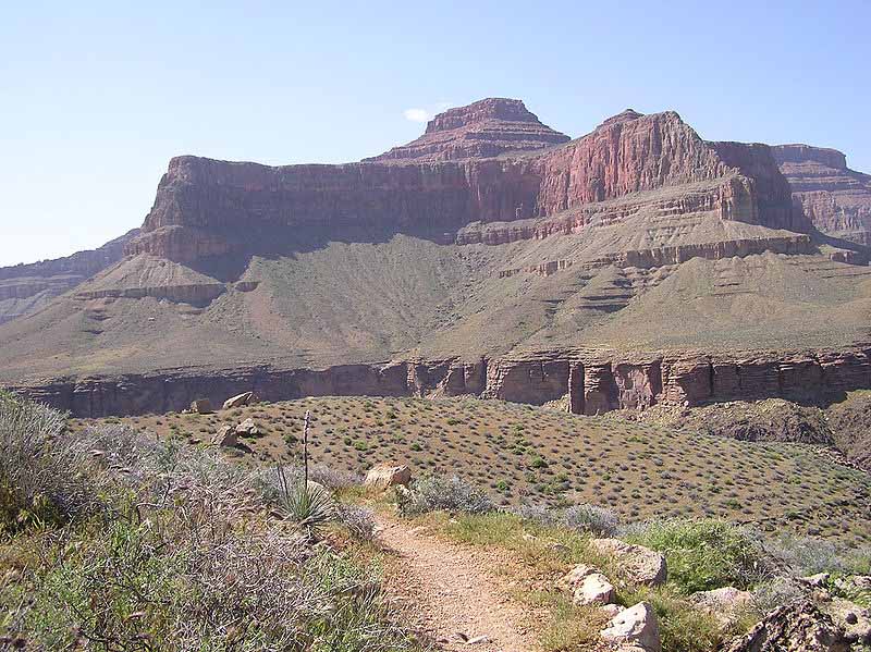
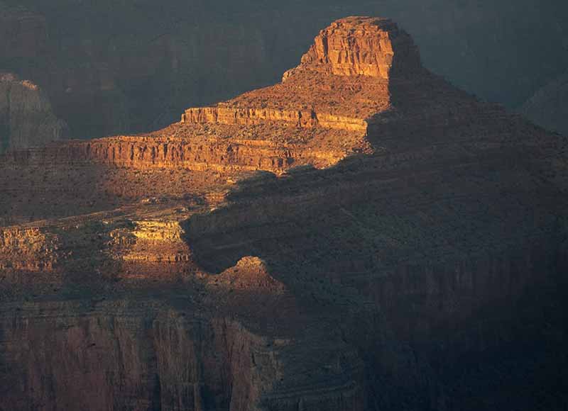
The Grand Canyon is 277 miles (446 km) long, up to 18 miles (29 km) wide and attains a depth of over a mile (6,000 feet / 1,800 metres) Nearly two billion years of the Earth's geological history has been exposed as the Colorado River and its tributaries cut their channels through layer after layer of rock while the Colorado Plateau was uplifted. While the specific geologic processes and timing that formed the Grand Canyon are the subject of debate by geologists, recent evidence suggests the Colorado River established its course through the canyon at least 17 million years ago. Since that time, the Colorado River continued to erode and form the canyon to its present-day configuration.
For thousands of years, the area has been continuously inhabited by Native Americans who built settlements within the canyon and its many caves. The Pueblo people considered the Grand Canyon ("Ongtupqa" in Hopi language) a holy site and made pilgrimages to it.
The first European known to have viewed the Grand Canyon was Garcia Lopez de Cardenas from Spain, who arrived in 1540.
The secret underground system keeping the Grand Canyon alive Science Daily - June 2, 2026

Water comes from a single source: Roaring Springs, a cave-fed spring on the North Rim. Although hikers can hear and glimpse the spring from the North Kaibab Trail, there is no trail leading directly to it. Roaring Springs provides water not only for park visitors but also for the plants, animals, and ecosystems that depend on it. As the region becomes hotter and drier, protecting this vital water source is becoming increasingly important.
Fossil discovery in the Grand Canyon reveals a sea world teeming with strange prehistoric life The Brighterside - August 22, 2025

More than half a billion years ago, the Grand Canyon was not the arid landscape we know today but a shallow, tropical sea teeming with strange life. More than half a billion years ago, the Grand Canyon was not the arid landscape we know today but a shallow, tropical sea teeming with strange life. Now, scientists have uncovered a remarkable fossil record from this ancient world that is rewriting what we know about early animal evolution.
Bizarre ancient creatures unearthed in the Grand Canyon Science Daily - August 14, 2025

A groundbreaking fossil discovery in the Grand Canyon has unveiled exquisitely preserved soft-bodied animals from the Cambrian period, offering an unprecedented glimpse into early life more than 500 million years ago. Researchers uncovered molluscs, crustaceans, and exotic worms with remarkable feeding adaptations, preserved in a nutrient-rich “Goldilocks zone” that fueled evolutionary experimentation. The find not only reveals the complexity of Cambrian ecosystems but also draws intriguing parallels between ancient biological innovation and modern economic risk-taking. A new species of priapulids, also known as penis or cactus worms, which were widespread during the Cambrian but are nearly extinct today.
Two of Arizona's most famous landmarks may be linked by cosmic violence: the asteroid that gouged out Meteor Crater may have also caused the formation of an ancient lake in the Grand Canyon Science Alert - July 23, 2025

Two of Arizona's most famous landmarks may be linked by cosmic violence: the asteroid that gouged out Meteor Crater may have also caused the formation of an ancient lake in the Grand Canyon. This surprising connection between Arizona's world-renowned geological features stretches back 56,000 years, to when a 300,000 ton nickel-iron asteroid slammed into the Colorado Plateau with the force of over 150 atomic bombs, creating the largest meteor crater in the United States. The resultant impact-generated earthquake may have caused a rockslide in the Grand Canyon, damming the Colorado River and temporarily creating a body of water 80 kilometers (50 miles) long and more than 100 meters (around 370 feet) deep in what is today Nankoweap canyon.
Stunning Grand Canyon Fossils Reveal Evolution's Weird Experiments Science Alert - July 23, 2025

A stunning new fossil find from the Grand Canyon fills in some blanks from a time when evolution began experimenting with weird new forms. About half a billion years ago, life on Earth really started cooking in an event we now call the Cambrian explosion. The fossil record from that time reveals a spike in bizarre, complex creatures appearing within a relatively short amount of time, laying the roots for most of the major animal groups that exist today. Frustratingly, fossils from later in the Cambrian period are rarer, so we don't have a clear picture of evolution's experimental second album. But a newly discovered batch of extremely well-preserved fossils could patch up that gap. These are about 505 million years old – 3 million years younger than the Burgess Shale, the layer in which fossils from the Cambrian explosion appear.

'Heart-breaking': Locals and visitors devastated by loss of Grand Canyon Lodge BBC - July 14, 2025
Grand Canyon Dragon wildfire burns down historic lodge and triggers toxic gas leak Live Science - July 14, 2025
Wildfire destroys a historic Grand Canyon lodge and other stores and structures CNN - July 14, 2025
Part of Grand Canyon evacuated as wildfire spreads PhysOrg - July 12, 2025
Study finds link between Grand Canyon landslide and Meteor Crater impact PhysOrg - July 15, 2025

An article, titled "Grand Canyon landslide‐dam and paleolake triggered by the Meteor Crater impact at 56 ka," highlights the striking coincidence in the geologic ages of a meteor impact and a landslide dam that blocked the Colorado River, forming a paleolake in the Grand Canyon about 56,000 years ago.
Geologists rewrite textbooks with new insights from Cambrian rocks of Grand Canyon PhysOrg - November 9, 2024

Since soon after our planet formed, Earth's 4.6 billion-year-long history was dominated by single-celled life. Something dramatic happened about 500 million years ago called the Cambrian "explosion," during which an incredible diversity of life forms became preserved in the rock record. These fossils included major groups of diverse animals that evolved into animal groups still living today (including humans).
Ancient Rock Art Is Scattered Throughout The Grand Canyon - But You'll Never Know Where IFL Science - July 23, 2024
The Grand Canyon is a spectacular sight to behold in and of itself, but did you know the surrounding national park is also home to a wealth of prehistoric rock art? Don't be disappointed if you didn't - the exact whereabouts of the vast majority of it remains a closely guarded secret. Take Shamans' Gallery, a site that most people would never have heard of were it not for word-of-mouth and later, the Internet. First recorded in 1987 and named by American archaeologist Polly Schaafsma, it features a large panel of rock art paintings - called pictographs - depicting anthropomorphic characters, deer, birds, and other abstract features.
Its style has been described as Grand Canyon or Esplanade Polychrome, the latter after the distinctively red and tan bed of sandstone that forms the canyon and though it can be difficult to precisely date rock art, it’s estimated to date back to the Archaic period, which lasted from around 8500 BCE to roughly 2000-1000 BCE.
Geologists dig into Grand Canyon's mysterious gap in time that covers hundreds of millions of years PhysOrg - August 19, 2021
Huge Open Buckets of Uranium Ore Found at Grand Canyon? Totally Fine, Experts Say. Live Science - February 21, 2019
For nearly 20 years, a trio of 5-gallon (19 liters) paint buckets sat near the taxidermy exhibit at Grand Canyon National Park's museum collections building. Those buckets, it turns out, weren't holding paint - they were actually loaded up with uranium ore, a naturally occurring rock rich in uranium that gives off potentially dangerous radiation.
Stunning Views of Grand Canyon National Park Live Science - February 20, 2019
It is not the widest nor longest nor deepest canyon in the world, but the Grand Canyon of northern Arizona is certainly one of the most impressive and most visited natural wonders found on the planet. Photographs, no matter how spectacular, cannot capture nor prepare one for the awe-inspiring sight of viewing the immensity of this canyon for the first time. Neophytes to the canyon have been known to shed an emotional tear as they initially stand in awe before its colossal grandeur. Fortunately for all mankind, early political leaders saw its limitless natural value to science and the soul of mankind and preserved this special grand place of earth as a national park 100 years ago, on Feb. 26, 1919.
Tiny footprints, big discovery: Reptile tracks oldest ever found in grand canyon PhysOrg - November 9, 2018
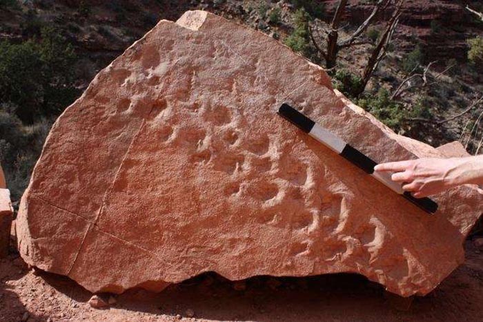
A geology professor at the University of Nevada, Las Vegas, has discovered that a set of 28 footprints left behind by a reptile-like creature 310 million years ago, are the oldest ever to be found in Grand Canyon National Park. The fossil trackway covers a fallen boulder that now rests along the Bright Angel Trail in the national park. It's the oldest trackway ever discovered in the Grand Canyon in an interval of rocks that nobody thought would have trackways in it, and they're among the earliest reptile tracks on earth.
Cambrian Sixty-mile Formation of Grand Canyon yields new findings PhysOrg - June 2, 2018
Nearly five decades ago, in the late 1970s, was the last time a new formation was discovered and defined in the Grand Canyon with the discovery of the Surprise Canyon Formation. Now, a team of scientists have studied one of the last Grand Canyon strata to be dated - the SixtyMile Formation.

I've visited Arizona many times having family there - and on various adventures - but the closest I came to the Grand Canyon was flying over it with a pilot on her private plane. The Grand Canyon is more breathtaking from above.
Looking down took me to childhood memories of visiting the planet in the beginning - when another version of myself - looking much like my Anunnaki persona - had the ability to fly. Landing atop a mountain somewhere - I remember looking down at a planet as it emerged from the chaos of creation in the blink of an eye.
July 2025 - With all the ongoing notoriety about UFO (UAP) sightings in the US - it stands to reason that the Grand Canyon might be a 'hotspot' that perhaps hosts underground bases - with access points through portals that humans have speculated about for centuries or longer.
With rock formations being suggested as portals to underground worlds - we go to pareidolia, or scrying, a subjective way of defining abstract images - in this case viewing natural land formations - as something else. This not only applies to the Grand Canyon but other megalithic monuments on Earth, the Moon, Mars, and beyond ...
The Grand Canyon has a rich history of rock art, including both petroglyphs (carved or etched images) and pictographs (painted images). These art forms are found throughout the canyon, including in the main corridor and side canyons. The art is attributed to various ancestral groups who lived in the area, with some dating back thousands of years.
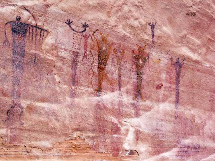
Does this rock art depict Ancient Alien Visitors?

G. E. Kinkaid believed himself to be the first white person born in Idaho. He was an explorer and hunter all his life, working thirty years for the Smithsonian Institute. Below are excerpts from his journal of his alleged adventures in the cave.
This cliff face is purported to be the location of the cave entrance to the mysterious underground citadel.

The entrance is 1,486 feet down the sheer canyon wall. Above a shelf which hid it from view from the river, was the mouth of the cave. There are steps leading from this entrance some thirty yards to what was at the time the level of the river.
When I saw the chisel marks on the wall inside the entrance, I became interested. Securing my gun, I went in.
I gathered a number of relics, which I carried down the Colorado to Yuma, from whence I shipped them to Washington with details of the discovery. Following this, other explorations were undertaken. So interested have the scientists become, that preparations are being made to equip our camp for extensive studies, the number of archaeologists increasing to from 30 to 40.
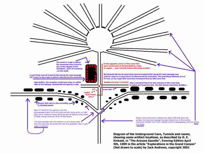
From the long main passage, another mammoth chamber has been discovered from which radiates scores of passageways, like the spokes of a wheel.
Several hundred rooms have been discovered, reached by passageways running from the main passage, one of them having been explored for 854 feet and another 634 feet. The recent finds include articles which have never been known as native to this country, and doubtless they had their origin in the orient. War weapons, copper instruments, sharp-edged and hard as steel, indicate the high state of civilization reached by these people.
The main passageway is about 12 feet wide, narrowing to nine feet toward the farther end. About 57 feet from the entrance, the first side-passages branch off to the right and left, along which, on both sides, are a number of rooms about the size of ordinary living rooms of today, though some are 30 by 40 feet square. These are entered by oval-shaped doors and are ventilated by round air spaces through the walls into the passages. The walls are about three feet six inches in thickness.
The passages are chiseled or hewn as straight as could be laid out by an engineer. The ceilings of many of the rooms converge to a center. The side-passages near the entrance run at a sharp angle from the main hall, but toward the rear they gradually reach a right angle in direction.
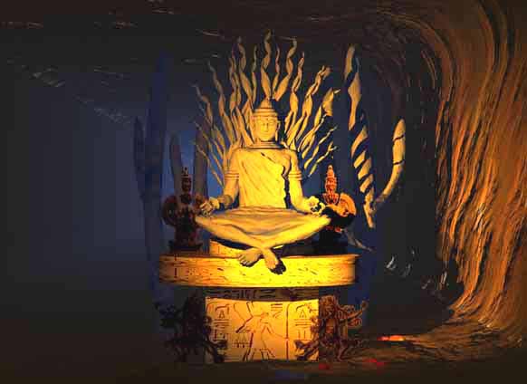
Over a hundred feet from the entrance is the cross-hall, several hundred feet long, in which are found the idol, or image, of the people's god, sitting cross-legged, with a lotus flower or lily in each hand. The cast of the face is oriental. The idol almost resembles Buddha, though the scientists are not certain as to what religious worship it represents. Taking into consideration everything found thus far, it is possible that this worship most resembles the ancient people of Tibet.
Surrounding this idol are smaller images, some very beautiful in form, others crooked-necked and distorted shapes, symbolical, probably, of good and evil. There are two large cactus with protruding arms, one on each side of the dais on which the god squats. All this is carved out of hard rock resembling marble.
In the opposite corner of this cross-hall were found tools of all descriptions, made of copper. These people undoubtedly knew the lost art of hardening this metal, which has been sought by chemicals for centuries without result.
On a bench running around the workroom was some charcoal and other material probably used in the process. There is also slag and stuff similar to matte, showing that these ancients smelted ores, but so far no trace of where or how this was done has been discovered, nor the origin of the ore.
Among the other findings are vases or urns and cups of copper and gold, very artistic in design. The pottery work includes enameled ware and glazed vessels.
Another passageway leads to granaries such as are found in the oriental temples. They contain seeds of various kinds. One very large storehouse has not yet been entered, as it is twelve feet high and can be reached only from above.
Two copper hooks extend on the edge, which indicates that some sort of ladder was attached. These granaries are rounded, as the materials of which they are constructed, I think, is a very hard cement. A gray metal is also found in this cavern, which puzzles the scientists, for its identity has not been established. It resembles platinum. Strewn promiscuously over the floor everywhere are what people call "cats eyes', a yellow stone of no great value. Each one is engraved with the head of the Malay type.
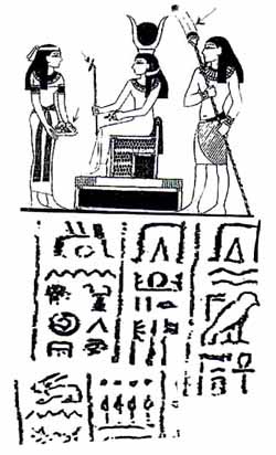
Carved on all the urns, over doorways, and tablets of stone, are mysterious hieroglyphics, the key to which the Smithsonian Institute hopes to discover. The engravings on the tablets probably has something to do with the religion of the people. Similar hieroglyphics have been found in southern Arizona.
Among the pictorial writings, only two animals are found - one of them looking prehistoric.
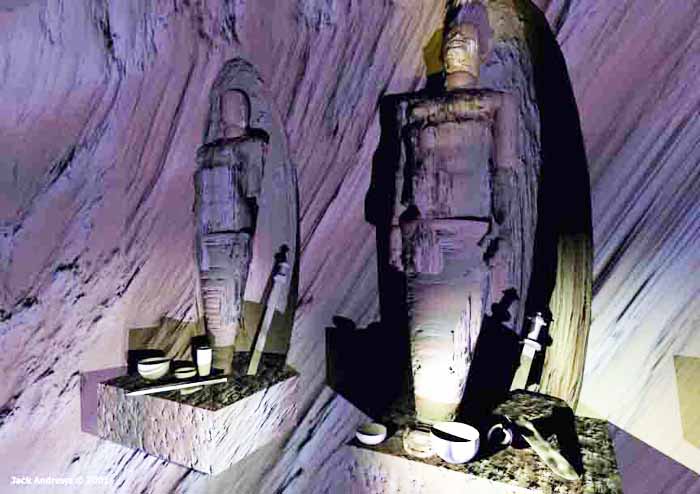
The tomb or crypt in which the mummies were found is one of the largest of the chambers, the walls slanting back at an angle of about 35 degrees. On these are tiers of mummies, each one occupying a separate hewn shelf. At the head of each is a small bench, on which is found copper cups and pieces of broken swords. Some of the mummies are covered with clay and all are wrapped in a bark fabric.
The urns or cups on the lower tiers are crude, while as the higher shelves are reached, the urns are finer in design, showing a later stage of civilization. It is worthy of note that all the mummies examined so far have proved to be male, no children or females being buried here. This leads to the belief that this exterior section was the warriors' barracks.
Among the discoveries no bones of animals have been found, no skins, no clothing, no bedding. Many of the rooms are bare but for water vessels.
One room, about 40 by 700 feet, was probably the main dining hall, for cooking utensils are found here. What these people lived on is a problem, though it is presumed that they came south in the winter and farmed in the valleys, going back north in the summer.
Upwards of 50,000 people could have lived in the caverns comfortably. One theory is that the present Indian tribes found in Arizona are descendants of the serfs or slaves of the people who inhabited the cave.
Undoubtedly a good many thousands of years before the Christian era, a people lived here which reached a high stage of civilization. The chronology of human history is full of gaps.
One thing I have not spoken of, may be of interest. There is one chamber of the passageway which is not ventilated, and when we approached it a deadly, snaky smell struck us. Our light would not penetrate the room, and until stronger ones are available we will not know what the chamber contains. Some say snakes but others think it may contain a deadly gas or chemicals used by the ancients. No sounds are heard, but it smells snaky just the same.
The whole underground installation gives one of shaky nerves the creeps. The gloomy feeling is like a weight on one's shoulders, and our flashlights and candles only make the darkness blacker. Imagination can revel in conjectures and ungodly daydreams back through the ages that have elapsed till the mind reels dizzily in space.
Were ancient civilizations forced to live in caves below the Grand Canyon due to climate change, disease, or something else? Did extraterrestrials create dwellings inside the Grand Canyon caves? To date, there is no tangible proof to support these claims.
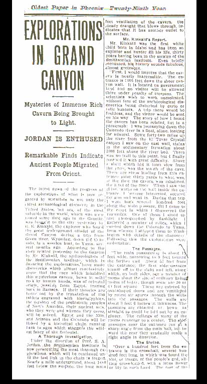
One of the most suppressed stories of all time is the excavation of an Egyptian tomb in Arizona - by the Smithsonian Institute. A lengthy front page story of the Phoenix Gazette on April 5, 1909, gave a highly detailed report of the discovery and excavation of a rock-cut vault by an expedition led by a Professor S.A. Jordan of the Smithsonian. The Smithsonian, however, claims to have absolutely no knowledge of the discovery or its discoverers.
The World Explorers Club decided to check on this story by calling the Smithsonian in Washington, D.C., though we felt there was little chance of getting any real information. After speaking briefly to an operator, we were transferred to a Smithsonian staff archaeologist, and a woman's voice came on the phone and identified herself.
I told her that I was investigating a story from a 1909 Phoenix newspaper article about the Smithsonian Institution's having excavated rock-cut vaults in the Grand Canyon where Egyptian artifacts had been discovered, and whether the Smithsonian Institution could give me any more information on the subject.
She said, "The first thing I can tell you, before we go any further, is that no Egyptian artifacts of any kind have ever been found in North or South America. Therefore, I can tell you that the Smithsonian Institute has never been involved in any such excavations."
She was quite helpful and polite but, in the end, knew nothing. Neither she nor anyone else with whom I spoke could find any record of the discovery or either G.E. Kinkaid and Professor S.A. Jordan. While it cannot be discounted that the entire story is an elaborate newspaper hoax, the fact that it was on the front page, named the prestigious Smithsonian Institution, and gave a highly detailed story that went on for several pages, lends a great deal to its credibility.
It is hard to believe such a story could have come out of thin air. If this story is true it would radically change the current view that there was no transoceanic contact in pre-Columbian times, and that all American Indians, on both continents, are descended from Ice Age explorers who came across the Bering Strait.
Is the idea that ancient Egyptians came to the Arizona area in the ancient past so objectionable and preposterous that it must be covered up? Perhaps the Smithsonian Institution is more interested in maintaining the status quo than rocking the boat with astonishing new discoveries that overturn previously accepted academic teachings. Historian and linguist Carl Hart, editor of Word Explorer, then obtained a hiker's map of the Grand Canyon from a bookstore in Chicago.
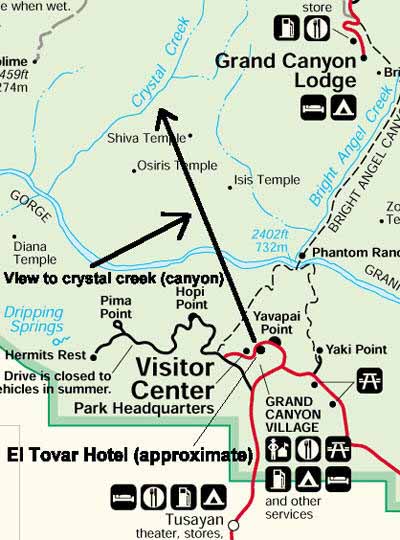
Pouring over the map, we were amazed to see that much of the area on the north side of the canyon has Egyptian names. The area around Ninety-four Mile Creek and Trinity Creek had areas (rock formations, apparently) with names like Tower of Set, Tower of Ra, Horus Temple, Osiris Temple, and Isis Temple.
In the Haunted Canyon area were such names as the Cheops Pyramid, the Buddha Cloister, Buddha Temple, Manu Temple and Shiva Temple. Was there any relationship between these places and the alleged Egyptian discoveries in the Grand Canyon?
This entire area with the Egyptian and Hindu place names in the Grand Canyon is a forbidden zone - no one is allowed into this large area. We could only conclude that this was the area where the vaults were located. Yet today, this area is curiously off-limits to all hikers and even, in large part, park personnel. We called a state archaeologist at the Grand Canyon, and were told that the early explorers had just liked Egyptian and Hindu names, but that it was true that this area was off limits to hikers or other visitors, because of dangerous caves.
I believe that the discerning reader will see that if only a small part of the "Smithsoniangate" evidence is true, then our most hallowed archaeological institution has been actively involved in suppressing evidence for advanced American cultures, evidence for ancient voyages of various cultures to North America, evidence for anomalistic giants and other oddball artifacts, and evidence that tends to disprove the official dogma that is now the history of North America. The Smithsonian's Board of Regents still refuses to open its meetings to the news media or the public. If Americans were ever allowed inside the 'nation's attic', as the Smithsonian has been called, what skeletons might they find?

The Ancient Pueblo People were a Native American culture centered on the present-day Four Corners area of the United States. The Ancient Puebloans were the first people to live in the Grand Canyon area. The cultural group has often been referred to in archaeology as the Anasazi, although the term is not preferred by the modern Puebloan peoples. The word Anasazi People" is Navajo for "Ancient Ones" or "Ancient Enemies". Archaeologists still debate when this distinct culture emerged. The current consensus, based on terminology defined by the Pecos Classification, suggests their emergence around 1200 BCE, during the archaeologically designated Basketmaker II Era. Beginning with the earliest explorations and excavations, researchers have believed that the Ancient Puebloans are ancestors of the modern Pueblo peoples.
In addition to the Ancestral Puebloans, a number of distinct cultures have inhabited the Grand Canyon area. The Cohonina lived to the west of the Grand Canyon, between 500 and 1200 AD. The Cohonina were ancestors of the Yuman, Havasupai, and Walapai peoples who inhabit the area today.
The Sinagua were a cultural group occupying an area to the southeast of the Grand Canyon, between the Little Colorado River and the Salt River, between approximately 500 AD and 1425 AD. The Sinagua may have been ancestors of several Hopi clans.
The name Sinagua was given to this culture by archaeologist Harold Colton, founder of the Museum of Northern Arizona. Sinagua is derived from the Spanish words sin meaning "without" and agua meaning "water", referring to the name originally given by Spanish explorers to the San Francisco Peaks near Flagstaff, Arizona, the "Sierra Sin Agua". The name reflects the surprise the Spaniards felt that such large mountains did not have perennial rivers flowing from them as is common in Spain.
Colton also distinguished between two different Sinagua cultures. The Northern Sinagua were clustered around the Flagstaff area, with Walnut Canyon National Monument, Wupatki National Monument, and Elden Pueblo the best-known publicly accessible sites. The Southern Sinagua were found throughout the Verde Valley of Central Arizona; Montezuma's Castle, Montezuma Well, Tuzigoot National Monument, Palatki Archaeological Site and the V-Bar-V Petroglyph Site are notable Southern Sinagua localities open to the public.
The last known record of Sinagua occupation for any sites are for Montezuma Castle National Monument around 1425 AD. The reasons for abandonment of their habitation sites are not yet known, but warfare, drought, and clashes with the newly arrived Yavapai people have been suggested. Several Hopi clans trace their roots to immigrants from the Sinagua culture. The Hopis believe their ancestors left the Verde Valley for religious reasons
By the time of the arrival of Europeans in the 16th century, newer cultures had evolved. The Hualapai inhabit a 100-mile (160 km) stretch along the pine-clad southern side of the Grand Canyon. The Havasupai have been living in the area near Cataract Canyon since 1200 AD, occupying an area the size of Delaware. The Southern Paiutes live in what is now southern Utah and northern Arizona. The Navajo or Dine, live in a wide area stretching from the San Francisco Peaks eastwards towards the Four Corners. Archaeological and linguistic evidence suggests the Navajo descended from the Athabaskan people near Great Slave Lake, Canada, who migrated after 1000 AD.

Native American Files
In September 1540, under orders from the conquistador Francisco Vazquez de Coronado to search for the fabled Seven Cities of Cibola, Captain Garcia Lopez de Cardenas, along with Hopi guides and a small group of Spanish soldiers, traveled to the South Rim of the Grand Canyon between Desert View and Moran Point.
Pablo de Melgrossa, Juan Galeras, and a third soldier descended some one third of the way into the Canyon until they were forced to return because of lack of water. In their report, they noted that some of the rocks in the Canyon were "bigger than the great tower of Seville." It is speculated that their Hopi guides must have been reluctant to lead them to the river, since they must have known routes to the canyon floor. Afterwards, no Europeans visited the Canyon for over two hundred years.
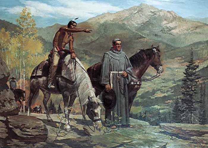
Fathers Francisco Atanasio Dominguez and Silvestre Velez de Escalante were two Spanish priests who, with a group of Spanish soldiers, explored southern Utah and traveled along the North Rim of the Canyon in Glen and Marble Canyons in search of a route from Santa Fe to California in 1776. They eventually found a crossing, formerly known as the "Crossing of the Fathers," that today lies under Lake Powell.
Also in 1776, Fray Francisco Garces, a Franciscan missionary, spent a week near Havasupai, unsuccessfully attempting to convert a band of Native Americans to Christianity. He described the Canyon as "profound".
James Ohio Pattie, along with a group of American trappers and mountain men, may have been the next European to reach the Canyon in 1826.
Jacob Hamblin, a Mormon missionary, was sent by Brigham Young in the 1850s to locate easy river crossing sites in the Canyon. Building good relations with local Native Americans Hualapai Nation and white settlers, he discovered the Crossing of the Fathers, Lee's Ferry in 1858 and Pierce Ferry (later operated by, and named for, Harrison Pierce) - the latter two the only two sites suitable for ferry operation. He also acted as an advisor to John Wesley Powell before his second expedition to the Grand Canyon, serving as a diplomat between Powell and the local native tribes to ensure the safety of his party.
In 1857, Edward Fitzgerald Beale was superintendent of an expedition to survey a wagon road along the 35th parallel from Fort Defiance, Arizona to the Colorado River. He led a small party of men in search of water on the Coconino Plateau near the Canyon's South Rim. On September 19, near present day National Canyon, they came upon what May Humphreys Stacey described in his journal as " ... a wonderful canyon four thousand feet deep. Everyone (in the party) admitted that he never before saw anything to match or equal this astonishing natural curiosity."
Also in 1857, the U.S. War Department asked Lieutenant Joseph Ives to lead an expedition to assess the feasibility of an up-river navigation from the Gulf of California. Also in a stern wheeler steamboat "Explorer", after two months and 350 miles (560 km) of difficult navigation, his party reached Black Canyon some two months after George Johnson. The "Explorer" struck a rock and was abandoned. Ives led his party east into the Canyon - they may have been the first Europeans to travel the Diamond Creek drainage and traveled eastwards along the South Rim. In his "Colorado River of the West" report to the Senate in 1861 he states that "One or two trappers profess to have seen the canon."
According to the San Francisco Herald, in a series of articles run in 1853, they give this honor to Captain Joseph R. Walker, who in January 1851 with his nephew James T. Walker and six men, traveled up the Colorado River to a point where it joined the Virgin River and continued east into Arizona, traveling along the Grand Canyon and making short exploratory side trips along the way. Walker said he wanted to visit the Moqui Indians, as the Hopi were then called by whites. He had met these people briefly in previous years, thought them exceptionally interesting and wanted to become better acquainted. The Herald reporter took it from there, writing: "We believe that Capt. Joe Walker is the only white man in this country that has ever visited this strange people."
In 1858, John Strong Newberry became probably the first geologist to visit the Grand Canyon.
In 1869, Major John Wesley Powell led the first expedition down the Canyon. Powell set out to explore the Colorado River and the Grand Canyon. Gathering nine men, four boats and food for 10 months, he set out from Green River, Wyoming on May 24. Passing through dangerous rapids, the group passed down the Green River to its confluence with the Colorado River, near present-day Moab, Utah and completed the journey with many hardships through the Grand Canyon on August 13, 1869.
In 1871 Powell first used the term "Grand Canyon"; previously it had been called the "Big Canyon".
In 1889, Frank M. Brown wanted to build a railroad along the Colorado River to carry coal. He, his chief engineer Robert Brewster Stanton, and 14 others started to explore the Grand Canyon in poorly-designed cedar wood boats, with no life preservers. Brown drowned in an accident near Marble Canyon: Stanton made new boats and proceeded to explore the Colorado all of the way to the Gulf of California.
In 1908, the Grand Canyon became an official national monument and became a national park in 1919.
U.S. President Theodore Roosevelt visited the Grand Canyon in 1903. An avid outdoorsman and staunch conservationist, he established the Grand Canyon Game Preserve on November 28, 1906. Livestock grazing was reduced, but predators such as mountain lions, eagles, and wolves were eradicated. Roosevelt added adjacent national forest lands and re-designated the preserve a U.S. National Monument on January 11, 1908. Opponents such as land and mining claim holders blocked efforts to reclassify the monument as a U.S. National Park for 11 years. Grand Canyon National Park was finally established as the 17th U.S. National Park by an Act of Congress signed into law by President Woodrow Wilson on February 26, 1919.
The federal government administrators who manage park resources face many challenges. These include issues related to the recent reintroduction into the wild of the highly endangered California condor, air tour overflight noise levels, water rights disputes with various tribal reservations that border the park, and forest fire management.
The Grand Canyon National Park superintendent is Steve Martin. Martin was named superintendent on February 5, 2007, to replace retiring superintendent Joe Alston. Martin was previously the National Park Service Deputy Director and superintendent of several other national parks, including Denali and Grand Teton. Federal officials started a flood in the Grand Canyon in hopes of restoring its ecosystem on March 5, 2008. The canyon's ecosystem was permanently changed after the construction of the Glen Canyon Dam in 1963.
Between 2003 and 2011, 2,215 mining claims have been requested that are adjacent to the Canyon, including claims for uranium mines. Mining has been suspended since 2009, when U.S. Interior Secretary Ken Salazar temporarily withdrew 1 million acres (4,000 km2) from the permitting process, pending assessment of the environmental impact of mining. Critics of the mines are concerned that, once mined, the uranium will leach into the water of the Colorado River and contaminate the water supply for up to 18 million people.
Grand Canyon National Park is one of the world's premier natural attractions, attracting about five million visitors per year. Overall, 83% were from the United States: California (12.2%), Arizona (8.9%), Texas (4.8%), Florida (3.4%) and New York (3.2%) represented the top domestic visitors. Seventeen percent of visitors were from outside the United States; the most prominently represented nations were the United Kingdom (3.8%), Canada (3.5%), Japan (2.1%), Germany (1.9%) and The Netherlands (1.2%). The South Rim is open all year round weather permitting. The North Rim is generally open mid-May to mid-October.
Paved roads did not reach the less popular and more remote North Rim until 1926, and that area, being higher in elevation, is closed due to winter weather from November to April. Construction of a road along part of the South Rim was completed in 1935.
A rail line to the largest city in the area, Flagstaff, was completed in 1882 by the Santa Fe Railroad. Stage coaches started to bring tourists from Flagstaff to the Grand Canyon the next year - an eleven-hour journey. Tourism greatly increased in 1901 when a spur of the Santa Fe Railroad to Grand Canyon Village was completed.
The first scheduled train with paying passengers of the Grand Canyon Railway arrived from Williams, Arizona, on September 17th that year. The 64 mile (103 km) long trip cost $3.95, and naturalist John Muir later commended the railroad for its limited environmental impact.Competition with the automobile (see below) forced the Santa Fe Railroad to cease operation of the Grand Canyon Railway in 1968 (only three passengers were on the last run). The railway was restored and reintroduced in 1990 and has since carried hundreds of passengers a day.
The first automobile was driven to the Grand Canyon in 1902. Oliver Lippincott from Los Angeles, California, drove his Toledo Automobile Company-built car to the South Rim from Flagstaff. Lippincott, a guide and two writers set out on the afternoon of January 4 that year anticipating a seven-hour journey. Two days later, the hungry and dehydrated party arrived at their destination; the countryside was just too rough for the 10 horsepower (7 kW) auto. A three day drive from Utah in 1907 was required to reach the North Rim for the first time.Trains, however, remained the preferred way to travel to the canyon until they were surpassed by the auto in the 1930s.
By the early 1990s more than a million automobiles per year visited the park. Air pollution from those vehicles and wind-blown pollution from Flagstaff and even the Las Vegas area has reduced visibility in the Grand Canyon and vicinity. Read More ...
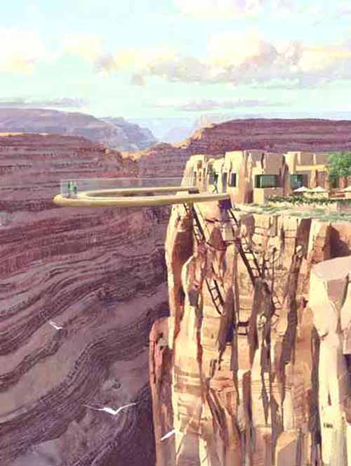
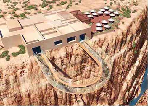
Grand Canyon Skywalk
The Grand Canyon Skywalk is a transparent horseshoe-shaped cantilever bridge and tourist attraction in Arizona near the Colorado River on the edge of a side canyon in the Grand Canyon West area of the main canyon. USGS topographic maps show the elevation at the Skywalk's location as 4,770 ft (1,450 m) and the elevation of the Colorado River in the base of the canyon as 1,160 ft (350 m), and they show that the height of the precisely vertical drop directly under the skywalk is between 500 ft (150 m) and 800 ft (240 m).
Commissioned and owned by the Hualapai Indian tribe, it was unveiled March 20, 2007, and opened to the general public on March 28, 2007. It is accessed via the Grand Canyon West Airport terminal or a 120-mile (190 km) drive from Las Vegas, which includes a 10-mile (16 km) stretch of dirt road which is currently under development. The Skywalk is east of Meadview and north of Peach Springs with Kingman, AZ. being the closest city of some size.
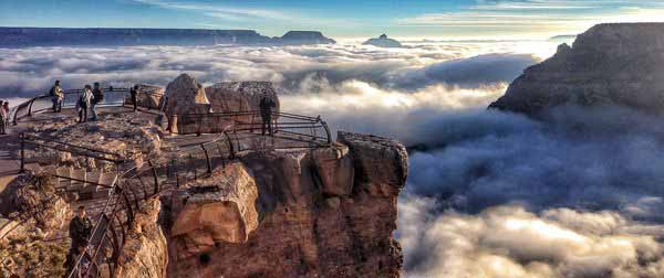
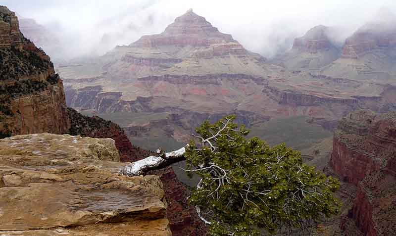
What Created the Rare, Breathtaking Fog Over the Grand Canyon? - National Geographic - December 4, 2013
This past weekend, you could've been above the clouds - but still be earthbound - at Grand Canyon National Park, thanks to a unique weather phenomenon called a temperature inversion.
The weather pattern occurs when cold air is sandwiched between the Earth's surface and the warmer air above. In the Grand Canyon, the inversion created a fleecy blanket of fog over the park following heavy precipitation.