 Strongest 6.1 quake in 25 years strikes California's Bay Area
2014 Napa earthquake Wikipedia
Strongest 6.1 quake in 25 years strikes California's Bay Area
2014 Napa earthquake Wikipedia
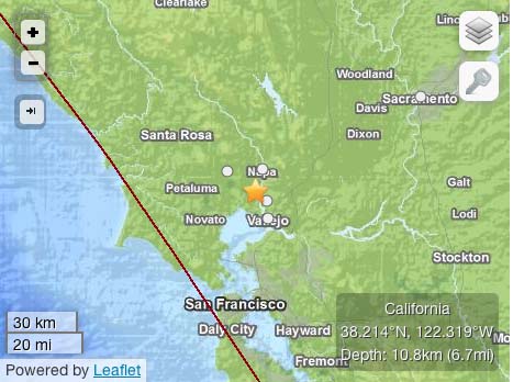
The 2014 Napa earthquake occurred in California, United States, at 10:20:44.00 UTC (3:20am local time) on August 24. The magnitude was measured 6.0 on the moment magnitude scale, and its epicenter was 3.7 miles (6.0 km) northwest of the city of American Canyon, near the West Napa fault. Significant damage was reported in the Napa area, sending at least 87 people to hospitals. More than 42,000 customers lost electric service. It was the largest earthquake to hit the San Francisco Bay Area in since the 1989 Loma Prieta earthquake 25 years earlier.
How the Napa Earthquake Deformed Earth Live Science - September 3, 2014
The 6.0-magnitude earthquake that rocked California's Napa Valley last month not only injured dozens of people and caused millions of dollars in damage, but it also warped the surface of Earth. Satellites with radar vision can see how the Napa earthquake deformed the region from space. Observations from the European Space Agency's (ESA) new Sentinel-1A satellite reveal changes on the surface through a technique known as synthetic aperture radar interferometry.
Odds of major quake in Oklahoma growing, here's why
USGS - August 24, 2014The rate of earthquakes recorded in Oklahoma has increased remarkably in less than a year, the U.S. Geological Survey warned - three months ago - that the chances of a damaging temblor in Central Oklahoma have increased significantly. Further, the federal agency reported that a statistical analysis indicates oilfield wastewater injected into deep geological formations is a likely contributing factor to the increased number of quakes.
Reviewing the New Madrid Seismic Zone
Illinois, Indiana, Missouri, Arkansas, Kentucky, Tennessee and Mississippi
6.9-magnitude quake strikes Peru, USGS says CNN - August 24, 2014
A strong earthquake struck southern Peru on Sunday evening, injuring at least two people and damaging buildings, authorities said. A house was destroyed and 19 other buildings were damaged, including a hospital, Peru's Emergency Operations Center said. The 6.9-magnitude earthquake hit a mountainous area 43 kilometers (27 miles) east-northeast of Tambo at a depth of 101 kilometers (63 miles), according to the U.S. Geological Survey. 5 most powerful recorded earthquakes The USGS revised down the quake's strength from the magnitude of 7.0 that it initially reported, as well as adjusting its data on the location and depth of the epicenter.
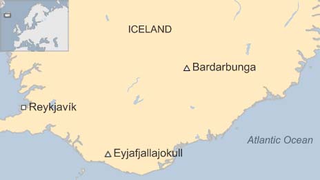
Iceland volcano: Eruption under ice-cap sparks red alert BBC - August 24, 2014
Strong quakes around Bardarbunga Volcano BBC - August 24, 2014
Two new earthquakes have shaken the Bardardunga volcano in Iceland, which is already under a "red alert" aviation warning because of fears an eruption. They are the strongest earthquakes to hit the volcano since seismic activity began on Tuesday. Authorities said there had not been a major eruption but have closed the airspace in the area as a precaution. Iceland's Eyjafjallajokull volcano erupted in 2010, producing ash that disrupted air travel across Europe.
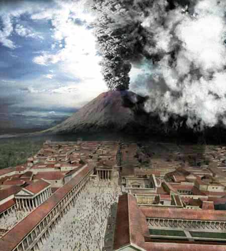
Mount Vesuvius erupts. The cities of Pompeii, Herculaneum, and Stabiae are buried in volcanic ash. Very fine ash particles remain high in the atmosphere for years, spreading around the world by high-altitude winds. This suspended material contributes to often spectacular sunsets, as well as an optical phenomenon known as Bishop's Ring.

Krakatau Erupts, Changes World ... Again Wired
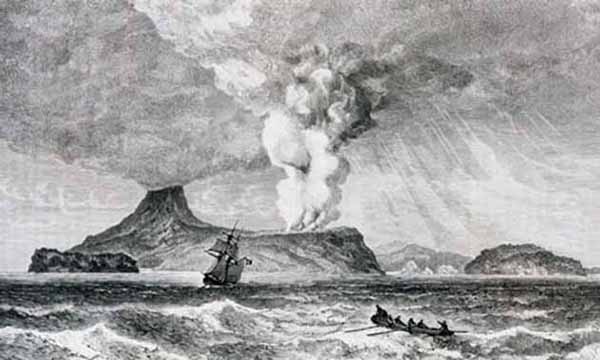
Krakatau Erupts Wikipedia