Aboriginal sacred sites are areas or places in Australia of significant Aboriginal Australian meaning within the animist context of the localised indigenous belief system. Most are somehow related to Aboriginal mythology, known as 'The Dreaming, or The Dreamtime'.
The Dreaming / Dreamtime is a term used to refer collectively to aboriginal religious beliefs. These beliefs endeavor to explain the questions of ultimate human reality, including the origins of humans and animals. The dreaming is a constant phenomenon which includes the past, present and future. They believed that the Spirits who initially inhabited the land were their ancestors and their identity was derived from the spirits from whom they were meant to be descended.
Particular tribes had their own totem which was an animal often native to their tribe's territory. Their way of life was based on their relationship with the land, which they believed to be their origin, sustenance and ultimate destiny. They in turn saw it as their duty to look after the land and take only what they needed. The beliefs of the dreaming are diverse as different tribes have different beliefs which may differ depending on variables such as gender, location and totem. Many sacred traditions and customs took place at these sites. Male sites may be forbidden to women (men's business) and Female sites may be forbidden to men (women's business - for example: birthing sites).
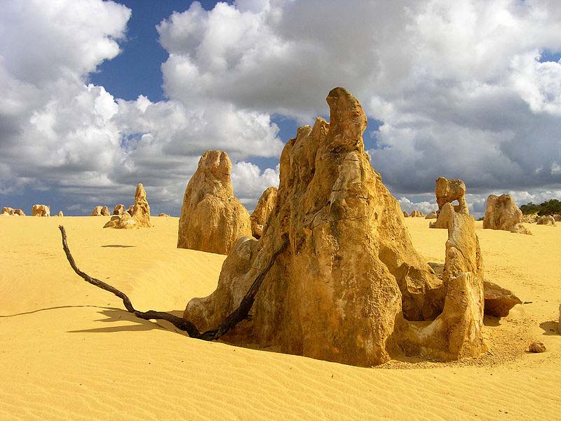
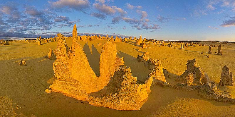
he Pinnacles are limestone formations contained within Nambung National Park, near the town of Cervantes, Western Australia. The raw material for the limestone of the Pinnacles came from seashells in an earlier epoch rich in marine life. These shells were broken down into lime rich sands which were blown inland to form high mobile dunes. The mechanisms through which the Pinnacles were formed from this raw material are the subject of some controversy, with three mechanisms having been proposed:
they were formed through the preservation of casts of trees buried in coastal aeolianites where roots became groundwater conduits, resulting in precipitation of indurated (hard) calcrete. Subsequent wind erosion of the aeolianite would then expose the calcrete pillars.
On the basis of the mechanism of formation of smaller Ňroot castsÓ occurring in other parts of the world, it has been proposed that plants played an active role in the creation of the Pinnacles, rather than the rather passive role detailed above. The proposal is that as transpiration draws water through the soil to the roots, nutrients and other dissolved minerals flow toward the root.
This process is termed "mass-flow" and can result in the accumulation of nutrients at the surface of the root, if the nutrients arrive in quantities greater than needed for plant growth. In coastal aeolian sands which have large amounts of calcium (derived from marine shells) the movement of water to the roots would drive the flow of calcium to the root surface. This calcium accumulates at high concentrations around the roots and over time is converted into a calcrete. When the roots die, the space occupied by the root is subsequently also filled with a carbonate material derived from the calcium in the former tissue of the roots and possibly also from water leaching through the structures. Although evidence has been provided for this mechanism in the formation of root casts in South Africa, evidence is still required for its role in the formation of the Pinnacles.
In Australian Aboriginal mythology Baiame (Baayami or Baayama) was the Creator God and Sky Father in the dreaming of several language groups (e.g. Kamilaroi, Eora, Darkinjung, and Wiradjuri), of Indigenous Australians of South-East Australia.
The Baiame myth tells how Baiame came down from the sky to the land, and created rivers, mountains, and forests. He then gave the people their laws of life, traditions, songs, and culture. He also created the first initiation site. This is known as a bora; a place where boys were initiated into manhood. When he had finished, he returned to the sky, and people called him the Sky Hero or All Father or Sky Father.
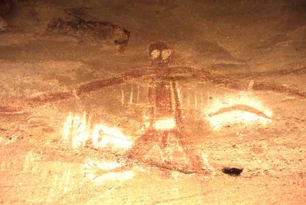
He is said to be married to Birrahgnooloo (Birran-gnulu), who is often identified as an emu, and with whom he has a son Daramulum (Dharramalan). In other stories Daramulum is said to be brother to Baiame. It was forbidden to mention or talk about the name of Baiame publicly. Women were not allowed to see drawings of Baiame nor approach Baiame sites - which are often male initiation sites (boras).
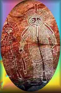
In rock paintings Baiame is often depicted as a human figure with a large head-dress or hairstyle, with lines of footsteps nearby. He is always painted in front view; Daramulum is drawn in profile. Baiame is often shown with internal decorations such as waistbands, vertical lines running down the body, bands and dots. The dots are said to have given him power over smallpox.
The missionary William Ridley adopted the name of Baiame for the Christian God when translating into Gamilaraay (the language of the Kamilaroi). It is sometimes suggested that Baiame was a construct of early Christian missionaries. Doubt is cast on this by a reference to Baiame apparently dating back to 1830-1840 by K Langloh Parker.
In the area surrounding Lake Macquarie in New South Wales, Australia, he was believed to have created all of the mountains, lakes, rivers and caves in the area. After he finished creating, he jumped back up to the spirit world from Mount Yengo, which he flattened. Its flat top can still be seen to this day, near Wollombi Valley. A cave near Milbrodale contains many Wiradjuri Aboriginal paintings, including a large figure of a man who may be Baiame. It is popularly known as the Baiame Cave and is part of a series of rock shelters on an area of 80 hectares. The site is listed on the Register of the National Estate. It depicts him with enormous, long, arms and large staring eyes.
During the Stolen Generation many tribes lost information about their culture, traditional beliefs, stories and ceremonies, and because Aboriginal customs were not written down and recorded, the effect of the Stolen Generation affected all. To the several local tribes, the Wiradjuri, Darkinjung, Wonnarua, Awabakal, Worimi, Biripi and Kamilaroi, it is another piece to the puzzle, helping them uncover lost ceremonies and traditions.
The Flinders Ranges is South Australia's largest mountain range which starts approximately 200 km north of Adelaide. The discontinuous ranges stretch for over 430 km from Port Pirie to Lake Callabonna. Its most characteristic landmark is Wilpena Pound, a large, sickle-shaped, natural amphitheatre covering nearly 80 square kilometres, containing the range's highest peak, St Mary Peak (1170m), and adjoining the Flinders Ranges National Park. The northern ranges host the Arkaroola wilderness sanctuary and the Vulkathunha-Gammon Ranges National Park. The southern part of the ranges are notable for the Pichi Richi scenic railway and Mount Remarkable National Park.
Several small areas in the Flinders Ranges are protected as National Parks. These include the Flinders Ranges National Park near Wilpena Pound and the Mount Remarkable National Park in the southern part of the ranges near Melrose. The Arkaroola Wilderness Sanctuary is a scenic protected area at the northern end of the ranges. In addition, the Dutchman's Stern Conservation Park, west of Quorn, and the Mount Brown Conservation Park, south of Quorn, are protected areas of the ranges. The Heysen Trail and Mawson Trail run for several hundred kilometres along the ranges providing scenic long distance routes for walkers, cyclists and horse-riders.

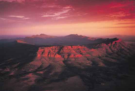
Wilpena Pound is a natural amphitheatre of mountains located 429 kilometres north of Adelaide, South Australia, in the heart of the Flinders Ranges National Park. The Pound is the most northern point with access via a sealed road in this part of the Flinders Ranges. The closest town to the north is Blinman and to the south, Hawker. Attempts at farming the pound failed during the early 20th century. Following this the tourism potential was recognized in 1945. The Flinders Range contains some of the most unusual geological formations in Australia. Indications of gigantic electric arcs are unmistakable.
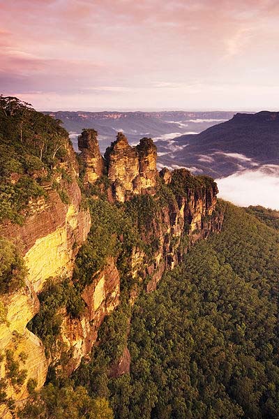
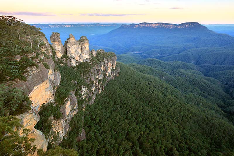
The Blue Mountains is a mountainous region in New South Wales, Australia. It borders on Sydney's metropolitan area, its foothills starting approximately 50 kilometres (31 mi) west of the state capital. The area begins on the west side of the Nepean River and extends westward as far as Coxs River. Geologically, it is situated in the central parts of the Sydney basin.
Consisting mainly of a sandstone plateau, the area is dissected by gorges up to 760 metres (2,490 ft) deep. The highest point of the range is Mount Werong at 1,215 metres (3,986 ft) above sea level. A large part of the Blue Mountains is incorporated into the Greater Blue Mountains Area World Heritage Site, consisting of seven national park areas and a conservation reserve.
The Blue Mountains area includes the local government areas of the City of Blue Mountains, the City of Hawkesbury, the City of Lithgow and Oberon.
When Europeans arrived in Australia, the Blue Mountains had already been inhabited for several millennia by the Gundungurra people, now represented by the Gundungurra Tribal Council Aboriginal Corporation based in Katoomba.
The Gundungurra creation story of the Blue Mountains tells that Dreamtime creatures Mirigan and Garangatch, half fish and half reptile, fought an epic battle which scarred the landscape into the Jamison Valley.
The Gundungurra Tribal Council is a not for profit organisation representing the Gundungurra traditional owners, promoting heritage and culture and providing a support for Gundungurra people connecting back to Country. The Gundungurra web site in the links section below has a virtual video tour of the Upper Blue Mountains.
Gundungurra Tribal Council Aboriginal Corporation has a registered Native Title Claim since 1995 over their traditional lands, which include the Blue Mountains and surrounding areas. Examples of Aboriginal habitation can be found in many places. In the Red Hands Cave, a rock shelter near Glenbrook, the walls contain hand stencils from adults and children. On the southern side of Queen Elizabeth Drive, at Wentworth Falls, a rocky knoll has a large number of grinding grooves created by rubbing stone implements on the rock to shape and sharpen them. There are also carved images of animal tracks and an occupation cave. The site is known as Kings Tableland Aboriginal Site and dates back 22,000 years.
Arthur Phillip, the first governor of New South Wales, first glimpsed the extent of the Blue Mountains from a ridge at the site of today's Oakhill College, Castle Hill. He named them the Carmarthen Hills, 'some forty to sixty miles distan." and he reckoned that the ground was "most suitable for government stock". This is the location where Gidley King in 1799 established a prison town for political prisoners from Ireland and Scotland.
The native Aborigines knew two routes across the mountains: Bilpin Ridge, which is now the location of Bells Line of Road between Richmond and Bell, and the Coxs River, a tributary of the Nepean River. It could be followed upstream to the open plains of the Kanimbla Valley, the type of country that farmers prize.
European settlers initially considered that fertile lands lay beyond the mountains, as was China in the belief of many convicts, but that this didn't matter much, since the mountains were impassable. This idea was, to some extent, convenient for local authorities. An "insurmountable" barrier would deter convicts from trying to escape in that direction.
A former convict, John Wilson, may have been the first European to cross the Blue Mountains. It is also believed that Mathew Everingham, 1795, may have also been partly successful based on letters he wrote at the time which came to light in the late 1980s. Wilson arrived with the First Fleet in 1788 and was freed in 1792. He settled in the bush, living with the Aborigines and even functioning as an intermediary between them and the settlers. In 1797 he returned to Sydney, claiming to have explored up to a hundred miles in all directions around Sydney, including across the mountains. His descriptions and observations were generally accurate, and it is possible that he had crossed the mountains via the southern aspect at the Coxs River corridor, guided by the Aborigines.
Governor Hunter was impressed by Wilson's skills and sent him on an expedition with John Price and others in January 1798. The party crossed the Nepean River and moved southwest towards the present site of Mittagong. There they turned west and found a route along the ridge where today the Wombeyan Caves Road is located. In the process they found a way to go west of the mountains, by going around them instead of across them. In March of the same year, Wilson and Price ventured to the Camden area, and then continued further south until they discovered Thirlmere Lakes, finally almost reaching the present site of Goulburn.
It is possible that the accomplishments of this expedition were suppressed by Hunter, who may not have wanted convicts to know that there was a relatively easy way out of Sydney. Wilson was killed by Aborigines after abducting one of their women for his personal use, but he had accomplished much as an explorer. He was never recognized as the first person to cross the mountains, possibly because his Coxs River journey could not be verified, while his route west of Mittagong may have been the "long way around" for a colony that had its eyes fixed on the sandstone fortress west of the Nepean.
Between 1798 and 1813, many people explored various parts of the mountains, from the Bilpin Ridge to the southern regions, today the site of the Kanangra-Boyd National Park. Still, they did not find a definite route across the mountains.
Official credit for crossing the Blue Mountains was eventually given to Gregory Blaxland, William Lawson and William Charles Wentworth. Following an exploratory trip in 1811, Blaxland, who wanted more grazing land, reasoned that the mountains could be crossed by following the ridges (thus creating the myth that the ridges were the easy way, when the easy way was in fact Coxs River). Accompanied by Lawson and Wentworth, he set out on 11 May 1813, and the party succeeded in crossing the mountains by 31 May. They ventured as far as to what is now Mount Blaxland, just west of Cox's River. On their return to Sydney, Governor Lachlan Macquarie granted them 1,000 acres (4.0 km2) of land each as a reward for their accomplishment.
In November 1813, Macquarie sent the surveyor George Evans on an expedition to confirm the discoveries made by Blaxland and his party. He was also told to see if there existed enough arable land to justify settlement. The issue had become more urgent because the colony was in the grips of a drought.
Evans and his party reached the Fish and Macquarie rivers, and the site of Bathurst.[ On 7 July 1814, construction of a road across the mountains was begun by William Cox. The work was at the behest of Governor Macquarie. 30 convict laborers and 8 guards completed the road on 14 January 1815 after 27 weeks of hard work.
Since the Blue Mountains are rich in coal and shale, mining for these resources began in Hartley Vale in 1865. J.B. North ran a shale mine in the Jamison Valley in the 19th century, and other operations were set up in several places. Locations for mining activities included the Jamison Valley, the upper Grose Valley, Newnes, Glen Davis and the Asgard Swamp area near Mount Victoria. Shale mining failed in the long run because it was not financially viable.
Following European settlement of the Sydney area, the area was named the Carmarthen and Lansdowne Hills by Arthur Phillip in 1788. The Carmarthen Hills were in the north of the region and the Lansdowne Hills were in the south. The name Blue Mountains, however, was preferred and is derived from the blue tinge the range takes on when viewed from a distance. The tinge is believed to be caused by mie scattering which occurs when incoming ultraviolet radiation is scattered by particles within the atmosphere creating a blue-greyish color to any distant objects, including mountains and clouds. Volatile terpenoids emitted in large quantities by the abundant eucalyptus trees in the Blue Mountains may cause mie scattering and thus the blue haze for which the mountains were named.
The Greater Blue Mountains Area was unanimously listed as a World Heritage Area by UNESCO on 29 November 2000, becoming the fourth area in New South Wales to be listed. The area totals roughly 10,000 square kilometres (3,900 sq mi), including the Blue Mountains, Kanangra-Boyd, Wollemi, Gardens of Stone, Yengo, Nattai and Thirlmere Lakes National Parks, plus the Jenolan Caves Karst Conservation Reserve.
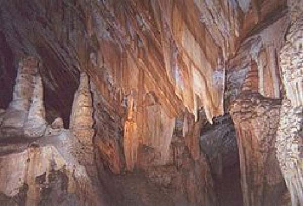
The blue mountains were under the ocean 400 million years ago and coral reefs eventually formed limestone on the ocean floor. Successive layers built up and then about 200 million years ago, the mountains raised up, taking the limestone with them. When underground water ran through the limestone, it dissolved, creating huge caverns beneath the surface of the earth. According to Rex Gilroy, the Dharuk Aborigines knew of a cave so large they called it an underground world. It was entered by a great slit in the side of a cliff and plunged deep into the earth. Today we have no idea of where it is. Other Aborigines were reputed to be able to walk through the mountains underground, but no one knows how or where these caves might be.
In 1931 an explorer named Taylor came from England to explore caves in the Blue Mountains. An Aboriginal guide allegeldy led him to an immense cave called Binoomea in a gully deep in the Jenolan Range. He explored the cave for a week, returning each night. He followed passage after passage until eventually they led to a cavern of such huge proportions that it was hard for him to take it all in. This cavern was covered by a large lake and the walls glowed with phosphorescence. This cave is only one of the hundreds of caves that have been discovered and described by explorers. Most of them have never been found after their initial exploration.
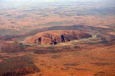
Uluru
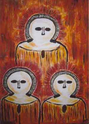
Australian Petroglyphs and Rock Art
Didgeridoo
ANCIENT AND LOST CIVILIZATIONS