Enlarge Map
Enlarge Map
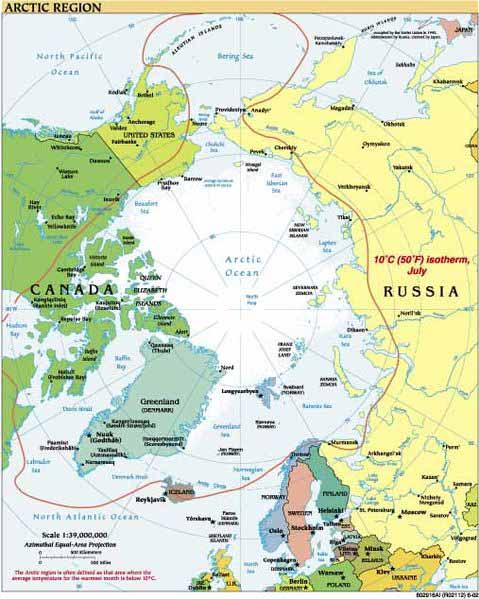
The Arctic is a polar region located at the northernmost part of the Earth. The Arctic consists of the Arctic Ocean and parts of Alaska (United States), Canada, Finland, Greenland (Denmark), Iceland, Norway, Russia, and Sweden. The Arctic region consists of a vast ocean with a seasonally varying ice cover, surrounded by treeless permafrost. The area can be defined as north of the Arctic Circle (66° 33'N), the approximate limit of the midnight sun and the polar night. Alternatively, it can be defined as the region where the average temperature for the warmest month July is below 10° C (50° F); the northernmost tree line roughly follows the isotherm at the boundary of this region.
Socially and politically, the Arctic region includes the northern territories of the eight Arctic states, although by natural science definitions much of this territory is considered subarctic. The Arctic region is a unique area among Earth's ecosystems. The cultures in the region and the Arctic indigenous peoples have adapted to its cold and extreme conditions. In recent years the extent of the sea ice has declined. Life in the Arctic includes organisms living in the ice, zooplankton and phytoplankton, fish and marine mammals, birds, land animals, plants and human societies. Read more ...
Arctic sea ice hits lowest winter level as unprecedented heat smashes records all over Earth NBC - March 27, 2026

Vital Arctic sea ice shrank to tie its lowest measured level for the winter, the season when ice grows, as a warming Earth shattered records across the continents.
The Arctic Has Entered a New Era of 'Extreme Weather', Scientists Warn Science Alert - January 27, 2026
Climate change is shifting the weather patterns of Earth in ways that are far-reaching and long-lasting, and a new study details a noticeable rise in extreme weather events in the Arctic, prompted by rising global temperatures. The study, from an international team of researchers who analyzed decades of data, declares that a "new era" of extreme weather events is now underway in the northernmost region of the planet.
Scientists just found hidden life thriving beneath the Arctic ice Science Daily - October 21, 2025
Melting Arctic ice is revealing a hidden world of nitrogen-fixing bacteria beneath the surface. These microbes, not the usual cyanobacteria, enrich the ocean with nitrogen, fueling algae growth that supports the entire marine food chain. As ice cover declines, both algae production and CO2 absorption may increase, altering the region's ecological balance. The discovery could force scientists to revise predictions about Arctic climate feedbacks.
Arctic: Using ice cores and underwater drones, scientists found something gliding within the frozen water. They say it changes what we know about how life survives in extreme environments. BBC Magazine - September 11, 2025

If you found yourself in the unlikely position of diving beneath the Arctic ice pack, you may notice what looks like a layer of dirt lining the frozen undersurface. Despite appearing lifeless, this green film is in fact very much alive Đ and not only that, but itŐs also moving, a new study has found. The coloration is caused by vast communities of microscopic algae known as diatoms.
Orange rivers signal toxic shift in Arctic wilderness PhysOrg - September 10, 2025
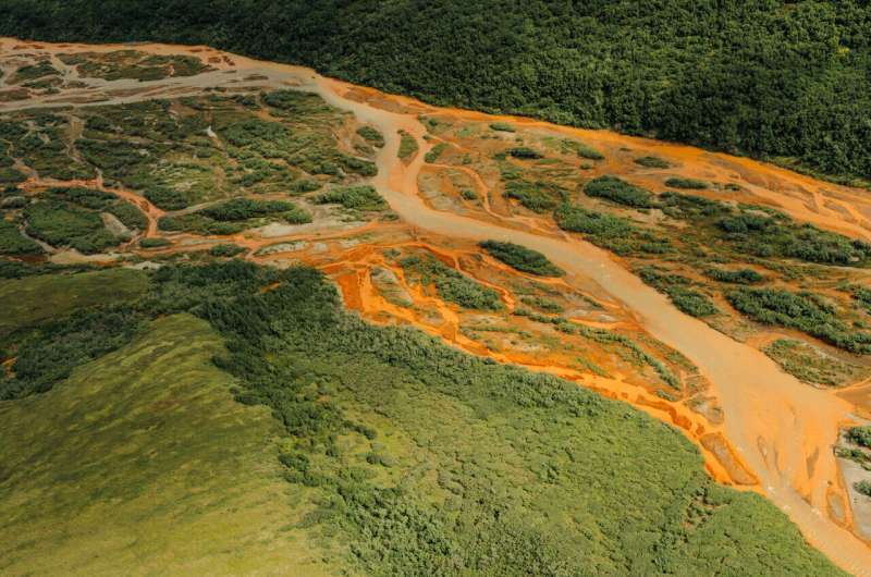
In Alaska's Brooks Range, rivers once clear enough to drink now run orange and hazy with toxic metals. As warming thaws formerly frozen ground, it sets off a chemical chain reaction that is poisoning fish and wreaking havoc on ecosystems. As the planet warms, a layer of permafrost - permanently frozen Arctic soil that locked away minerals for millennia - is beginning to thaw. Water and oxygen creep into the newly exposed soil, triggering the breakdown of sulfide-rich rocks, and creating sulfuric acid that leaches naturally occurring metals like iron, cadmium, and aluminum from rocks into the river. Often times, geochemical reactions like these are triggered by mining operations. But that is not the case this time.
Ominous milestone for the planet - Arctic Ocean's 1st ice-free day could be just 3 years away Live Science - December 5, 2024
The Arctic's ice cover could dip below a crucial threshold as soon as 2027, and will do so inevitably in the next 20 years if greenhouse gas emissions continue, scientists warn.
Meltwater from Greenland and the Arctic is weakening ocean circulation to speed up warming down south, model suggests PhysOrg - November 19, 2024

A vast network of ocean currents nicknamed the "great global ocean conveyor belt" is slowing down. That's a problem because this vital system redistributes heat around the world, influencing both temperatures and rainfall.
Deep below the Arctic Ocean, some plants have adapted to photosynthesize in almost near darkness Live Science - September 25, 2024
Plants can grow with much less light than previously thought, according to a new study on tiny water-based organisms called microalgae. Researchers lowered light sensors into Arctic water to a depth of 164 feet (50 metres) to test how low light levels must become before plant life ceases to exist, with incredible results.
Ice cores show pollution's impact on Arctic atmosphere PhysOrg - September 25, 2024

Ice cores from Alaska and Greenland found that air pollution from the burning of fossil fuels reaches the remote Arctic in amounts large enough to alter its fundamental atmospheric chemistry. The findings illustrate the long reach of fossil fuel emissions and provide support for the importance of clean-air rules, which the team found can reverse the effect.
Mysterious Arctic 'Zombie Fires' Might Not Be Old Flames After All Science Alert - May 29, 2024

So-called "zombie fires" in the peatlands of Alaska, Canada and Siberia disappear from the Earth's surface and smoulder underground during the winter before coming back to life the following spring. These fires puzzle scientists because they appear in early May, way ahead of the usual fire season in the far north, and can reignite for a number of years. Most scientists believe that zombie fires are the remnants of fires on the surface, but we have identified an alternative cause. Our research suggests that rapid atmospheric warming above ground can cause peat soils to suddenly heat up to smouldering temperatures underground, all without any spark or other ignition. These zombie fires may be a case of climate change-driven spontaneous combustion.
Antarctic sea ice near historic lows: Arctic ice continues decline PhysOrg - March 25, 2024
Sea ice at both the top and bottom of the planet continued its decline in 2024. In the waters around Antarctica, ice coverage shrank to near-historic lows for the third year in a row. The recurring loss hints at a long-term shift in conditions in the Southern Ocean, likely resulting from global climate change, according to scientists at NASA and the National Snow and Ice Data Center. Meanwhile, the 46-year trend of shrinking and thinning ice in the Arctic Ocean shows no sign of reversing.
The Arctic could become 'ice-free' within a decade, say scientists PhysOrg - March 5, 2024
The Arctic could see summer days with practically no sea ice as early as the next couple of years
Arctic permafrost could crumble into rivers, unleashing devastating feedback loop Live Science - February 19, 2024
Permafrost isn't just a feature of Arctic landscapes - it actually shapes those landscapes by directing the flow of water. And as global temperatures increase, this permanently frozen ground could give way to create new rivers and expand existing ones, which would release huge quantities of carbon into the atmosphere, potentially resulting in a devastating feedback loop. In a new stud scientists investigated what role permafrost plays in Arctic watersheds - the area of land that channels water, such as rain and snowmelt, into creeks, streams and rivers, and eventually out to reservoirs and oceans.
In and around the Arctic Circle, stunning multicolor clouds have been shining in the sky for days on end Live Science - December 23, 2023
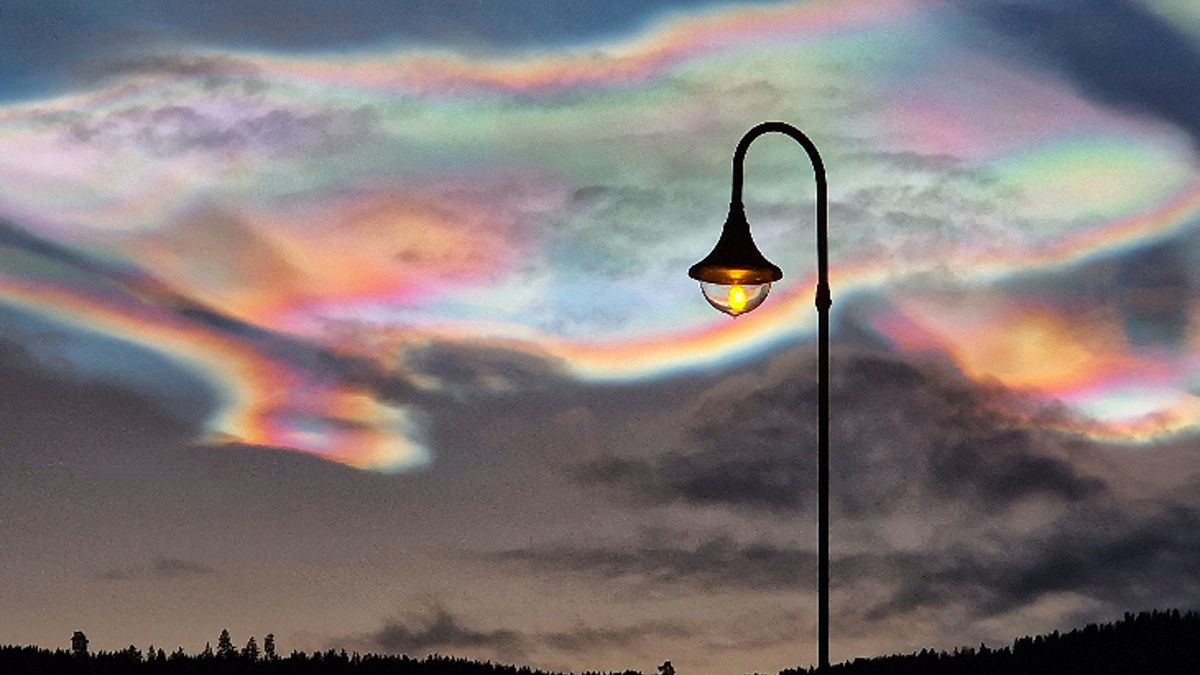
It is very unusual to see so many of these vibrant clouds over such a long period.
Surprising loss of sea ice after record-breaking Arctic storm is a mystery to scientists Live Science - December 7, 2022
Although models accurately predicted the evolution of the Arctic storm, scientists were surprised to see just how much sea ice thickness decreased in the storm's aftermath.
Oldest DNA reveals two-million-year-old lost world BBC - December 7, 2022
The most ancient DNA ever sequenced reveals what the Arctic looked like two million years ago when it was warmer. Today the area in North Greenland is a polar desert, but the genetic material, extracted from soil, has uncovered a rich array of plants and animals. The scientists found genetic traces of elephant-like mastodons, reindeer and geese that roamed among birch and poplar trees, and of marine life including horseshoe crabs and algae.
Logic-defying 'bottom blooms' could sustain hidden ecosystems in Arctic and Antarctica Live Science - November 18, 2022
A pair of new studies has revealed 'highly unlikely' phytoplankton blooms appearing near the seafloor and under sea ice at both Earth's poles. Logic-defying phytoplankton blooms have been discovered lurking beneath the ocean's surface in both of Earth's polar regions, two unrelated new studies have revealed. The highly unlikely "bottom blooms," which grow near the seafloor in the Arctic and below sea ice in Antarctica, could support hidden ecosystems that scientists know nothing about.
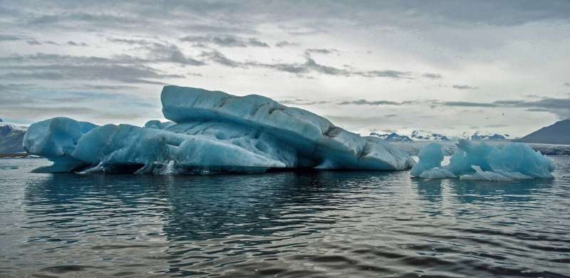
Arctic 'ghost island' that vanished may have actually been a iceberg grounded at the sea bottom Live Science - September 15, 2022
In 2021, an expedition off the icy northern Greenland coast spotted what appeared to be a previously uncharted island. It was small and gravelly, and it was declared a contender for the title of the most northerly known land mass in the world. The discoverers named it Qeqertaq Avannarleq - Greenlandic for the northernmost island. But there was a mystery afoot in the region. Just north of Cape Morris Jesup, several other small islands had been discovered over the decades, and then disappeared. hen a team of Swiss and Danish surveyors traveled north to investigate this "ghost islands" phenomenon, they discovered something else entirely. They announced their findings in September 2022: These elusive islands are actually large icebergs grounded at the sea bottom. They likely came from a nearby glacier, where other newly calved icebergs, covered with gravel from landslides, were ready to float off.
This was not the first such disappearing act in the high Arctic, or the first need to erase land from the map. Nearly a century ago, an innovative airborne expedition redrew the maps of large swaths of the Barents Sea.
Arctic lakes are vanishing in surprise climate finding PhysOrg - August 30, 2022
The Arctic is no stranger to loss. As the region warms nearly four times faster than the rest of the world, glaciers collapse, wildlife suffers and habitats continue to disappear at a record pace. Now, a new threat has become apparent: Arctic lakes are drying up.
Arctic temperatures are increasing four times faster than global warming PhysOrg - July 6, 2022
A new analysis of observed temperatures shows the Arctic is heating up more than four times faster than the rate of global warming. The trend has stepped upward steeply twice in the last 50 years, a finding missed by all but four of 39 climate models.
Alarming heat waves hit Arctic and Antarctica at the same time. Temperatures peaked at least 50 degrees higher than average in both polar regions Live Science - March 23, 2022
Both of Earth's polar regions recently experienced unprecedented simultaneous heat waves that caused temperatures to briefly skyrocket to never-before-seen heights in some areas. While experts say such extreme temperatures cannot be solely attributed to climate change, the unusual phenomenon is nonetheless "dramatic" and "alarming."
Record-breaking heatwaves hit both Antarctica and the Arctic simultaneously this week, with temperatures reaching 47ˇC and 30ˇC higher than normal Science Alert - March 23, 2022
Record-breaking heatwaves hit both Antarctica and the Arctic simultaneously this week, with temperatures reaching 47ˇC and 30ˇC higher than normal. Heatwaves are bizarre at any time in Antarctica, but particularly now at the equinox as Antarctica is about to descend into winter darkness. Likewise, up north, the Arctic is just emerging from winter.
Permafrost thawing faster than expected due to extreme summer rainfall PhysOrg - March 23, 2022
In the past 50 years, the Arctic region has been warming three times faster than the average rate of global warming. This warming thaws the permafrost, the permanently frozen Arctic soil. Permafrost forms the foundation of Arctic ecosystems and the settlements of humans who live on it. When the permafrost thaws, the soil loses its load-bearing capacity. In addition, the organic carbon stored in the frozen soil decomposes more easily into greenhouse gases, such as CO2 and methane, which contribute to global warming. The release of greenhouse gases through permafrost thaw causes what is known as a positive feedback loop, a self-reinforcing process. But in addition to the temperature, the precipitation in the Arctic region is also increasing. In winter, this has a negative impact on the permafrost. A thicker layer of snow in winter has an insulating effect and protects the permafrost from extremely cold air, so it does not cool as much. But little was known about the effect of precipitation in summer.
Arctic winter 2022 sea ice found to be 10th-lowest on record PhysOrg - March 22, 2022
Arctic sea ice extent peaked at 5.75 million square miles (14.88 million square kilometers) and is roughly 297,300 square miles (770,000 square kilometers) below the 1981-2010 average maximum - equivalent to missing an area of ice slightly larger than Texas and Maine combined. This maximum ties with 2015 as the third earliest on record. Sea ice waxes and wanes with the seasons every year. In the Arctic, it reaches its maximum extent around March after growing through the colder months, and shrinks to its minimum extent in September after melting through the warmer months. In the Southern Hemisphere, Antarctic sea ice follows an opposite cycle.
Hot poles: Antarctica, Arctic 40 and 30 degrees Celsius above normal PhysOrg - March 19, 2022
Earth's poles are undergoing simultaneous freakish extreme heat with parts of Antarctica more than 70 degrees (40 degrees Celsius) warmer than average and areas of the Arctic more than 50 degrees (30 degrees Celsius) warmer than average. Weather stations in Antarctica shattered records Friday as the region neared autumn. The two-mile high (3,234 meters) Concordia station was at 10 degrees (-12.2 degrees Celsius),which is about 70 degrees warmer than average, while the even higher Vostok station hit a shade above 0 degrees (-17.7 degrees Celsius), beating its all-time record by about 27 degrees (15 degrees Celsius), according to a tweet from extreme weather record tracker Maximiliano Herrera. The coastal Terra Nova Base was far above freezing at 44.6 degrees (7 degrees Celsius).
Sinkholes as big as a skyscraper and as wide as a city street open up in the Arctic seafloor Live Science - March 17, 2022
Giant "sinkholes" - one of which could devour an entire city block holding six-story buildings - are appearing along the Arctic seafloor, as submerged permafrost thaws and disturbs the area, scientists have discovered. But even though human-caused climate change is increasing the average temperatures in the Arctic, the thawing permafrost that's creating these sinkholes seems to have a different culprit - heated, slowly moving groundwater systems.
The Arctic permafrost at the bottom of the Canadian Beaufort Sea has been submerged for about 12,000 years, since the end of the last ice age, when meltwater from glaciers blanketed the region. Until now, the frozen seafloor had been hidden from scientists' peering eyes. This remote part of the Arctic has only recently become accessible to researchers on ships as climate change causes the sea ice to retreat, the researchers said.
UN confirms hottest temperature ever recorded in the Arctic Live Science - December 16, 2021
The highest temperature ever recorded in the Arctic has been officially confirmed by the United Nations' World Meteorological Organization (WMO), sounding ''alarm bells'' about climate change. The temperature, a ''Mediterranean'' 100 degrees Fahrenheit (38 degrees Celsius) - which was recorded in the Siberian town of Verkhoyansk in June 2020 - was measured at the peak of an extended heat wave. In fact, temperatures across the region that summer averaged as much as 18 F (10 C) above normal, the WMO said in a statement.
Huge hole discovered in Arctic's 'last ice' Live Science - October 18, 2021
Scientists previously thought that this area of ice was the Arctic's most stable, but the giant rift signals that the ancient ice is vulnerable to melt.
Melting permafrost in the Arctic could release radioactive waste and awaken sleeping viruses Live Science - October 6, 2021
As climate change warms the Arctic, melting ice could release hazardous chemicals and radioactive material dating to the Cold War. Vanishing permafrost could also free viruses and bacteria that have slumbered beneath Arctic ice for tens of thousands of years, a new study shows.
By poring over historical records and past studies on contamination, the researchers found that in addition to fallout from nuclear explosions and pollutants such as mercury, arsenic and DDT, so-called Methuselah microorganisms - microbes that have been locked in permafrost for millennia - may awaken if climate change melts Arctic ice and the microbes defrost. That could release bacteria that are resistant to antibiotics, or introduce viruses that humans have never encountered before.
Arctic methane release due to melting ice is likely to happen again PhysOrg - March 22, 2021
Beneath the cold, dark depths of the Arctic ocean sit vast reserves of methane. These stores rest in a delicate balance, stable as a solid called methane hydrates, at very specific pressures and temperatures. If that balance gets tipped, the methane can get released into the water above and eventually make its way to the atmosphere. In its gaseous form, methane is one of the most potent greenhouse gases, warming the Earth about 30 times more efficiently than carbon dioxide. Understanding possible sources of atmospheric methane is critical for accurately predicting future climate change.
The Arctic Ocean was covered by a shelf ice and filled with freshwater PhysOrg - February 3, 2021
About 60,000 to 70,000 years ago, in a particularly cold part of the last glacial period, large parts of Northern Europe and North America were covered by ice sheets. The European ice sheet spanned a distance of more than 5000 kilometers, from Ireland and Scotland via Scandinavia to the Eastern rim of the Kara Sea (Arctic Ocean). In North America, large parts of what is now known as Canada were buried under two large ice sheets. Greenland and parts of the Bering Sea coastline were glaciated too. What was the ice situation like even further North, in the Arctic Ocean? Was it covered by thick sea-ice, or maybe with the tongues of these vast ice sheets were floating on it, far beyond the North Pole?
Towering ice arches in the Arctic are melting, putting 'Last Ice Area' at risk of vanishing Live Science - January 12, 2021
The world's thickest and oldest sea ice is at risk of being lost as the towering ice arches holding it in place experience rapid melting, twice as fast as the rest of the Arctic. The stretch of multiyear sea ice between the Canadian Arctic Archipelago and Greenland - which can stay frozen for more than one melt season - is known as the "Last Ice Area" by scientists. Like all sea ice, it grows and shrinks with the seasons, but has so far lasted through even the warmest summers on record and was expected to endure warming temperatures longer than anywhere else in the Arctic.
The Arctic's 'Last Ice Area' Is Showing Worrying Signs of Fragility Science Alert - January 8, 2021
The stretch of Arctic ice between Greenland and the Canadian Arctic Archipelago is known as 'the Last Ice Area', thought by scientists to have the best chance of surviving the climate crisis Đ but new research suggests it could be more vulnerable to disappearing than previously thought.
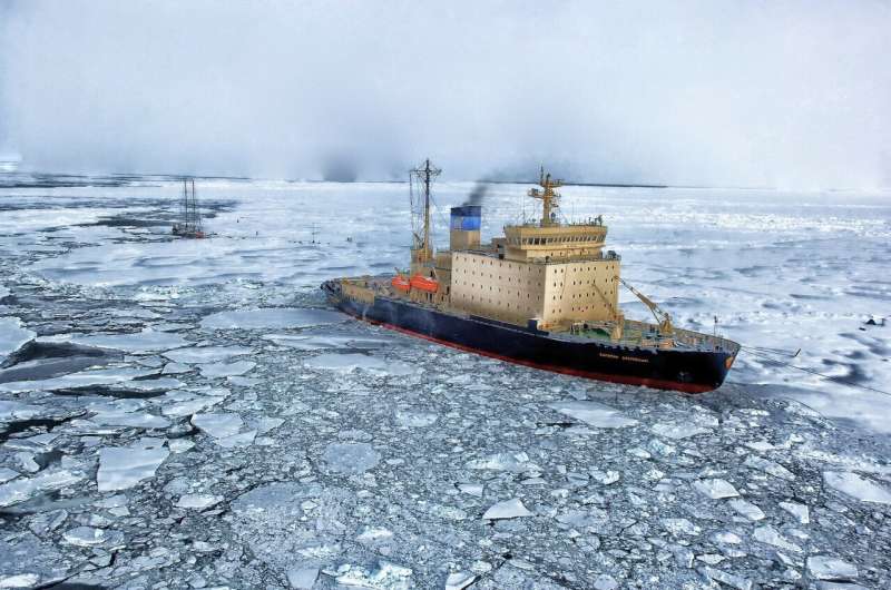
Arctic sea ice goes through 'historic' loss in 2020 Live Science - October 30, 2020
Arctic sea ice has been in decline for a while now, but 2020 is turning out to be by far one of the worst years ever. Every year, like clockwork, the northern ice cap, or sea ice, shrinks in the spring and summer reaching its minimum extent in September and then it grows in the fall and winter to reach its maximum extent in March. But as carbon dioxide and other greenhouse gas emissions have warmed the planet, the area covered by this summer sea ice has gotten smaller and smaller. And the ice has failed to reach its usual maximum extent in the winter. This is a change that's come on fast, with recent years producing much worse sea ice even than the period from 1981 to 2010. But even compared with the worst years of the last decade, this summer has been devastating.
Ice Loss Will Trigger Increased Warming in a Vicious Feedback Loop Science Alert - October 28, 2020
The loss of billions of tonnes of ice from Earth's frozen spaces is likely to increase global temperatures by an additional 0.4 degrees Celsius, according to research Tuesday highlighting the danger of a "vicious circle" of warming.
The Arctic hasn't been this warm for 3 million years - and that foreshadows big changes for the rest of the planet PhysOrg - September 30, 2020
Every year, sea ice cover in the Arctic Ocean shrinks to a low point in mid-September. This year it measures just 1.44 million square miles (3.74 million square kilometers) - the second-lowest value in the 42 years since satellites began taking measurements. The ice today covers only 50% of the area it covered 40 years ago in late summer.
The Arctic is burning in a whole new way - "Zombie fires" and burning of fire-resistant vegetation are new features driving Arctic fires with strong consequences for the global climate PhysOrg - September 28, 2020
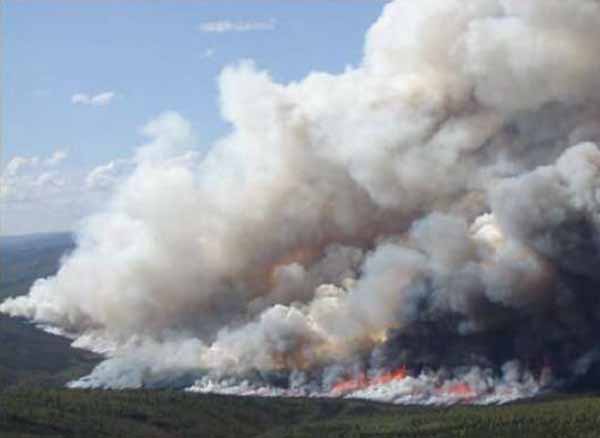
The 2020 Arctic wildfire season began two months early and was unprecedented in scope.
The Arctic is on fire: Siberian heat wave alarms scientists who worry about what it means for the rest of the world PhysOrg - June 24, 2020
The thermometer hit a likely record of 38 degrees Celsius (100.4 degrees Fahrenheit) in the Russian Arctic town of Verkhoyansk on Saturday, a temperature that would be a fever for a person - but this is Siberia, known for being frozen. The catastrophic oil spill from a collapsed storage tank last month near the Arctic city of Norilsk was partly blamed on melting permafrost.
Arctic Permafrost Is Going Through a Rapid Meltdown - 70 Years Early Live Science - June 13, 2019
In the Canadian Arctic, layers of permafrost that scientists expected to remain frozen for at least 70 years have already begun thawing. The once-frozen surface is now sinking and dotted with melt ponds and from above looks a bit like Swiss cheese, satellite images reveal.
The Melting Arctic Is Covering Itself in a Warm Layer of Clouds Live Science - March 7, 2019
The Arctic is melting. The first ice-free summer is coming. The whole melting process is speeding up the warming of the entire Earth. And every autumn, a layer of extra clouds are forming over the ice-thinning Arctic that researchers now believe are speeding that melting up.
There Are 'Superbug' Genes in the Arctic. They Definitely Shouldn't Be There. Live Science - January 28, 2019
A "superbug" gene that was first detected in India - and allows bacteria to evade "last resort" antibiotics - has now been found thousands of miles away, in a remote region of the Arctic,
Models show natural swings in the Earth's climate contribute to Arctic sea ice loss PhysOrg - November 6, 2018
Arctic sea ice loss is enhanced by natural climate fluctuations such as El Ninos and La Ninas. With manmade greenhouse gases on top of the natural climate variability, the decrease in sea ice is even more severe than climate models originally estimated. Using a series of climate models, the team used a "fingerprint" method to estimate the impact of natural climate variability. Natural swings in the Earth's climate contribute to about 40 percent to 50 percent of the observed multi-decadal decline in Arctic sea ice.
Arctic ice sets speed limit for major ocean current PhysOrg - October 17, 2018
The Beaufort Gyre is an enormous, 600-mile-wide pool of swirling cold, fresh water in the Arctic Ocean, just north of Alaska and Canada. In the winter, this current is covered by a thick cap of ice. Each summer, as the ice melts away, the exposed gyre gathers up sea ice and river runoff, and draws it down to create a huge reservoir of frigid fresh water, equal to the volume of all the Great Lakes combined.
Arctic greening thaws permafrost, boosts runoff PhysOrg - October 17, 2018
A new collaborative study has investigated Arctic shrub-snow interactions to obtain a better understanding of the far north's tundra and vast permafrost system. Incorporating extensive in situ observations, Los Alamos National Laboratory scientists tested their theories with a novel 3-D computer model and confirmed that shrubs can lead to significant degradation of the permafrost layer that has remained frozen for tens of thousands of years. These interactions are driving increases in discharges of fresh water into rivers, lakes and oceans.
There's So Much Methane in This Arctic Lake That You Can Light the Air on Fire Live Science - September 27, 2018
All day long, the surface of Esieh Lake in northern Alaska shudders with indigestion. This Arctic lake never fully freezes. Stand next to it, and you'll hear it hiss. Watch it, and you'll see it boil with ancient, bubbling gas. Light a fire over it, and the lake will fart a tower of flame higher than your head. That's exactly what Katey Walter Anthony, an aquatic ecosystem ecologist at the University of Alaska Fairbanks, did in a popular YouTube video from 2010. Walter Anthony has been studying Esieh Lake for the better part of a decade (she also named it). Now, according to a profile written by Chris Mooney for The Washington Post, she knows the cause of the lake's odd behavior. The culprit is a constant seep of the greenhouse gas methane - a lot of methane - spilling out of an ancient reservoir of permafrost (or permanently frozen ground) deep below the tundra.
'Archived' heat has reached deep into the Arctic interior, researchers say Science Daily - August 30, 2018
Arctic sea ice isn't just threatened by the melting of ice around its edges, a new study has found: Warmer water that originated hundreds of miles away has penetrated deep into the interior of the Arctic. That "archived" heat, currently trapped below the surface, has the potential to melt the region's entire sea-ice pack if it reaches the surface, researchers say.
Get Used to Nor'easters - Arctic Warming May Mean More Severe Winters in the Northeast Live Science - March 16, 2018
As average temperatures rise across the planet, the frozen Arctic is heating up faster than anywhere else. With that warmth comes a surprising twist: Unusually warm Arctic winter temperatures are linked to bitter cold and snow in other parts of the Northern Hemisphere, such as the northeastern U.S., parts of northern Europe and northern Asia, according to an analysis of 66 years worth of climate data.
And the relationship between Arctic warmth and severe winter weather was strongest in in the northeastern U.S. - in fact, a temperature spike in the Arctic meant that the U.S. Northeast was two to four times more likely than usual to experience a bout of extreme winter weather, the scientists reported in a new study.
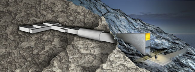
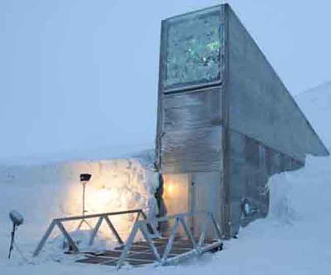
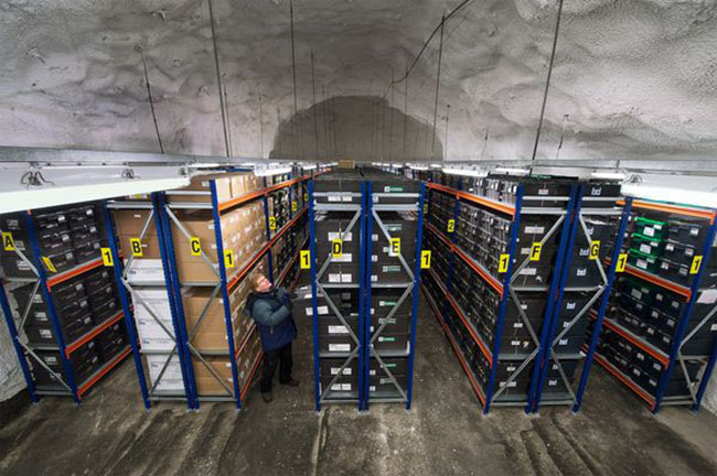
Arctic stronghold of world's seeds reaches one million mark BBC - February 26, 2018
The Svalbard Global Seed Vault is a secure seed bank on the Norwegian island of Spitsbergen near Longyearbyen in the remote Arctic Svalbard archipelago, about 1,300 kilometres (810 mi) from the North Pole. Conservationist Cary Fowler, in association with the Consultative Group on International Agricultural Research (CGIAR), started the vault to preserve a wide variety of plant seeds that are duplicate samples, or "spare" copies, of seeds held in gene banks worldwide. The seed vault is an attempt to insure against the loss of seeds in other genebanks during large-scale regional or global crises. The seed vault is managed under terms spelled out in a tripartite agreement between the Norwegian government, the Global Crop Diversity Trust (GCDT) and the Nordic Genetic Resource Center (NordGen). The Norwegian government entirely funded the vault's approximately NOK 45 million (US$9 million) construction. Storing seeds in the vault is free to end users, with Norway and the Global Crop Diversity Trust paying for operational costs. Primary funding for the Trust comes from such organizations as the Bill & Melinda Gates Foundation and from various governments worldwide. Read more ...
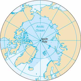
The North Pole, also known as the Geographic North Pole or Terrestrial North Pole, is, subject to the caveats explained below, defined as the point in the Northern Hemisphere where the Earth's axis of rotation meets its surface. It should not be confused with the North Magnetic Pole.
The North Pole is the northernmost point on the Earth, lying diametrically opposite the South Pole. It defines geodetic latitude 90ˇ North, as well as the direction of true north. At the North Pole all directions point south; all lines of longitude converge there, so its longitude can be defined as any degree value. While the South Pole lies on a continental land mass, the North Pole is located in the middle of the Arctic Ocean amid waters that are almost permanently covered with constantly shifting sea ice. This makes it impractical to construct a permanent station at the North Pole (unlike the South Pole). However, the Soviet Union, and later Russia, constructed a number of manned drifting stations on a generally annual basis since 1937, some of which have passed over or very close to the Pole. Since 2002, the Russians have also annually established a base, Barneo, close to the Pole. This operates for a few weeks during early spring. Studies in the 2000s predicted that the North Pole may become seasonally ice-free due to Arctic ice shrinkage, with timescales varying from 2016 to the late 21st century or later.
The sea depth at the North Pole has been measured at 4,261 m (13,980 ft) by the Russian Mir submersible in 2007 and at 4,087 m (13,410 ft) by USS Nautilus in 1958. The nearest land is usually said to be Kaffeklubben Island, off the northern coast of Greenland about 700 km (430 mi) away, though some perhaps non-permanent gravel banks lie slightly closer. The nearest permanently inhabited place is Alert in the Qikiqtaaluk Region, Nunavut, Canada, which is located 817 km (508 mi) from the Pole. Read more ...