The Brandberg Massif
Thunderbolts - June 25, 2007
The Brandberg Massif
Thunderbolts - June 25, 2007The deserts of Namibia hold many unusual geological structures that stretch the imagination and defy conventional explanation. Are electric discharges responsible for their formation?
The continent of Africa reveals a history of violent upheaval and colossal forces. Irrespective of their source, the features that can be found in many places exhibit faults, folds and craters. Conventional theories would place the origin of said features in the distant past and in the lap of continental drift theory and/or plate tectonics. But, do those theories, involving time periods that span billions of years, really tell the tale of what appears to be fresh, relatively unworn geology?
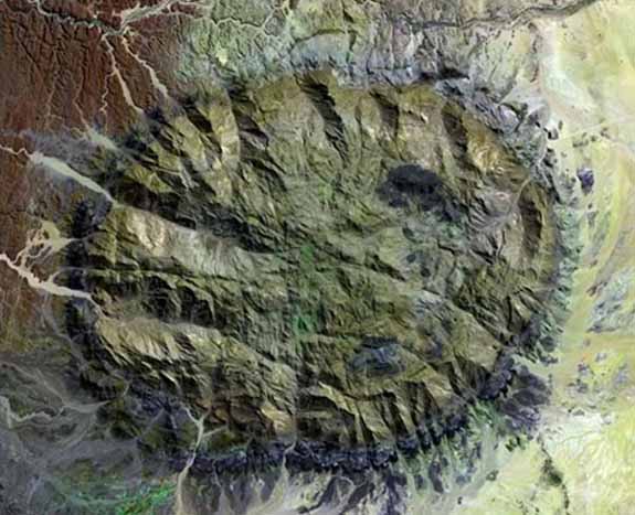
The Brandberg Massif is a circular, dome-shaped structure that rises 2573 meters above the flat plains of Namibia and encompasses an area of 650 square kilometers. Its huge size means that it acts as a Ňrain shadowÓ, wringing moisture from the clouds and preventing precipitation in the desert. The monolith is described as being over 120 million years old and the remains of a granitic intrusion that Ňpunched throughÓ the EarthŐs crust.
The USGS comments: ŇThe mountain's volcanism has long since stilled, but the granite core left behind apparently glows red in the light of the setting sun. The formation is a remnant of a long period of tumultuous volcanic and geologic activity on Earth during which the southern super-continent of Gondwana was splitting apart.Ó
Found in the vicinity of the Brandberg Massif are parallel grooves and ridges that extend for hundreds of miles, Lichtenberg figures covering an enormous area, multiple craters with strange morphology, and dunes that do not move.
Parallel grooves, or striations, abound in the solar system: on Mars, on Venus (the hottest spot), and on Enceladus (a profoundly cold body). If those patterns have been discovered in such various environments, an explanation that includes that variability must be considered.
Lichtenberg figures are named after Georg Christoph Lichtenberg. They form when lightning bolts strike some material on Earth - it can be soil or even human tissue. They have also been generated artificially in blocks of acrylic plastic. Many Lichtenberg figures have been discovered in the south polar region of Mars and have been discussed in previous Thunderbolt Pictures of the Day as Martian Spiders.
Once again, if the topography surrounding the Brandberg Massif - and the Massif, itself - exhibits structural details that have been uncovered on other planets and moons, then the conventional account falls far short of the observations. By describing the birth of the Massif as an event that emerged gradually in the distant past, scientists are neglecting the observational evidence that the formation is, in reality, a fulgamite of titanic proportions that may have formed suddenly.
A fulgamite, or lightning blister, develops when an electric discharge draws material from the surrounding area and compresses it in the center of a spinning electric vortex, leaving a mound-like formation behind. The most notable fulgamite in the solar system, apart from the largest one, Olympus Mons, is probably the face on Mars.
Because the Brandberg Massif rests within an area that reflects the action of gigantic electric arcs, it could very well have formed in a breathtakingly short period of time and not in millions of years.
Brandberg Massif is Namibia's highest mountain, and is located in Damaraland, in the northwestern Namib Desert, near the coast, and covers an area of approximately 650 km.
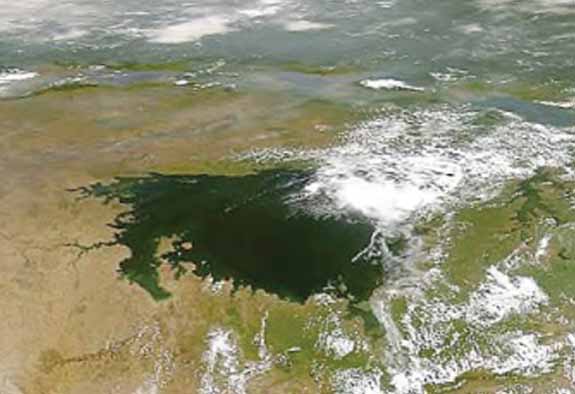
Lake Victoria may be among the largest electrical formations on Earth. Surrounding the lake are several circular structures and other features similar to those found on other planets and moons.
In conventional geological theory of plate tectonics, the continents are floating on a layer of molten rock several miles beneath the Earth's crust. The higher density of the magma and the lower density of the continental rock makes them able to move around on the face of the planet, sometimes colliding and sometimes pulling apart. Huge areas called, "subduction zones" pull vast blocks of sedimentary rock down into the hot interior where they melt into the magma. As the crustal blocks above the melt zones heat up, volcanoes form and erupt the subducted seafloor sediments out onto the land in the form of lava, creating a cycle of destruction and reformation.
The prevailing theory claims that the Great Rift arose because the same force that causes subduction is also causing the ocean bottom and other areas around the planet to crack and spread apart, forming new crust. Because of huge convection currents in the thermal balance of the magma, the continental masses move apart as well as crash together
In and around the Rift Valley vicinity are the largest volcanoes in Africa and the world, including Mt. Kenya and Mt. Kilimanjaro. Some are extinct and the majority have not erupted for hundreds of years. All of them represent what geologists call, "shield volcanoes" that occur over spots that are particularly hot, with magma unusually close to the surface. Mt. Kilimanjaro and the others are really multiple volcanoes that have merged together into larger structures. There are very large fractures beneath the peaks from which the original eruptions took place, similar to the long fracture volcanoes in Hawaii. Those African peaks include Mt. Kilimanjaro, Mt. Elgon, Mt. Meru and many others. They are all located on top of a dual-ridge fault that circles Lake Victoria. One very interesting aspect of the fault is that it begins as a bifurcation in the Afar Depression, loops back on itself as the Western Rift Valley, forms Lake Victoria and then travels to the south, where Lake Malawi fills-in the huge crack.
Near Mt. Meru are sharply cut dendritic ridge or "Lichtenberg" figures that cover hundreds of square miles. Mt. Meru, itself is very unusual in that is a half crater with a sharply pointed central peak. In the Mountains of Patagonia article, such formations were presented as forming from large electric arc discharges, since no volcanic eruption would ever leave a needle-sharp peak in the blasted remains of a half-crater. Certainly Mt. St. Helens did not leave any such basalt monolith behind.
Because Lake Victoria is a circular feature in the midst of a kilometer-deep trench, surrounded by the largest volcanoes in the world, with what appear to be city-wide lightning trackways carved into the rocks in many places. it seems more reasonable to conclude that electrical forces created the Lake and the Rift Valley, just as they produced many other large circular features we have previously described.
Lake Victoria is one of the Great Lakes of Africa.
Shiprock New Mexico
Thunderbolts - August 13, 2007Just as Africa's geography displays evidence for electrical discharge machining, so does the American Southwest.
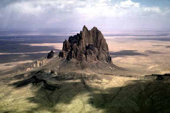
Orthodox theory considers formations like Shiprock to be volcanic intrusions called plutons, though in truth volcanoes and 'volcanic intrusion' are not presently understood. As the theory goes, some sort of geological activity causes magma to move closer to the surface, perhaps to form a volcano or a sub-surface pool of molten rock. After the active phase has passed, the magma within the underground chamber cools and hardens, forming a plug of solidified lava. Due to the slow and steady progress of erosion over millions of years the surrounding landscape wears down and is blown away, uncovering the now solid stone which is more resistant to the erosion that wore away the softer strata. In an electric universe, however, Shiprock and similar forms are suggestive of electric arc impacts.
Fulgurites are created when an electrical discharge strikes the ground and fuses material from the surrounding area, forming an underground impression of the stroke. An accumulation of solidified soil and sand is left behind. After the fulgurite is formed, later more diffuse electrical erosion strips the landscape down to below the level of the fused material, exposing the hardened formation.
A significant aspect of Shiprock's surroundings is the web of "lava dikes" that stretches out from the base of the prominence into the desert. Thought to be part of the eruptive event(s) that formed the structure, the dikes are ridges of metamorphic rock left behind by the erosion of softer overlying sediments. According to standard geology, they are fingers of magma that melted their way along the weak points of the sedimentary layers and then solidified when the volcano became extinct. Examples of such lava dikes are found on Mars, as well. Because Mars does not have the atmospheric density necessary for much erosion and has no running water, it suggests that the dikes formed in some way other than weathering. They have all the earmarks of dual ridge trenches with unusual ripples that flow alongside. In past Picture of the Day articles, trenches of similar morphology have been identified with electric arc discharges.
There is more evidence for our theory of Shiprock's electrical birth. The formation is not alone in the desert, it is surrounded by other similar structures. There are tortuous valleys with scalloped edges cut into the area as well as Lichtenberg figures and fields of stone spheres very much like the "blueberries" on Mars. By ignoring these specific observations, it appears that the conventional explanation will never be complete.
Shiprock, or Shiprock Peak or Ship Rock (winged rock) is a rock formation rising nearly 1,800 feet (550 m) above the high-desert plain on the Navajo reservation, about 12 miles (19 km) southwest of the northern New Mexico town of Shiprock, which is named for the peak.