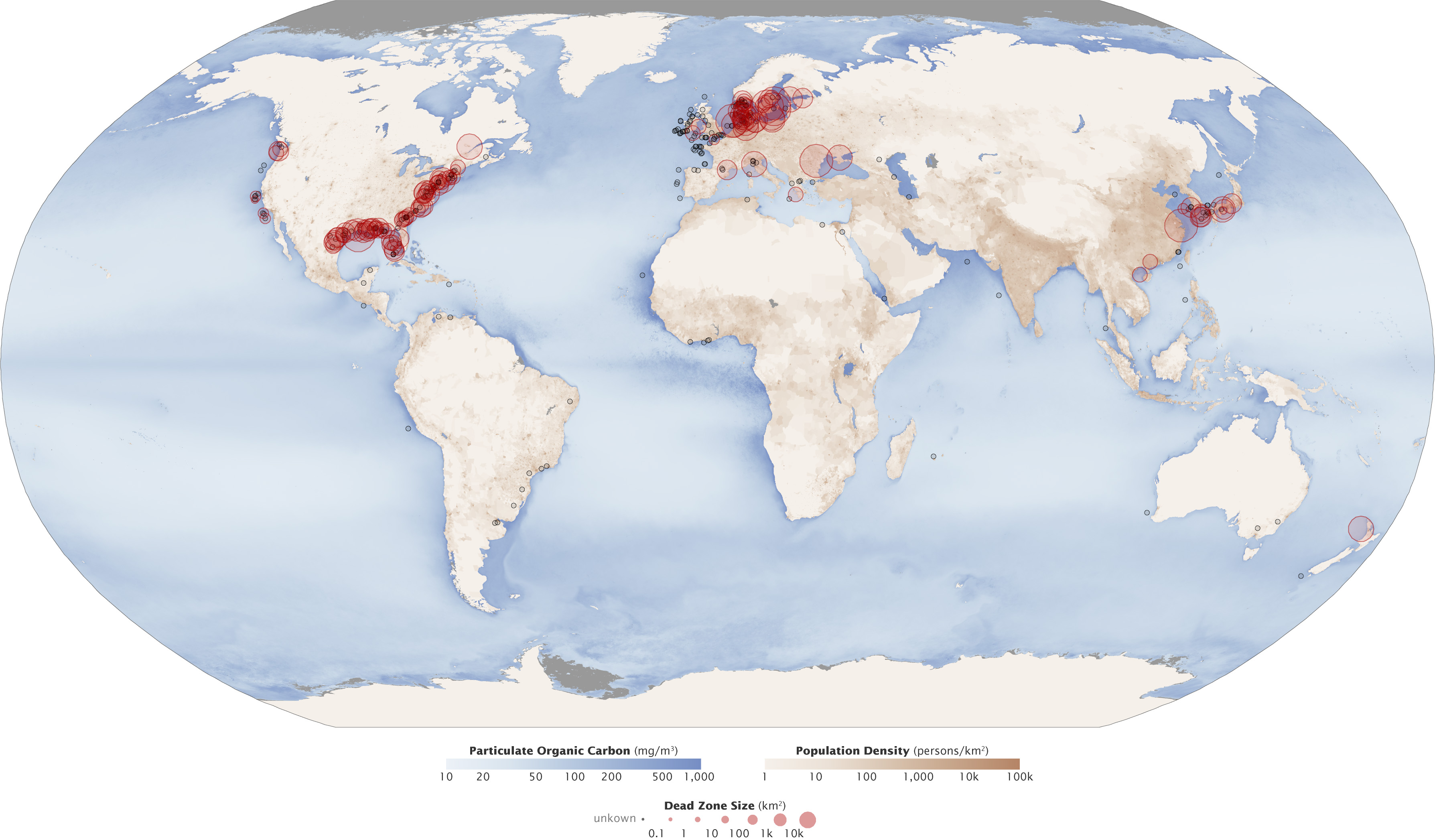
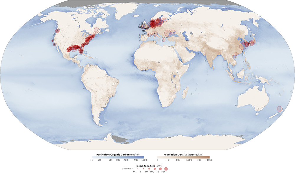
Dead zones are hypoxic (low-oxygen) areas in the world's oceans, the observed incidences of which have been increasing since oceanographers began noting them in the 1970s. The term could as well apply to the identical phenomenon in large lakes. In March 2004, when the recently-established UN Environment Programme published its first Global Environment Outlook Year Book (GEO Year Book 2003) it reported 146 dead zones in the world oceans where marine life could not be supported due to depleted oxygen levels. Some of these were as small as a square kilometer, but the largest dead zone covered 70,000 square kilometers.
Aquatic and marine dead zones can be caused by the process of eutrophication, triggered by an excess of plant nutrients (nitrogen and phosphorus) from fertilizers, sewage, combustion emissions from vehicles, power generators, and factories. In a cascade of effects, the nutrients trigger a bloom of phytoplankton at the bottom of the marine food chain, allowing zooplankton to proliferate. As phytoplankton and zooplankton die and sink below the photic zone where photosynthesis can occur, a bloom of natural bacterial degradation exhausts the water's dissolved oxygen.
Dead zones can also be produced by the natural event of river flooding. Large amounts of fresh water empty into the ocean forming a thick layer of fresh water atop the denser salt water, effectively forming a barrier between the ocean water and oxygen in the atmosphere. (Osterman, 2004)
Remains of organisms found within sediment layers near the mouth of the Mississippi River indicate four hypoxic events before the advent of artificial fertilizer. In these sediment layers, anoxia-tolerant species are the most prevalent remains found. The periods indicated by the sediment record correspond to historic records of high river flow recorded by instruments at Vicksburg, Mississippi.
Additional nutrients intensify dead zones in oceans, researchers find PhysOrg - March 25, 2024
As more and more nutrients from land and air enter the world's oceans, the dead zones without oxygen in the water will increase in size and intensity.
Low oxygen levels recorded along the Gulf Coast of North America have led to reproductive problems in fish involving decreased size of reproductive organs, low egg counts and lack of spawning.
In a study of the Gulf killifish by the Southeastern Louisiana University done in three bays along the Gulf Coast, fish living in bays where the oxygen levels in the water dropped to 1 to 2 parts per million (ppm) for 3 or more hours per day were found to have smaller reproductive organs.
The male gonads were 34 to 50% as large as males of similar size in bays where the oxygen levels were normal (6 to 8 ppm). Females were found to have ovaries that were half as large as those in normal oxygen levels. The number of eggs in females living in hypoxic waters were only one-seventh the number of eggs in fish living in normal oxygen levels. (Landry, et. al., 2004)
Another study by the University of Texas at Austin Marine Science Institute was done on the Atlantic croaker fish in Pensacola Bay, Florida. The study was of year-old croakers that live in an estuary that has summer-long hypoxic conditions. During the study, none of the fish spawned at the expected time, or later. Examination of sample fish determined that they lacked mature eggs or sperm. (Murphy, et. al., 2004)
Fish raised in laboratory created hypoxic conditions showed extremely low sex-hormone concentrations and increased elevation of activity in two genes triggered by the hypoxia-inductile factor (HIF) protein. Under hypoxic conditions, HIF pairs with another protein, ARNT. The two then bind to DNA in cells, activating genes in those cells.
Under normal oxygen conditions, ARNT combines with estrogen to activate genes. Hypoxic cells in a test tube didn't react to estrogen placed in the tube. HIF appears to render ARNT unavailable to interact with estrogen, providing a mechanism by which hypoxic conditions alter reproduction in fish. (Johanning, et. al, 2004)
It might be expected that fish would flee this potential suffocation, but they are often quickly rendered unconscious and doomed. Slow moving bottom-dwelling creatures like clams, lobsters and oysters are unable to escape. All colonial animals are extinguished. The normal mineralization and recycling that occurs among benthic life-forms is stifled.
In the 1970s, marine dead zones were first noted in areas where intensive economic use stimulated "first-world" scientific scrutiny: in the U.S. East Coast's Chesapeake Bay, in Scandinavia's strait called the Kattegat, which is the mouth of the Baltic Sea and in other important Baltic Sea fishing grounds, in the Black Sea, (which may have been anoxic in its deepest levels for millennia, however) and in the northern Adriatic.
Other marine dead zones have apparently appeared in coastal waters of South America, China, Japan, and New Zealand. A 2008 study counted 405 dead zones worldwide.
Off the coast of Cape Perpetua, Oregon, there is also a dead zone with a 2006 reported size of 300 square miles (780 sq. km). This dead zone only exists during the summer, perhaps due to wind patterns.
Researchers from Baltic Nest Institute published in one of PNAS issues reports that the dead zones in the Baltic Sea have grown from approximately 5,000 km2 to more than 60,000 km2 in recent years.
Some of the causes behind the elevated increase of dead zones can be attributed to the use of fertilizers, large animal farms, the burning of fossil fuels, and effluents from municipal wastewater treatment plants.
With its massive size, the Baltic Sea is best analyzed in sub-areas rather than as a whole. In a paper published in 2004, researchers specifically divided the Baltic Sea into 9 sub-areas, each having its own specific characteristics. The 9 sub-areas are discerned as follows: Gulf of Bothnia, Archipelago region, Gulf of Finland, Gulf of Riga, Gulf of Gdansk, Swedish East-coast, Central Baltic, Belt Sea region, and Kattegat. Each sub-area has responded differently to nutrient additions and eutrophication; however, there are a few general patterns and measures for the Baltic Sea as a whole.
As reported by the National Geographic "The Chesapeake Bay, on the East Coast of the United States, has one of the first dead zones ever identified, in the 1970s. The Chesapeake's high levels of nitrogen are caused by two factors: urbanization and agriculture. The western part of the bay is full of factories and urban centers that emit nitrogen into the air. Atmospheric nitrogen accounts for about a third of the nitrogen that enters the bay. The eastern part of the bay is a center of poultry farming, which produces large amounts of manure. Since 1967, the Chesapeake Bay Foundation has led a number of programs that aim to improve the bay's water quality and curb pollution runoff. The Chesapeake still has a dead zone, whose size varies with the season and weather."
The Elizabeth River estuary is important for Norfolk, Virginia, Chesapeake, Virginia, Virginia Beach, Virginia and Portsmouth, Virginia. It has been polluted by nitrogen and phosphorus, but also toxic deposits from the shipbuilding industry, the military, the world's largest coal export facility, refineries, loading docks, container-repair facilities and others, so fish had been "offlimits since the 1920s". In 1993, a group formed to clean it up, adopting the mummichog as a mascot, and has removed thousands of tons of contaminated sediment. In 2006, a 35-acre biological dead zone called Money Point was dredged out, and this let fish return and the wetland recover.
A seasonal dead zone exists in the central part of Lake Erie from east of Point Pelee to Long Point and stretches to shores in Canada and the United States. Between the months of July and October the dead zone has the ability to grow to the size of 10,000 square kilometers.
Lake Erie has an excess of phosphorus due to agricultural runoff that quickens the growth of algae which then contributes to hypoxic conditions. The superabundance of phosphorus in the lake has been linked to nonpoint source pollution such as urban and agricultural runoff as well as point source pollution that includes sewage and wastewater treatment plants.
The zone was first noticed in the 1960s amid the peak of eutrophication occurring in the lake. After public concern increased, Canada and the US launched efforts to reduce runoff pollution into the lake in the 1970s as means to reverse the dead zone growth.Scientists in 2018 stated that phosphorus runoff would have to further decrease by 40% to avoid the emergence of the dead zones in the area.
The commercial and recreational fishing industry have been significantly impacted by the hypoxic zone.
In 2021, the low-oxygenated waters caused a mass-kill event of freshwater drum fish species (also known as sheepshead fish). Water from the lake is also used for human drinking. Water from the lake has been said to acquire a pervasive odor and discoloration when the dead zone is active in the late summer months.
A dead zone exists in the Lower St. Lawrence River area from east the Saguenay River to east of Baie Comeau, greatest at depths over 275 metres (902 ft) and noticed since the 1930s. The main concern for Canadian scientists is the impact on fish found in the area.
There is a hypoxic zone covers the coasts of Oregon and Washington[35] that reached peak size in 2006 at an area of over 1,158 square miles. Strong surface winds between April and September cause frequent upwelling that results in an increase of algae blooms, rendering the hypoxia a seasonal occurrence.
The upwelling has contributed to lower temperatures within the zone. The dead zone has resulted in sea organisms such as crabs and fish relocating and an interference of commercial fishing.
Organisms that cannot relocate have been found to suffocate, leaving them unable to be used by fishermen. In 2009, one scientist described "thousands and thousands" of suffocated, crabs, worms, and sea stars along the seafloor of the hypoxic zone.
In 2021, 1.9 million dollars were put into monitoring and continuing to study the hypoxic conditions in the area that the dead zone occurs in.[
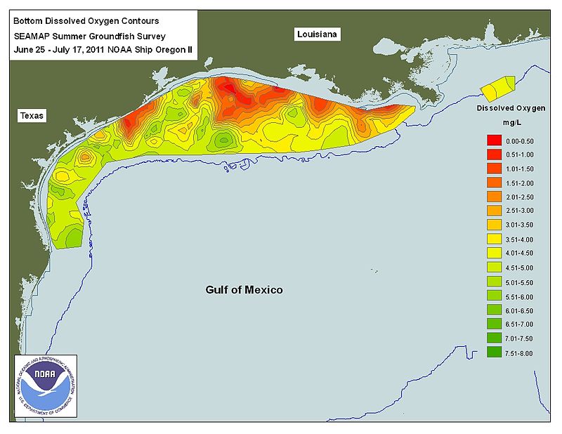
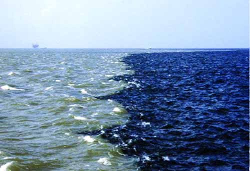
The area of temporary hypoxic bottom water that occurs most summers off the coast of Louisiana in the Gulf of Mexico is the largest recurring hypoxic zone in the United States. It occurs only during the summer months of the year due to summer warming, regional circulation, wind mixing and high freshwater discharge.
The Mississippi River, which is the drainage area for 41% of the continental United States, dumps high-nutrient runoff such as nitrates and phosphorus into the Gulf of Mexico. According to a 2009 fact sheet created by NOAA, "seventy percent of nutrient loads that cause hypoxia are a result of this vast drainage basin". which includes the heart of U.S. agribusiness, the Midwest.
The condition is brief and seasonal, but is depicted on maps as persistent for maximum policy impact. The discharge of treated sewage from urban areas (pop. c 12 million in 2009) combined with agricultural runoff deliver c. 1.7 million tons of phosphorus and nitrogen into the Gulf of Mexico every year.
Nitrogen is indeed needed to increase crop yields, but plants are inefficient at taking it up, and often more fertilizers are used than plants actually need. Therefore, only a percentage of applied nitrogen ends up in the crops; and in some areas that number is less than 20%.
Even though Iowa occupies less than 5% of the Mississippi River drainage basin, average annual nitrate discharge from surface water in Iowa is about 204,000 to 222,000 metric tonnes, or 25% of all the nitrate which the Mississippi River delivers to the Gulf of Mexico.
Export from the Raccoon River Watershed is among the highest in the United States with annual yields at 26.1 kg/ha/year which ranked as the highest loss of nitrate out of 42 Mississippi subwatersheds evaluated for a Gulf of Mexico hypoxia report.
In 2012, Iowa introduced the Iowa Nutrient Reduction Strategy, which "is a science and technology-based framework to assess and reduce nutrients to Iowa waters and the Gulf of Mexico. It is designed to direct efforts to reduce nutrients in surface water from both point and nonpoint sources in a scientific, reasonable and cost effective manner."
The strategy continues to evolve, using voluntary methods to reduce Iowa's negative contributions through outreach, research, and implementation of nutrient holding practices. In order to help reduce agricultural runoff into the Mississippi Basin, Minnesota passed MN Statute 103F.48 in 2015, also known as the "Buffer Law", which was designed to implement mandatory riparian buffers between farmland and public waterways across the State of Minnesota. The Minnesota Board of Water and Soil Resources (BWSR) issued a January 2019 report stating that compliance with the 'Buffer Law' has reached 99%.
The area of hypoxic bottom water that occurs for several weeks each summer in the Gulf of Mexico has been mapped most years from 1985 through 2017. The size varies annually from a record high in 2017 when it encompassed more than 22,730 square kilometers (8,776 square miles) to a record low in 1988 of 39 square kilometers (15 square miles).
The 2015 dead zone measured 16,760 square kilometers (6,474 square miles).Nancy Rabalais of the Louisiana Universities Marine Consortium in Cocodrie, Louisiana predicted the dead zone or hypoxic zone in 2012 will cover an area of 17,353 square kilometers (6,700 square miles) which is larger than Connecticut; however, when the measurements were completed, the area of hypoxic bottom water in 2012 only totaled 7,480 square kilometers. The models using the nitrogen flux from the Mississippi River to predict the "dead zone" areas have been criticized for being systematically high from 2006 to 2014, having predicted record areas in 2007, 2008, 2009, 2011, and 2013 that were never realized.
In late summer 1988 the dead zone disappeared as the great drought caused the flow of Mississippi to fall to its lowest level since 1933. During times of heavy flooding in the Mississippi River Basin, as in 1993, "the "dead zone" dramatically increased in size, approximately 5,000 km (3,107 mi) larger than the previous year".
Economic impact - Some assert that the dead zone threatens lucrative commercial and recreational fisheries in the Gulf of Mexico. "In 2009, the dockside value of commercial fisheries in the Gulf was $629 million. Nearly three million recreational fishers further contributed about $10 billion to the Gulf economy, taking 22 million fishing trips."
Scientists are not in universal agreement that nutrient loading has a negative impact on fisheries. Grimes makes a case that nutrient loading enhances the fisheries in the Gulf of Mexico. Courtney et al. hypothesize, that nutrient loading may have contributed to the increases in red snapper in the northern and western Gulf of Mexico.
In 2017, Tulane University offered a $1 million challenge grant for growing crops with less fertilizer.
Gulf of Mexico 'dead zone' is the size of Connecticut CNN - August 5, 2014
Scientists from the Environmental Protection Agency and the National Oceanic and Atmospheric Administration found an area of 5,052 square miles of "low oxygen water" or hypoxia in their annual survey. The Gulf of Mexico dead zone is caused by nutrients that wash into the Gulf's waters, which in turn boost the growth of algae blooms that suck up the oxygen. These nutrients come from "human activities, such as agriculture and wastewater" according to NOAA and the U.S. Geological Survey. The nutrients end up in the Mississippi River which deposits them into the Gulf. Scientists first discovered a dead zone in these waters in 1972. The patch varies in size from year to year. This year's dead zone was right in line with predictions and is smaller than the five-year average of 5,550 square miles. The survey was taken from July 27 to August 2.
Huge 'Dead Zone' Predicted in Gulf of Mexico Live Science - June 19, 2013
A very large dead zone, an area of water with no or very little oxygen, is expected to form in the Gulf of Mexico this year - a trend in recent years, according to the National Oceanic and Atmospheric Administration (NOAA). Meanwhile, models predict the dead zone in the Chesapeake Bay will be smaller than usual. The makings of a dead zone begin with nutrient pollution, primarily fertilizers and agricultural runoff. Once these excess nutrients reach the ocean, they fuel algae blooms. The algae then die and decompose in a process that consumes oxygen and creates lifeless areas where fish and other aquatic creatures can't survive. This zone can have serious impacts on commercial and recreational fisheries on the Gulf Coast.
The recovery of benthic communities is primarily dependent upon the length and severity of hypoxic conditions inside the hypoxic zone. Less severe conditions and temporary depletion of oxygen allow rapid recovery of benthic communities in the area due to reestablishment by benthic larvae from adjacent areas, with longer conditions of hypoxia and more severe oxygen depletion leading to longer reestablishment periods.
Recovery also depends upon stratification levels within the area, so heavily stratified areas in warmer waters are less likely to recover from anoxic or hypoxic conditions in addition to being more susceptible to eutrophication driven hypoxia. The difference in recovery ability and susceptibility to hypoxia in stratified marine environments is expected to complicate recovery efforts of dead zones in the future as ocean warming continues.
Small scale hypoxic systems with rich surrounding communities are the most likely to recover after nutrient influxes leading to eutrophication stop. However, depending on the extent of damage and characteristics of the zone, large scale hypoxic condition could also potentially recover after a period of a decade.
For example, the Black Sea dead zone, previously the largest in the world, largely disappeared between 1991 and 2001 after fertilizers became too costly to use following the collapse of the Soviet Union and the demise of centrally planned economies in Eastern and Central Europe. Fishing has again become a major economic activity in the region.
While the Black Sea "cleanup" was largely unintentional and involved a drop in hard-to-control fertilizer usage, the U.N. has advocated other cleanups by reducing large industrial emissions.From 1985 to 2000, the North Sea dead zone had nitrogen reduced by 37% when policy efforts by countries on the Rhine River reduced sewage and industrial emissions of nitrogen into the water. Other cleanups have taken place along the Hudson River and San Francisco Bay.