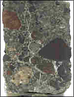
Subterranean Surprises Caves unveil the origins of man - October 2002 - Smithsonian Institute
JULY 1999 - BBC
Scientists have discovered the remains of a "lost continent" beneath the waves of the Indian Ocean.
Drilling by the Joides Resolution research vessel, which traverses the seas extracting samples from beneath the sea floor, suggests that the continent, about a third the size of present day Australia, sank from sight only 20 million years ago.
It lies beneath the southern Indian Ocean. Called the Kerguelen Plateau, it is one of the most remote places on Earth.
The Joides Resolution, the world's largest research vessel, bored a series of holes through the undersea plateau, which is about two kilometres below the ocean surface.
Spores and pollen
It brought to the surface many types of rocks associated with explosive volcanism, as well as sedimentary rocks similar to those found in India and Australia.
"We found abundant evidence that much of the Kerguelen Plateau formed above sea level," said Dr Mike Coffin of the University of Texas.
"Wood fragments, a seed, spores and pollen recovered in 90 million year-old sediment from the central Kerguelen Plateau indicates that it was above sea level."
Scientists believe that it rose out of the ocean about 110 million years ago, following a series of huge volcanic eruptions.
Small dinosaurs
Fifty million years ago, it may have been covered in lush ferns, moist with tropical humidity.
Small dinosaurs would have hidden in the undergrowth stalking their prey.
Twenty million years ago, it started to sink beneath the waves of what is now the Indian Ocean.
Scientists hope that studying the region will help them understand the break-up of Australia, India and Antarctica.
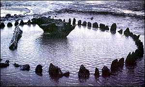
Timber circle was gateway to the after-life
July 1999 - BBC
A circle of waterlogged wooden posts found on a remote beach in Norfolk, England, is transforming our knowledge of Bronze Age culture 4,000 years ago.
The 55 posts, together with the up-turned stump of an oak tree in the middle, were first spotted on the beach at Holme, near Hunstanton, last November. They had become exposed after the peat dune covering them was swept away by winter storms.
Norfolk County Council's Archaeological Unit identified the find as a Bronze Age timber circle dating from around 2000 BC - roughly contemporary with Stonehenge. Inevitably, the circle was dubbed Seahenge.
Left to rot
It is thought timber circles were used by prehistoric cultures to expose their dead to the elements, birds and wild animals - a practice called excarnation. The belief was that allowing the flesh to rot from the bones in the open air would liberate the dead person's spirit.
The archaeologists say the find is unique in Britain, and the best preserved example in Europe.
"This is the first time we've ever found a timber circle intact in Britain," said Mark Brennand of the Norfolk Archaeological Unit. "The sites of timber circles are not uncommon, but up to now all we have seen are the soil markings where the timbers once stood before they crumbled away.
"Here, the circle was built in water-logged ground so it's never dried out and the timbers have been preserved,"
What really excited the archaeologists was the discovery of the large inverted oak stump in the centre of the circle.
It is thought to have formed a sort of altar on which the bodies would have been placed to decay.
"Other circle sites we have looked at had large pits in the centre but we had no idea what caused them because the stump itself had long disappeared," said Mark Brennand. "Now we know what was there, we can go back and re-evaluate the sites."
Dr Francis Pryor, President of the Council for British Archaeology, believes the symbolism of the upside-down oak tree is very important to understanding the Bronze Age mind.
"We often find everyday objects deliberately turned upside down at Bronze Age sites. The inverted oak is a very complex statement. It is the world turned upside down, just as death is an inversion of life.
"From a ritual point of view it symbolises taking objects out of this world and placing them in the next. We're not absolutely sure what these people thought that next world was, but we think they envisaged a parallel world inhabited by their ancestors," Dr Pryor said.
Edge of the unknown
Forty centuries ago Seahenge would have been further inland, rather than on the beach as it is now.
An excavation by the Norfolk Archaeology Unit suggests that the circle was originally constructed on swampy ground up to a kilometre from the sea, which the waves covered at a later date.
Dr Pryor believes the positioning of the timber circle is significant. He suggests that to Bronze Age man the obvious symbolism of the coastline as a divider between two worlds, land and sea, made it an appropriate place to mark the transition between this world and the next.
Other archaeologists disagree. They think the position of Bronze Age funerary sites was chosen simply to mark the borders of land held by the family or community.
Studies of the Seahenge timbers could help answer another historical puzzle. Excavations of Bronze Age burial sites have turned up a disproportionate number of male remains. This might be explained if the bodies of many women and children had been disposed of in timber circles like Seahenge and the body parts scattered.
The archaeologists have to work fast to save Seahenge. The circle is close to the low tide mark on the beach and could be destroyed by wave erosion now it has been exposed.
English Heritage, the UK Government agency responsible for ancient monuments, is also worried about the numbers of sightseers and souvenir hunters visiting the site.
To protect the fragile remains it was decided to remove the timbers and take them away for analysis and conservation. Once lifted, they would be transferred to Flag Fen, near Peterborough, an archaeological centre which specialises in the study of prehistoric timber. But just a few timbers had been excavated when the archaeologists hit a snag.
Not everyone wanted the circle moved. Protestors, including self-styled druids and some local residents, launched a publicity campaign to obstruct the archaeologists' plans, arguing that much of the importance of the circle lay in its location, and that it should not be moved.
The archaeologists have succeeded in getting a High Court injunction preventing some of the protestors approaching the site. The excavation work has been resumed and the transfer of the timbers to Flag Fen is expected to take two weeks.
Techniques similar to those used on Henry VIII's warship the Mary Rose will preserve the finger posts and the central, up-turned tree stump 'altar'.
The posts will be submerged in water tanks to protect them from deterioration. Subsequent forensic work will then include a general examination of the timbers, a study of tool marks, dating of the wood and examination of the activities of prehistoric insects.
Clear tool marks could provide important information on early Bronze Age wood working and construction methods. It is the first time that well preserved tool marks from a complete early Bronze Age site will be studied in Britain. After the timbers have been cleaned, examined and studied, it is hoped that Seahenge will be returned to a spot near its original site and go on public display.
Source: University Of Michigan
Ann Arbor---Scientists from the University of Michigan and Utrecht University have located a piece of Earth's ancient history buried 1,550 miles below its surface. Some 200 million years ago, during the Jurassic period when dinosaurs roamed the world, it was part of a now-extinct ocean bed. Today it rests at the bottom of a churning layer of superheated rock that makes up the Earth's mantle. It is the oldest section of subducted lithosphere ever identified.
"Originally this piece of Earth's crust was located at the bottom of the Mongol-Okhotsk Ocean separating what is now Siberia and Mongolia," said Rob Van der Voo, U-M professor of geological sciences. "As the Siberian and Mongolian continental plates converged between 200 million and 150 million years ago, this material was forced down or subducted deep into the Earth. It has been sinking ever since at an average rate of one centimeter (about one-half inch) per year."
Van der Voo and Utrecht University scientists Wim Spakman and Harmen Bijwaard used seismic tomographic imaging to identify the slab among a "graveyard" of slab remnants in the mantle beneath Siberia's Lake Baikal. Results of their study are published in the Jan. 21 issue of Nature.
The study is significant because it confirms that subducted slabs do eventually reach the bottom of the mantle, according to Van der Voo. The study also illustrates how seismic tomography can provide valuable data to validate theoretical models of what's happening inside our planet. "Greater understanding of deep Earth dynamics will help scientists understand the Earth's internal engine which drives the global convection system and the movement of continental plates," Van der Voo said.
The Earth's crust is broken up into eight major segments or plates and about a dozen minor plates---all moving over the planet's surface at a rate of several inches per year. Continental plates move because they are pushed and pulled by convection currents in the Earth's mantle, which is located just beneath the continental and oceanic plates that make up the Earth's thin crust. When plates collide, one is forced down beneath the other into the mantle creating what geologists call a subduction zone. Because subducting slabs are colder and denser than surrounding mantle material, they tend to sink.
Van der Voo and his colleagues selected the Lake Baikal area for their study because it is the site of an ancient, well-documented subduction zone and is located in a part of the world with many earthquakes and an extensive network of seismic monitoring stations.
Seismologists study the time and trajectory of sound waves traveling through the Earth from earthquake sites to seismic monitoring stations to learn more about the temperature, density and composition of the mantle layer. Acoustic energy travels through different types of mantle material at different speeds. The warmer the material, the longer it takes for sound energy to pass through. Using supercomputers to analyze the travel times and paths of thousands of seismic waves, seismologists can create a three-dimensional image, similar to a CAT scan, of the Earth's interior.
Seismic tomographic images in Van der Voo's study clearly show the slab of subducted material descending to the bottom of the mantle layer. "We didn't expect to see such a strong signal at these depths," Van der Voo added. "Whether its visibility is the result of differences in temperature, composition, pressure or a combination of these remains unclear."
The fact that the slab is located almost directly below the site of its original subduction indicates that the Siberian continental plate has moved very little in the last 150 million years. North America, on the other hand, is steadily moving toward Asia at a rate of about 1.5 inches annually.
"Eurasia will be the next supercontinent," Van der Voo said. "If North America continues drifting west, the Pacific will gradually shrink and eventually the two continents will merge into one."
The research was supported by Utrecht University, the Netherlands Organization for Scientific Research and the U.S. National Science Foundation.
ALPHABETICAL INDEX OF ALL FILES